
Peninsula is a village in northern Summit County, Ohio, United States, along the Cuyahoga River. The population was 536 at the 2020 census. It is part of the Akron metropolitan area. Peninsula is located in the middle of the Cuyahoga Valley National Park. The Boston Mills/Brandywine Ski Resorts are located near Peninsula.

Cuyahoga Valley National Park is a national park of the United States in Ohio that preserves and reclaims the rural landscape along the Cuyahoga River between Akron and Cleveland in Northeast Ohio.
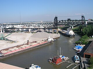
The Flats is a mixed-use industrial, recreational, entertainment, and residential area of the Cuyahoga Valley neighborhood of Cleveland, Ohio, U.S. The name reflects its low-lying topography on the banks of the Cuyahoga River.

The Ohio and Erie Canal was a canal constructed during the 1820s and early 1830s in Ohio. It connected Akron with the Cuyahoga River near its outlet on Lake Erie in Cleveland, and a few years later, with the Ohio River near Portsmouth. It also had connections to other canal systems in Pennsylvania.
Botzum was a hamlet in Northampton Township, Summit County, Ohio around what is now the intersection of Bath and Riverview Roads in Akron and Cuyahoga Falls.
Tinker's Creek, in Cuyahoga, Summit and Portage counties of Ohio, is the largest tributary of the Cuyahoga River, providing about a third of its flow into Lake Erie.
Summit Metro Parks is a Metroparks system serving the citizens of Summit County, Ohio by managing 14,000 acres (5,700 ha) in 16 developed parks, six conservation areas and more than 150 miles (240 km) of trails, with 22.4 miles (36.0 km) of the Ohio & Erie Canal Towpath Trail.

This is a list of properties and districts in Ohio that are listed on the National Register of Historic Places. There are over 4,000 in total. Of these, 73 are National Historic Landmarks. There are listings in each of Ohio's 88 counties.
The Jaite Mill Historic District, also known as Jaite, is a nationally recognized historic district in Cuyahoga and Summit counties in the U.S. state of Ohio. The Cuyahoga County portion of the district is located in the city of Brecksville, while the Summit County portion is located in Sagamore Hills Township. Built in 1903 as the Jaite Company Paper Mill, its center is at the intersection of Vaughn and Riverview roads, north of the crossing of Interstates 80 and 271.

Cuyahoga Valley Scenic Railroad is a Class III railroad operating diesel-electric and steam-powered excursion trains through Peninsula, Ohio, in the Cuyahoga Valley, primarily through the scenic Cuyahoga Valley National Park.

Tinkers Creek Aqueduct is an aqueduct that was constructed to bridge the Ohio and Erie Canal over Tinkers Creek near its confluence with the Cuyahoga River in Valley View, Ohio. It is a relatively rare surviving example of an Ohio and Erie Canal aqueduct. It was originally constructed in 1825-1827 by, and re-built due to flood damage in 1845 and 1905. Tinkers Creek Aqueduct was included in a National Historic Landmark district established in 1966, and it was separately listed on the National Register of Historic Places in 1979. The original Tinkers Creek Aqueduct was a wood plank, steel truss, and Ashlar-sandstone structure constructed in 1827, south of the present aqueduct's location. Cuyahoga River and Tinkers Creek flooding caused continual damage to the original aqueduct, so successive structures were built in 1845 and 1905 in the present location. Today, Tinkers Creek Aqueduct is the only aqueduct which remains of the four original aqueducts in the Cuyahoga Valley. Of Furnace Run Aqueduct, Mill Creek Aqueduct, Peninsula Aqueduct, and Aqueduct; Mill Creek Aqueduct, of newer construction, is the only aqueduct which still carries Ohio and Erie Canal water. After 102 years of flooding, weathering, and deterioration, Tinkers Creek Aqueduct was removed in 2007. The National Park Service is currently working on Phase II of the project to reconstruct it from newer materials.
Whiskey Island is a peninsula at the mouth of the Cuyahoga River at Lake Erie in Cleveland, Ohio. Its current configuration was created in 1827 when the river's mouth was moved to its present location. Part of the city's Cuyahoga Valley neighborhood, the peninsula is 1 mile (1.6 km) long and 0.3 miles (0.48 km) at its widest, bounded by Lake Erie to the north, West 54th Street on the west (roughly), and the Cuyahoga River to the south and east.
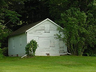
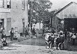
Everett Historic District is a rural village located within Cuyahoga Valley National Park. It is registered on the National Register of Historic Places. Everett is unique for being uncompromised by the pressures of suburban development. It represents a typical unincorporated hamlet of the turn of the 20th century rural America.
The Valley Railway Historic District is a historic district partially located in the Cuyahoga Valley National Park, extending from Independence to Akron, Ohio. It was added to the National Register of Historic Places in 1985.

The Cascade Locks Historic District is a historic district located in Akron, Ohio. It was added to the National Register of Historic Places in 1992.

Cuyahoga Valley is a neighborhood on the Central and South Side of Cleveland, Ohio, located along the Cuyahoga River. Formerly known as Industrial Valley, the neighborhood was originally limited to only one section of the geographic Cuyahoga River Valley, but the city expanded it in 2012 to include the entire valley area. The present neighborhood includes the Flats and extends from the peninsula of Whiskey Island on Lake Erie in the north to the borders of the suburbs of Newburgh Heights and Cuyahoga Heights in the south. To the east, it borders Downtown Cleveland and the neighborhoods of Broadway–Slavic Village and Central. To the west, it borders the neighborhoods of Detroit–Shoreway, Ohio City, Tremont, and Brooklyn Centre.

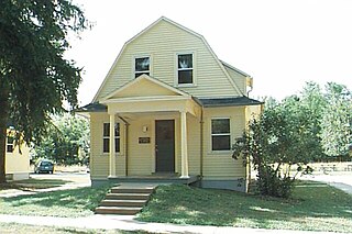
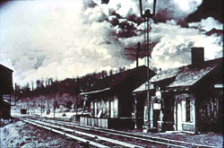
Peninsula Village Historic District is a historic district located on both sides of Ohio State Route 303 in Peninsula, Ohio. The district encompasses the historic core of Peninsula, which is situated inside of Cuyahoga Valley National Park. Peninsula was settled by Hermon Bronson in 1824 and platted in 1837; in its early years, it was a stop along the Ohio and Erie Canal and home to a mill on the Cuyahoga River. Canal traffic and the construction of the Valley Railway in 1875 spurred the village's continued economic growth through the nineteenth century. The district includes examples of Greek Revival, Federal style, and Italianate architecture, all of which were popular nineteenth century styles. Significant buildings in the district include the Town Hall, a railroad depot, Peninsula High School, the G.A.R. Hall, and three churches.
The Ohio and Erie Canalway National Heritage Area is a federally designated National Heritage Area in northeastern Ohio that incorporates the routes of the Ohio and Erie Canal, the Cuyahoga Valley Scenic Railroad, and portions of Cuyahoga Valley National Park.The heritage area follows the path of the canal along the Cuyahoga River for 110 miles (180 km) from Cleveland through Akron and Massillon to New Philadelphia, while the railway runs from Cleveland to Akron to Canton.

The Ohio & Erie Canalway Scenic Byway is a 110-mile (177 km) scenic byway located within the Ohio & Erie Canalway National Heritage Area in Northeast Ohio.
The Valley Railway was a shortline railroad which operated between the city of Cleveland and small town of Zoarville in the state of Ohio in the United States. The railroad was founded in 1871, but the first segment of track did not open until 1880 and the line was not completed until 1884. The Baltimore and Ohio Railroad (B&O) obtained a controlling interest in the Valley Railway in 1890. The railroad went bankrupt in 1895, at which time it was reorganized as The Cleveland Terminal and Valley Railroad Company (CT&V). The B&O took over operation of the CT&V in 1909, and the company was merged with the B&O in 1915.


