Boswell, British Columbia

Last updated
Boswell
settlement
Canada British Columbia location map 2.svg
Red pog.svg
Boswell
Location of Boswell in British Columbia
Coordinates: 49°27′15″N116°45′45″W / 49.45417°N 116.76250°W / 49.45417; -116.76250
CountryFlag of Canada (Pantone).svg  Canada
Province Flag of British Columbia.svg  British Columbia
Region Kootenays
Regional district Central Kootenay
Time zone UTC-7 (MST, PST)
Area codes 250, 778, 236, & 672
Highways BC-3A.svg Hwy 3A

Boswell is an unincorporated community in the West Kootenay region of southeastern British Columbia. The former steamboat landing and temporary ferry terminal is adjacent to McGregor Creek on the east shore of the south arm of Kootenay Lake. [1] [2] Comprising a few kilometres stretched along BC Highway 3A, the location is by road about 48 kilometres (30 mi) north of Creston and by road and ferry about 76 kilometres (47 mi) southeast of Nelson.

Contents

Name origin

McGregor, the former name dating from around 1900, referred to D.C. McGregor of Trail, who preempted the landing site. During a 1906 visit, Governor-General Earl Grey bought orchard land for his son Viscount Howick. Howick was so impressed with Elias John Boswell, who surveyed this property, that he named the enterprise Boswell Ranch. Boswell became the post office name on opening. [3]

Steamboats

Lake steamers Kokanee (left) and Nasookin (right) at Boswell, BC, c.1918. Kokanee and Nasookin at Boswell.jpg
Lake steamers Kokanee (left) and Nasookin (right) at Boswell, BC, c.1918.

Initially, steamboats stopped on request. Later, the scheduled stop of twice a week grew to three times weekly before becoming daily in mid-1914. [4] Completed in 1913, the first government wharf was destroyed by a storm on the official opening day. The subsequent floating wharf was replaced in 1921. [5] Prior to 1931, the settlement depended upon the lake boats for transportation. [6]

In April 1931, the government east–west Kootenay Lake Ferry service began. After two days, the poor road conditions prompted a temporary change to two daily trips to Boswell instead of three to Gray Creek. [7] That September, the three daily trips to Gray Creek were restored. [8] The same substitution occurred the next year for a couple of months. [9] [10]

Roads

The first road was from the Boswell Ranch to the landing. The road was extended to the post office at the Kennedy Ranch in 1912, and soon after, north to Lewis Bay. By 1919, the road stretched about 3 kilometres (2 mi) north and south. [11] By 1931, a dirt road connected Kuskonook and Gray Creek. [12] That year, Greyhound Canada began serving communities along the eastern lakeshore. [13] By 1945, three buses travelled daily in each direction. [14] This highway was paved in 1949. [12]

Mining

During the 1890s, mining activity peaked in the area. D. McGregor prospected on McGregor Creek. In the early 1900s, about 3 kilometres (2 mi) south at Akokli (Goat) Creek, miners worked the stream. Their rock pier for loading ore was one of the first on the east side of the lake. Mining claims were also staked at Lockhart and La France creek, respectively about 6 kilometres (4 mi) and 8 kilometres (5 mi) north of Boswell. [15] The La France Mining Co, formed in 1906, completed extensive underground tunnelling but shipped no ore before the venture collapsed during World War I. [15] Akokli Creek was the industrial heart. The Valparaiso, staked in the mid-1890s, was the most famous property. Mining continued sporadically. However, gold and silver recoveries proved uneconomic. A small aerial tramway to the lakeside was installed in the 1930s, but the mine closed in 1941. [16]

Agriculture

In the early 1900s, about 5 kilometres (3 mi) south, the Ginol family planted strawberries, grapes and fruit trees. [17] By 1912, the Boswell Ranch contained 2,000 fruit trees. [18] The popular fall fairs, which began in 1914, exhibited local fruit and vegetables. [19]

The temperate climate favoured apple orchards and soft fruit, especially cherries, gooseberries, raspberries and strawberries. Boswell established a fruit growers association in 1916 and farmers institute in 1921. The lake boat service, which shipped out produce, largely ceased when the Canadian Pacific Railway opened the Kootenay Landing to Procter link at the beginning of 1931. Rather than allow the soft fruit to over ripen while waiting at the landing, a jam factory was built to process perishable produce. The factory eventually closed and the market for apples diminished by the mid-1950s. [20]

Early community

Early preemptions in the area were for Ken Wattie around 1894, John "Scotty" Gordon in 1898, Duncan McGregor in 1901, and Isaac Lewis in 1904. James Johnstone, a non-resident, was a land promoter who sold properties to many of the early settlers. [21] Mrs Emma Ginol was the inaugural postmaster 1907–1910 and the post office was at the Boswell Ranch. Mrs Mary Kennedy served 1910–1945, using her home. [22] [23]

In 1911, the first Anglican service was held in the A.R. Wilson residence. [24] In 1912, J. Coupland established a small general store. [25] The schoolhouse opened early that year. Miss Laura E. Symonds was the inaugural schoolteacher 1912–1919. A teacherage was built in the 1920s. [26] The school closed in 1947, students being bussed to Crawford Bay. [27] Opened in 1921, the Boswell Memorial Hall was used for church services and various community activities. [28]

The population of Boswell was 75 by 1918, increasing to 97 by 1925. Relief camps providing labour for road construction during the Great Depression swelled the number to 150 by 1932. [29] During the 1940s and 1950s, an orchestra existed. [30] In the 1960s, a small church building was erected. [31]

Later community

The cemetery, still in use, dates from the mid 1920s. [32] Boswell is largely a retirement community. Popular tourist attractions in the area include the nearby Lockhart Beach Provincial Park, Mackie Beach Park, and the Glass House. [6] The annual Lady Grey Flower Show is held in the community hall, a venue which also hosts various social functions. [20] In 2021, the Boswell Historical Society published a new edition of the history titled "Boswell Beginnings and Beyond", comprising about 100 pages of new material. [33]

Destiny Bay

About 3 kilometres (2 mi) south, Donald and Lil West settled in 1928 and developed their property into the Destiny Bay Tourist Camp with cabins and a store. The name came either from a Donn Byrne novel or a belief that the project was the couple's destiny. Prior to the east shore highway construction, guests arrived by sternwheeler. The location became a meal stop for cars and the Greyhound bus. The present lodge was later built. [34] [35] A sawmill was established in 1930 and logging continued into the 1940s. [16]

The October 1963 opening of the Salmo–Creston highway over the Kootenay Pass [36] eliminated most through traffic reducing business viability. By the early 1980s, the main building was unused apart from a section operating as a diner. The three-storey lodge was refurbished and opened as the Destiny Bay Resort in 1982. Tourist accommodation comprises five cottages and three suites in the main lodge. A general store/post office exists across the highway. However, passing traffic remains insufficient to make the store a successful year-round operation. [35]

Footnotes

  1. "Boswell (community)". BC Geographical Names .
  2. "McGregor Creek (creek)". BC Geographical Names .
  3. "Nelson Star". www.nelsonstar.com. 29 Jul 2013.
  4. BLC 1986, p. 31.
  5. BLC 1986, p. 30.
  6. 1 2 "Boswell". kootenaylake.bc.ca.
  7. "Daily News". www.library.ubc.ca. 17 Apr 1931. p. 2.
  8. "Daily News". www.library.ubc.ca. 1 Sep 1931. p. 3.
  9. "Daily News". www.library.ubc.ca. 29 Feb 1932. p. 2.
  10. "Daily News". www.library.ubc.ca. 14 Apr 1932. p. 10.
  11. BLC 1986, p. 33.
  12. 1 2 BLC 1986, p. 34.
  13. Lymbery, Tom (2010). "British Columbia Historical News: Greyhound and Gray Creek". www.library.ubc.ca. 43 (1): 23 (21).
  14. BLC 1986, p. 36.
  15. 1 2 BLC 1986, p. 14.
  16. 1 2 "Boswell and Sanca". www.crowsnest-highway.ca.
  17. BLC 1986, p. 7.
  18. BLC 1986, p. 8.
  19. BLC 1986, p. 49.
  20. 1 2 "Boswell". www.ourbc.com.
  21. BLC 1986, p. 5.
  22. BLC 1986, p. 58.
  23. "Postmasters". www.bac-lac.gc.ca.
  24. BLC 1986, p. 53.
  25. BLC 1986, pp. 40, 73.
  26. BLC 1986, pp. 59–60.
  27. BLC 1986, p. 65.
  28. BLC 1986, p. 46.
  29. BLC 1986, p. 6.
  30. BLC 1986, p. 77.
  31. BLC 1986, p. 54.
  32. "Boswell Cemetery". www.interment.net.
  33. "My Creston Now". www.mycrestonnow.com. 18 Nov 2021.
  34. BLC 1986, p. 116.
  35. 1 2 "Today in BC". www.todayinbc.com. 24 Jun 2019.
  36. "Rossland News". www.rosslandnews.com. 6 Oct 2013.

Related Research Articles

Creston, British Columbia Town in British Columbia, Canada

Creston is a town in the Kootenay region of southeastern British Columbia. By road, Creston is roughly equidistant between Cranbrook and Castlegar along the Crowsnest Highway. The town is approximately 12 km (7.5 mi) north of the Porthill-Rykerts Border Crossing on the Canada–US border.

Trout Lake (British Columbia)

Trout Lake is a ribbon lake in the West Kootenay region of southeastern British Columbia. Between the Selkirk Mountains to the west and the Purcell Mountains to the east, the lake is about 23 kilometres (14 mi) long and 1.6 kilometres (1 mi) wide. Lardeau Creek flows into the northern end and Lardeau River flows from the southern end. BC Highway 31 skirts the northeast shore. The northern end is about 90 kilometres (56 mi) by road and ferry southeast of Revelstoke.

Ymir, British Columbia Unincorporated Community in British Columbia, Canada

Ymir is an unincorporated community in the Selkirk Mountains in the West Kootenay region of southeastern British Columbia. The hamlet is on the west shore of the Salmo River and north shore of Quartz Creek, across the river from the mouth of Ymir Creek. The locality, on BC Highway 6, is by road about 13 kilometres (8 mi) northeast of Salmo and 29 kilometres (18 mi) south of Nelson.

Silverton is a village about 5 kilometres (3 mi) south of New Denver in the West Kootenay region of southeastern British Columbia. The former steamboat landing is at the mouth of Silverton Creek on the eastern shore of Slocan Lake. The locality, on BC Highway 6 at the junction of BC Highway 31A, is about 95 kilometres (59 mi) by road north of Castlegar and 155 kilometres (96 mi) by road and ferry south of Revelstoke.

Balfour is an unincorporated community in the West Kootenay region of southeastern British Columbia. The ferry terminal and former steamboat landing is on the north shore at the entrance to the West Arm of Kootenay Lake. The locality, on BC Highway 3A, is about 33 kilometres (21 mi) northeast of Nelson.

Winlaw is an unincorporated community adjacent to Winlaw Creek on the east side of the Slocan River in the West Kootenay region of southeastern British Columbia. The locality is on BC Highway 6 about 20 kilometres (12 mi) south of Slocan, and 49 kilometres (30 mi) north of Castlegar.

Needles is an unincorporated locality on the west shore of Lower Arrow Lake in the West Kootenay region of southeastern British Columbia. The western terminal for the Needles Ferry to Fauquier, the landing on Highway 6 is 108 kilometres (67 mi) east of Lumby, and 60 kilometres (37 mi) southwest of Nakusp.

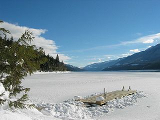
Trout Lake is an unincorporated community in the West Kootenay region of southeastern British Columbia. The former steamboat landing is at the north end of Trout Lake. The locality, on BC Highway 31, is by road about 177 kilometres (110 mi) north of Nelson and 90 kilometres (56 mi) by road and ferry southeast of Revelstoke.

Kootenay Lake ferry

The Kootenay Lake ferry is a ferry across Kootenay Lake in southeastern British Columbia, which operates between Balfour, on the west side of the lake, and Kootenay Bay, on the east side. The MV Osprey 2000 and the MV Balfour are the two vessels used.

Rosebery is an unincorporated community about 6 kilometres (4 mi) north of New Denver in the West Kootenay region of southeastern British Columbia. The former steamboat landing and ferry terminal is at the mouth of Wilson Creek on the eastern shore of Slocan Lake. The locality, on BC Highway 6, is about 106 kilometres (66 mi) by road north of Castlegar and 144 kilometres (89 mi) by road and ferry south of Revelstoke.

Wynndel is an unincorporated community adjacent to Duck Creek, east of the Kootenay River, in the West Kootenay region of southeastern British Columbia. The locality, on BC Highway 3A, is by road about 11 kilometres (7 mi) north of Creston and 128 kilometres (80 mi) southeast of Nelson.

Tarrys is an unincorporated community spanning both shores of the Kootenay River in the West Kootenay region of southeastern British Columbia. The location, on BC Highway 3A, is by road about 14 kilometres (9 mi) northeast of Castlegar, and 30 kilometres (19 mi) southwest of Nelson.

Kootenay Bay is an unincorporated community on the east shore of Kootenay Lake in the West Kootenay region of southeastern British Columbia. The ferry terminal and former steamboat landing, on BC Highway 3A, is by road about 81 kilometres (50 mi) north of Creston and 4.5 kilometres (2.8 mi) west of Crawford Bay.

Queens Bay is an unincorporated community in the West Kootenay region of southeastern British Columbia. The former steamboat landing is on the west shore of Kootenay Lake. The locality, off Highway 31, is about 38 kilometres (24 mi) northeast of Nelson.

Procter is an unincorporated community in the West Kootenay region of southeastern British Columbia. The former steamboat landing is on the south shore at the entrance to the West Arm of Kootenay Lake. By road and ferry, the locality is about 35 kilometres (22 mi) northeast of Nelson.

Ferguson is an unincorporated community in the West Kootenay region of southeastern British Columbia. The near ghost town is immediately northwest of the confluence of Ferguson Creek into Lardeau Creek. The locality, on Ferguson Rd and off BC Highway 31, is by road about 183 kilometres (114 mi) north of Nelson and 96 kilometres (60 mi) by road and ferry southeast of Revelstoke.

Waldo is a ghost town in the East Kootenay region of southeastern British Columbia. About 2 kilometres (1.2 mi) north of Krag, the remnants are submerged beside the east shore of Lake Koocanusa, just north of the mouth of the Elk River. Off BC Highway 93, the site is by road about 69 kilometres (43 mi) southwest of Cranbrook and 48 kilometres (30 mi) southeast of Fernie.

Lemon Creek is an unincorporated community on the east side of the Slocan River in the West Kootenay region of southeastern British Columbia. The locality is on BC Highway 6 about 8 kilometres (5 mi) south of Slocan, and 62 kilometres (39 mi) north of Castlegar.

Porthill-Rykerts Border Crossing

The Porthill-Rykerts Border Crossing connects the town of Bonners Ferry, Idaho with Creston, British Columbia on the Canada–US border. Idaho State Highway 1 on the American side joins British Columbia Highway 21 on the Canadian side.

The Harrop Ferry is a cable ferry at Harrop Narrows on the west arm of Kootenay Lake in the West Kootenay region of southeastern British Columbia. The crossing, off BC Highway 3A, is by road about 27 kilometres (17 mi) northeast of Nelson and 7 kilometres (4 mi) west of Balfour.

References