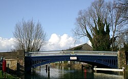
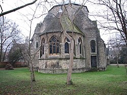
Botley Road

Last updated

View west along the Botley Road Botley Road - Oxford - geograph.org.uk - 313293.jpg
View west along the Botley Road
Osney Bridge, which carries the Botley Road, looking north from Osney Island OsneyBridge.jpg
Osney Bridge, which carries the Botley Road, looking north from Osney Island
St Frideswide's Church on Botley Road St Fridewides church - geograph.org.uk - 1102510.jpg
St Frideswide's Church on Botley Road
The railway bridge at the eastern end of the Botley Road The Botley Road rail bridge - geograph.org.uk - 1415944.jpg
The railway bridge at the eastern end of the Botley Road

Botley Road is the main road into the centre of Oxford, England from the west. [2] It stretches between Botley, on the Oxford Ring Road (A34) to the west of the city, and Frideswide Square at the junction with Oxford railway station, close to central Oxford.

Contents

Overview

The Botley Road was known as the Botley Turnpike Road in the 18th century and Seven Bridges Road in the 19th century. [2] Until the early 19th century it was little more than a track and highwaymen were a problem.

The road passes Osney. Out-of-town retail stores line the route. The road is designated as the A420. It becomes West Way at Botley Bridge over Seacourt Stream to the west. To the east, past the station, it becomes Park End Street. Oxpens Road leads off to the south at this junction. Along its route are several bridges — west to east: Botley Bridge, Bulstake Bridge, Osney Ditch Bridge, and Osney Bridge — as it passes over various sidechannels and the main branch of the River Thames.

Side streets, as well as most of the road between the railway station and the Beaumont veterinary practice, are mostly residential, and are flanked by two large parks (Botley Park, adjacent to West Oxford Community Centre, and Oatlands Park, near the Osney Mead industrial estate). The Botley Road is an important bus and commuter route to Oxford, and Seacourt Park and Ride is located near the junction with the A34.

Eastbound, it has a bus lane from the ring road until just before Osney Island, at which point there is a set of bus advancement traffic lights. It has cycle lanes in both directions. South from the eastern end, via Mill Street, are the site of Osney Abbey (now destroyed), Osney Cemetery (established 1848), Osney Lock, Osney Mill, and Osney Mill Marina.

Closure for station development

In October 2022, Network Rail said that Botley Road was likely to be closed at the railway station for the whole of 2023. [3] [4] In December 2022, Network Rail said they were looking at how to reduce the impact of the work on the local community and that they did not need to start the full closure of Botley Road in January 2023. [5] Under revised plans announced by Network Rail in March 2023, Botley Road is closed at the railway bridge from 11 April 2023 to allow utility services to divert their infrastructure under the bridge and undertake other enabling work. [6] The road was due to reopen from October 2023 to spring 2024 before closing again for the bridge to be replaced. [7] In September 2023, Network Rail said that, because of delays, it would remain closed until the work is completed in October 2024. [8]

Development

From the railway station:

The development of roads between Osney Island and Bullstake Stream started in the 1890s. Oatlands Meadow, owned by Morrell's Trustees, was first advertised in 1894. Thomas Gable, an Oxford publican, laid out Hill View Road in 1895, providing plots for others to develop. Thomas Gable died later that year and Kingerlee builders bought the unsold plots along the rest of Hill View Road. In 1901 they gained permission for a building estate extending from Alexandra Road to Riverside Road. The firm also acquired consent to develop the land north of Botley Road, and laid out Henry Road and Helen Road (named after Thomas Henry Kingerlee's eldest children) and part of Binsey Lane in 1902. Harley Road and Riverside Road were laid out in 1919, and built in the following few years. [9]

Quotations

Author and Oxford scholar C. S. Lewis mentions the road to Botley comically in his autobiography. Describing his first-ever arrival in Oxford as a young student, he writes:

"I sallied out of the railway station on foot to find either a lodging-house or a cheap hotel; all agog for dreaming spires and last enchantments. My first disappointment at what I saw could be dealt with. Towns always show their worst face to the railway. But as I walked on and on I became more bewildered. Could this succession of mean shops really be Oxford? But I still went on, always expecting the next turn to reveal the beauties, and reflecting that it was a much larger town than I had been led to suppose. Only when it became obvious that there was very little town left ahead of me, that I was in fact getting to open country, did I turn round and look. There behind me, far away, never more beautiful since, was the fabled cluster of spires and towers. I had come out of the station on the wrong side and been all this time walking into what was even then the mean and sprawling suburb of Botley." [10]

Crime novelist Colin Dexter writes:

"Beginning its life under a low (Head Room 12ft) railway bridge, and proceeding its cramped and narrow way for several hundred yards past shabby rows of terraced houses that line the thoroughfare in tight and mean confinement, the Botley Road gradually broadens into a spacious stretch of dual carriageway that carries all west-bound traffic towards Faringdon, Swindon and the sundry hamlets in between. Here the houses no longer shoulder their neighbours in such grudging proximity, and hither several of the Oxford businessmen have brought their premises." [11]

See also

Related Research Articles

<span class="mw-page-title-main">Botley, Oxfordshire</span> Human settlement in England

Botley is a village in the civil parish of Botley and North Hinksey, in the Vale of White Horse district, in the county of Oxfordshire, England, just west of the Oxford city boundary. Historically part of Berkshire, it stands on the Seacourt Stream, a stream running off the River Thames. The intersection of the A34 and A420 is to the village's north.

<span class="mw-page-title-main">North Hinksey</span> Human settlement in England

North Hinksey is a village in the civil parish of Botley and North Hinksey, in the Vale of White Horse district, in Oxfordshire, England, on the west side of the Thames flood plain immediately opposite the city of Oxford. The civil parish includes the large settlement of Botley, effectively an isolated suburb of Oxford, with the Botley Road as the sole highway link across the flood plain. North Hinksey was in all respects part of Berkshire until the 1974 boundary changes transferred administration of the Vale of White Horse district to Oxfordshire County Council; it remains part of the historic county of Berkshire however, since the 1974 act did not change the ancient county boundaries. The village of North Hinksey has a manor house, The Fishes public house, a Church of England primary school and a Church of England parish church, St. Lawrence's, which dates back to at least the 12th century. Four of the older houses have thatched roofs.

<span class="mw-page-title-main">Oxford railway station</span> Railway station in Oxfordshire, England

Oxford railway station is a mainline railway station, one of two serving the city of Oxford, England. It is about 0.5 miles (800 m) west of the city centre, north-west of Frideswide Square and the eastern end of Botley Road. It is on the line for trains between London Paddington and Hereford via Worcester Shrub Hill. It is a starting point for fast and local trains to London Paddington and London Marylebone, and for local trains to Reading, Worcester, and Banbury. It is also on the north/south Cross Country Route from Manchester Piccadilly and Newcastle via Birmingham New Street and Reading to Southampton Central and Bournemouth. The station is managed by Great Western Railway, and also served by CrossCountry and Chiltern Railways trains. Immediately to the north is Sheepwash Channel Railway Bridge over the Sheepwash Channel.

<span class="mw-page-title-main">Cherwell Valley line</span>

The Cherwell Valley line is the railway line between Didcot and Banbury via Oxford. It links the Great Western Main Line and the south to the Chiltern Main Line and the Midlands. The line follows the River Cherwell for much of its route between Banbury and Oxford.

<span class="mw-page-title-main">Binsey, Oxfordshire</span> Village in Oxfordshire, England

Binsey is a village and former civil parish in the Oxford district, in the county of Oxfordshire, England. It is the River Thames about 1.5 miles (2.4 km) northwest of the centre of Oxford, on the opposite side of the river from Port Meadow and about 1 mile (1.6 km) southwest of the ruins of Godstow Abbey. In 192 the parish had a population of 63.

<span class="mw-page-title-main">Osney</span> Human settlement in England

Osney or Osney Island is a riverside community in the west of the city of Oxford, England. In modern times the name is applied to a community also known as Osney Town astride Botley Road, just west of the city's main railway station, on an island surrounded by the River Thames, Osney Ditch and another backwater connecting the Thames to Osney Ditch.

<span class="mw-page-title-main">Osney Abbey</span> Abbey in Oxford, England

Osney Abbey or Oseney Abbey, later Osney Cathedral, was a house of Augustinian canons at Osney in Oxfordshire. The site is south of the modern Botley Road, down Mill Street by Osney Cemetery, next to the railway line just south of Oxford station. It was founded as a priory in 1129, becoming an abbey around 1154. It was dissolved in 1539 but was created a cathedral, the last abbot Robert King becoming the first Bishop of Oxford. The see was transferred to the new foundation of Christ Church in 1545 and the building fell into ruin. It was one of the four renowned monastic houses of medieval Oxford, along with St Frideswide's Priory, Rewley and Godstow.

The Oxford Ring Road circles the city of Oxford, England. It is a dual carriageway ring road for most of its length apart from a short section between Woodstock Road and Banbury Road in the north of the city. The severe restrictions on traffic in Oxford city centre mean that it is the only practical way for long-distance traffic to get past Oxford, especially as there are few road bridges over the rivers Isis and Cherwell. Five Park and Rides are close to the ring road.

<span class="mw-page-title-main">Hinksey Stream</span> Stream in Oxfordshire, England

Hinksey Stream is a branch of the River Thames to the west of the city of Oxford, England. It starts as Seacourt Stream, which leaves the Thames at a bifurcation north of the village of Wytham, and rejoins the river south of the city near Kennington.

<span class="mw-page-title-main">Osney Bridge</span> Bridge in Oxford

Osney Bridge is a road bridge across the River Thames in Oxford, England, built in 1888 to replace a stone bridge which collapsed in 1885. It carries the Botley Road (A420) from Botley into Oxford. The Thames Path crosses the river on this bridge, just above Osney Lock.

<span class="mw-page-title-main">Seacourt</span> Deserted medieval village in Oxfordshire, UK

<span class="mw-page-title-main">Frideswide Square</span> Square in Oxford, England

Frideswide Square is a square to the west of central Oxford, England. The square is named after the patron saint of Oxford, St Frideswide.

<span class="mw-page-title-main">Bulstake Stream</span> Stream in Oxfordshire, England

Bulstake Stream, also spelt Bullstake Stream, is a backwater of the River Thames at Oxford, England.

<span class="mw-page-title-main">Ferry Hinksey Road</span> Road in west Oxford, England

Ferry Hinksey Road is a road in west Oxford, England, leading south from the Botley Road. The road leads to the Osney Mead Industrial Estate to the east, started in 1961. To the east is Osney Ditch.

<span class="mw-page-title-main">Rewley Road Swing Bridge</span> Bridge in Oxford, England

Rewley Road Swing Bridge is a disused railway swing bridge over Sheepwash Channel in west Oxford, England. To the north are Cripley Meadow and Fiddler's Island and to the south are Osney Island and the Botley Road.

<span class="mw-page-title-main">Botley Bridge</span> Bridge in Oxford

Botley Bridge is a road bridge across Seacourt Stream, a branch of the River Thames in Oxford, England.

<span class="mw-page-title-main">Bulstake Bridge</span> Bridge in United Kingdom

Bulstake Bridge is a road bridge across the Bulstake Stream, a branch of the River Thames in Oxford, England.

<span class="mw-page-title-main">Osney Ditch</span>

The Osney Ditch is a side channel of the River Thames at Oxford, England. It is one of the principal watercourses in west Oxford.

References

  1. "St Frideswide's Church, Oxford". Church of England. Archived from the original on 4 May 2013. Retrieved 25 September 2012.
  2. 1 2 Hibbert, Christopher, ed. (1988). "Botley Road". The Encyclopaedia of Oxford . Macmillan. pp. 53–54. ISBN   0-333-39917-X.
  3. "Oxford: Network Rail says Botley Road could be shut for 2023". BBC News Online . 31 October 2022. Archived from the original on 20 December 2022. Retrieved 1 November 2022.
  4. "Oxford Corridor Phase 2". Network Rail . 31 October 2022. Archived from the original on 1 November 2022. Retrieved 1 November 2022. While there is still detailed work to be done to finalise our plans for what is a very complex project, the most likely scenario now is that the road under the bridge will be closed to all vehicles, apart from emergency services, for 12 months from January to December 2023.
  5. "Oxford Corridor Phase 2". Network Rail . 13 December 2022. Archived from the original on 13 December 2022. Retrieved 15 January 2023.
  6. "Botley Road in Oxford shuts for six months as £161m rail work begins". BBC News Online . 11 April 2023. Archived from the original on 23 April 2023. Retrieved 12 April 2023.
  7. "Oxford railway station: New schedule revealed for redevelopment". BBC News Online . 2 March 2023. Archived from the original on 13 March 2023. Retrieved 2 March 2023.
  8. "Botley Road closure extended due to 'unique challenges'". BBC News Online . 19 September 2023. Archived from the original on 19 September 2023. Retrieved 19 September 2023.
  9. "Welcome to Pearce Alder & Co Estate Agents". Pearcealder.com. Archived from the original on 27 August 2013. Retrieved 24 September 2013.
  10. C. S. Lewis. Surprised by Joy , 1955.
  11. Colin Dexter. Last Bus to Woodstock , 1975, page 69.

51°45′09″N1°16′57″W / 51.7526°N 1.2824°W / 51.7526; -1.2824