
The Shark Bay Marine Park is protected marine park located within the UNESCO World Heritage–listed Shark Bay, in the Gascoyne region of Western Australia. The 748,725-hectare (1,850,140-acre) marine park is situated over 800 km (500 mi) north of Perth and 400 kilometres (250 mi) north of Geraldton.

The subfamily Sminthopsinae includes several genera of small, carnivorous marsupials native to Australia: kultarrs, ningauis, dunnarts, and planigales.
The Marmion Marine Park is a protected area along and off the coast of northern Perth, Western Australia.

The Shoalwater Islands Marine Park is a protected marine park located in Western Australia and stretches from the northern point of the Garden Island Causeway to the southern point of Becher Point. The 6,540-hectare (16,200-acre) marine park is located offshore from the suburban locality of Shoalwater.
The Boullanger Island dunnart is a species of dunnart found only on Boullanger Island, Western Australia. It was formerly considered a subspecies of the grey-bellied dunnart, for which reason it was not assessed by the IUCN in 2008. The EPBC Act classifies the Boullanger Island dunnart as vulnerable.

Wedge Island is a 400-metre long wedge shaped island north of Lancelin and south of Cervantes on the Western Australian coast. The island is located just south of “the point” and approximately 15km south-east of an informal settlement known as Grey village with which it often shares a name. Both are within the Shire of Dandaragan.

The Jurien Bay Marine Park is a protected marine park that is located 200 to 300 kilometres north of Perth, off the coastal tip of the Wheatbelt region of Western Australia. The 82,375-hectare (203,550-acre) marine park was formally declared on 31 August 2003 and is situated along the Indian Ocean Drive that extends south from Green Head to the southern boundary of Nambung National Park. It includes many of the islands located in this region.
Dragon Rocks is a 322 km2 nature reserve in the south-east of the Wheatbelt region of Western Australia, some 310 km east-south-east of Perth. It is surrounded by farmland. It is listed on Australia's Register of the National Estate as an area significant for rare species of plants and animals.
Great Sandy Island is an island between Onslow and Dampier, off the Pilbara coast of Western Australia. It has an area of about 32 hectares. Great Sandy Island is located in the Great Sandy Island Nature Reserve, which was declared in 1968.

Seal Island is located near Shoalwater, Western Australia in the Perth region.

Escape Island is an island near Jurien Bay in Western Australia. It is located within the Jurien Bay Marine Park and part of the Escape Island Nature Reserve.
Whitlock Island is an island near Jurien Bay in Western Australia. It is located within the Jurien Bay Marine Park and part of the Boullanger, Whitlock, Favourite, Tern and Osprey Islands Nature Reserve.

Favorite Island is an island near Jurien Bay in Western Australia.
The Cervantes Islands are a small group of islands to the south-west of the locality of Cervantes, both within the Shire of Dandaragan in Western Australia. They are 2 kilometres (1.2 mi) from Thirsty Point at the southern side of the locality, approximately 180 kilometres (110 mi) north-west of Perth.
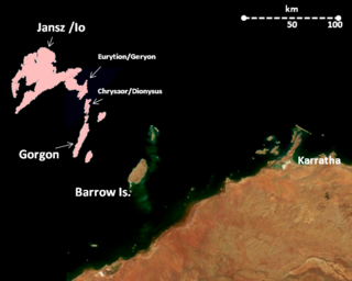
The Montebello Island Marine Park is located off the northwest coast of Western Australia, about 1,600 km north of Perth, and 120 km west of Dampier. The reserve includes the entire group of Montebello Islands.
Jane National Park is a national park in the South West region of Western Australia, 357 km (222 mi) south of Perth. It is located adjacent to the west of the much larger Shannon National Park, in the Shire of Manjimup. It is located in the Warren bioregion.
Easter National Park is a national park in the South West region of Western Australia, 294 km (183 mi) south of Perth. It is located adjacent to the east of the much larger Hilliger and Milyeannup national parks, in the Shire of Nannup. The majority of the national park is located east of the Vasse Highway. It is located in the Jarrah Forest and Warren bioregions.
Milyeannup National Park is a national park in the South West region of Western Australia, 309 km (192 mi) south of Perth. It is located in the Shire of Nannup, bordering the Hilliger National Park. The park is located in the Jarrah Forest bioregion.

