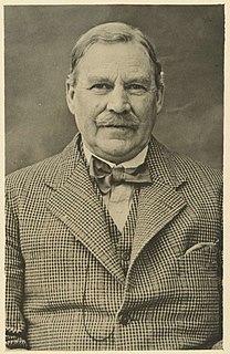
Will H. Ogilvie was a Scottish-Australian narrative poet and horseman, jackaroo, and drover, and described as a quiet-spoken handsome Scot of medium height, with a fair moustache and red complexion. He was also known as Will Ogilvie, by the pen names including 'Glenrowan' and the lesser 'Swingle-Bar', and by his initials, WHO.
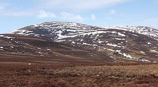
The Cheviot is an extinct volcano and the highest summit in the Cheviot Hills and in the county of Northumberland. Located in the extreme north of England, it is 1+1⁄4 miles from the Scottish border and is the last major peak on the Pennine Way, if travelling from south to north, before the descent into Kirk Yetholm.

Denholm is a small village located between Jedburgh and Hawick in the Scottish Borders region of Scotland, UK. The estimated population of Denholm is 600. There is a village green in the centre. It lies in the valley of the River Teviot. Denholm is a Conservation Area listed as 'a planned village as opposed to the traditional unplanned or organic form of village usually found in Roxburghshire.'
Longstone is a suburb of Edinburgh in Scotland. The area is primarily residential in nature, although the area includes several small shops, eateries and supermarkets, as well as one of the main bus depots for the city's buses. The population of Longstone was 4,678 in 2019.

Mindrum is a village in Northumberland, England, in the district of Berwick-upon-Tweed. Now little more than a postal address, it forms the centre of a number of farms.

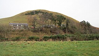
Town Yetholm is a small village in the Scottish Borders in the valley of the Bowmont Water opposite Kirk Yetholm. The centre of the small village is made up of the village green surrounded by the village shop, the Plough Hotel Public House a few houses to the south and a row of terraced dwellings to the north, separated from the green by the Main Street. The Wauchope Hall is situated at the east end of the main street next to Gibsons Garage. The village has many notable houses with impressive views.

Garvald is a hamlet on the B7007, near Dewar, by the Dewar Burn, in the Moorfoot Hills, in the Scottish Borders area of Scotland, in the former Peeblesshire.
Baddinsgill Reservoir is a small reservoir in the Scottish Borders area of Scotland close to Carlops, West Linton, and the boundary with Midlothian. It is close to Baddinsgill House. The Lyne Water is dammed to form the reservoir, not the Baddinsgill Burn, which joins the Lyne Water further south, below the reservoir. The earth dam was faced with concrete blocks. In time these eroded and they were capped with 100 millimetres (3.9 in) of tarmac.

Legerwood is a village by the Eden Water, in the Scottish Borders area of Scotland, near Lauder, near the Southern Upland Way.

The Kale Water is a 20 miles (32 km) long tributary of the River Teviot in the Scottish Borders area of Scotland. Its feeder burns in the Cheviot Hills are the Long Burn, Hawkwillow Burn and the Grindstone Burn, east of Leithope Forest near the Anglo-Scottish Border.
Mowhaugh is a hamlet and farm steading near the Calroust Burn and the Bowmont Water, near Morebattle, in the Scottish Borders area of Scotland, and in the former Roxburghshire. It is situated about 5 miles (8 km) from the Anglo-Scottish Border.

Liddel Castle is a ruined castle in Liddesdale, by the Liddel Water, near Castleton in the Scottish Borders area of Scotland, in the former county of Roxburghshire. Liddel Castle is a scheduled monument.

The Hermitage Water is a river in Liddesdale, in the Scottish Borders area of Scotland. Among its many feeder burns are Braidley Burn, Dinley Burn, Gorrenberry Burn and Twislehope Burn. The Water flows through the hamlets of Dinley and Gorrenberry, and through the village of Hermitage, and past Hermitage Castle. It continues past Toftholm where it meets the B6399, and passes Newlands, Longhaugh, Leahaugh and Redheugh. At Sandholm it joins the Liddel Water and the dismantled railway.

Yetholm Loch is a loch near Kelso, in the Scottish Borders area of Scotland, in the former Roxburghshire. It is also a nature reserve of the Scottish Wildlife Trust, bearing the same name.

The Cheviot Hills, or sometimes The Cheviots, are a range of uplands straddling the Anglo-Scottish border between Northumberland and the Scottish Borders. The English section is within the Northumberland National Park. The range includes The Cheviot, plus Hedgehope Hill to the east, Windy Gyle to the west, and Cushat Law and Bloodybush Edge to the south.

Kilham is a hamlet and civil parish in the English county of Northumberland, located 8.0 miles (12.9 km) west of Wooler, 12.0 miles (19.3 km) east of Kelso, 17.0 miles (27.4 km) south west of Berwick upon Tweed and 38.9 miles (62.6 km) north west of Morpeth. It lies on the northern edge of the Northumberland National Park in Bowmont Valley Northumberland]. The hamlet, which consists of a small group of agricultural dwellings, is overlooked by Kilham Hill and the northern limits of the Cheviot Hills. The parish had a population of 131 in 2001, and includes the hamlets of Howtel and Pawston, along with the former upland township of Coldsmouth and Thompson's Walls. falling to less than 100 at the 2011 Census. Details are now included in the parish of Branxton
Kelso High School is a state-funded comprehensive secondary school in Kelso, Scotland, under the control of the Scottish Borders Council. It is one of nine secondary schools in the Scottish Borders and the only one in Kelso. Pupils come to Kelso High School from the town of Kelso, the villages of Ednam, Eckford, Stichill, Smailholm, Morebattle, Roxburgh, Yetholm and other hamlets in the surrounding area. The current building was opened to students in November 2017.

Sprouston is a village, parish and former feudal barony in the Scottish Borders area of Scotland, as well as the historic county of Roxburghshire, located 2 miles north-east of Kelso.
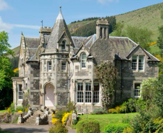
The Kirna, known locally as Kirna House, is a Category A listed villa in Walkerburn, Peeblesshire, Scotland. It is one of four villas in Walkerburn designed by Frederick Thomas Pilkington between 1867-69 for the Ballantyne family. It is listed as a fine example of a Pilkington mansion retaining original external features, a fine interior, and for its importance as a Ballantyne property.