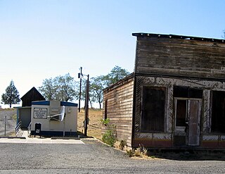
Antelope is a small town in Wasco County, Oregon, United States. It has an estimated population of 47 people, and is incorporated as a city. The town was incorporated in 1901, though it was founded earlier. The City of Antelope was originally a stage and freight wagon road stop on the Old Dalles to Canyon City Trail. Howard Maupin came to Antelope in 1863 to operate a horse ranch, becoming the caretaker of the stage station which was established by Henry Wheeler in 1864. Maupin began raising cattle to provide meat for travelers. Nathan Wallace, who is sometimes credited with being Antelope's first postmaster, acquired the Antelope stage station from Maupin in 1870. Records indicate the community was considered to have been established in 1872.

Maupin is a city in Wasco County, Oregon, United States. Located on the Deschutes River, much of the city's economy is related to the river through outdoor activities, such as fishing and rafting. The population was 418 at the 2010 census.
Wishram is an unincorporated community and census-designated place (CDP) in Klickitat County, Washington, United States. The population was 342 at the 2010 census, up from 213 at the 2000 census. The site of the historic Celilo Falls is nearby.

The Deschutes River in central Oregon is a major tributary of the Columbia River. The river provides much of the drainage on the eastern side of the Cascade Range in Oregon, gathering many of the tributaries that descend from the drier, eastern flank of the mountains. The Deschutes provided an important route to and from the Columbia for Native Americans for thousands of years, and then in the 19th century for pioneers on the Oregon Trail. The river flows mostly through rugged and arid country, and its valley provides a cultural heart for central Oregon. Today the river supplies water for irrigation and is popular in the summer for whitewater rafting and fishing.

The Grand Trunk Western Railroad Company is an American subsidiary of the Canadian National Railway operating in Michigan, Illinois, Indiana, and Ohio. Since a corporate restructuring in 1971, the railroad has been under CN's subsidiary holding company, the Grand Trunk Corporation. Grand Trunk Western's routes are part of CN's Michigan Division. Its primary mainline between Chicago and Port Huron, Michigan serves as a connection between railroad interchanges in Chicago and rail lines in eastern Canada and the Northeastern United States. The railroad's extensive trackage in Detroit and across southern Michigan has made it an essential link for the automotive industry as a hauler of parts and automobiles from manufacturing plants.

The St. Lawrence and Atlantic Railroad, known as St-Laurent et Atlantique Quebec in Canada, is a short-line railway operating between Portland, Maine, on the Atlantic Ocean, and Montreal, Quebec, on the St. Lawrence River. It crosses the Canada–US border at Norton, Vermont, and Stanhope, Quebec, and is owned by short-line operator Genesee & Wyoming.

The Spokane, Portland & Seattle Railway (SP&S) was a railroad in the northwest United States. Incorporated in 1905, it was a joint venture by the Great Northern Railway and the Northern Pacific Railway to build a railroad along the north bank of the Columbia River. Remnants of the line are currently operated by BNSF Railway and the Portland and Western Railroad.
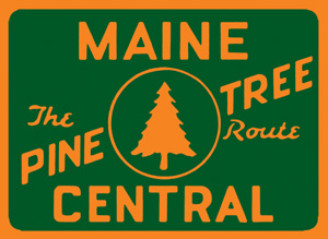
The Maine Central Railroad Company was a former U. S. Class I railroad in central and southern Maine. It was chartered in 1856 and began operations in 1862. By 1884, Maine Central was the longest railroad in New England. Maine Central had expanded to 1,358 miles (2,185 km) when the United States Railroad Administration assumed control in 1917. The main line extended from South Portland, Maine, east to the Canada–United States border with New Brunswick, and a Mountain Division extended west from Portland to Vermont and north into Quebec. The main line was double track from South Portland to Royal Junction, where it split into a "lower road" through Brunswick and Augusta and a "back road" through Lewiston which converged at Waterville into single track to Bangor and points east. Branch lines served the industrial center of Rumford, a resort hotel on Moosehead Lake, and coastal communities from Bath to Eastport.

The Portland and Western Railroad is a 466-mile (750 km) Class II railroad serving the U.S. state of Oregon, and is a wholly owned subsidiary of shortline and regional railroad holding company Genesee & Wyoming Inc. The PNWR includes a subsidiary, the Willamette and Pacific Railroad.
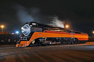
Southern Pacific 4449, also known as the "Daylight", is the only surviving example of Southern Pacific Railroad's GS-4 class of steam locomotives and one of only two GS-class locomotives surviving, the other being GS-6 4460 at the Museum of Transportation in St. Louis, Missouri. The locomotive is a streamlined 4-8-4 "Northern" type steam locomotive. GS is abbreviated from "Golden State", a nickname for California, or "General Service".

The Oregon, Pacific and Eastern Railway is an Oregon-based short line railroad that began near Eugene as the Oregon and Southeastern Railroad (O&SE) in 1904. O&SE's line ran 18 miles (29 km) along the Row River between the towns of Cottage Grove and Disston. The Oregon, Pacific & Eastern Railway Company incorporated in 1912, purchased the physical assets of the O&SE two years later, and shortened their total trackage to operate 16.6 miles (26.7 km) from an interchange yard with the Southern Pacific Railroad at Cottage Grove, east to a 528' x 156' turnaround loop at Culp Creek. The last of this track was closed and scrapped in 1994, and ownership of its abandoned right of way property was later reverted to the state of Oregon to become one of the first-ever Government/Private Sector cooperative partnership Rails to Trails programs in the US, forming the Row River National Recreation Trail. A successor corporation now operates a narrow-gauge line at Wildlife Safari.

Oregon Route 216 is an Oregon state highway running from U.S. Route 26 at Warm Springs Junction to U.S. Route 97 in Grass Valley. OR 216 is 61.30 miles (98.65 km) long and runs east–west.

5 ft 6 in / 1,676 mm, a broad gauge, is the track gauge used in India, Pakistan, western Bangladesh, Sri Lanka, Argentina, Chile, and on BART in the San Francisco Bay Area.

Cline Falls State Scenic Viewpoint is a state park near Redmond, Oregon, United States. It is located on the Deschutes River. The park covers 9 acres (36,000 m2). It is administered by the Oregon Parks and Recreation Department.
Howard Maupin (1815–1887) was an American settler who established a farm and ferry in Oregon at the present-day location of Maupin. He became famous for shooting the Paiute war leader Chief Paulina on April 25, 1867, near the modern town of Madras.

The Oregon Pony was the first steam locomotive to be built on the Pacific Coast and the first to be used in the Oregon Territory. The locomotive, a geared steam 5' gauge locomotive with 9"X18" cylinders and 34" drivers, was used in the early 1860s to portage steamboat passengers and goods past the Cascades Rapids, a dangerous stretch of the Columbia River now drowned by the Bonneville Dam. Steamboats provided transportation on the Columbia between Portland, Oregon and mining areas in Idaho and the Columbia Plateau. Portage was also necessary at other navigation obstructions, including Celilo Falls.
The Crooked River Railroad Bridge, part of a BNSF Railway line between the Columbia River and Bend, Oregon, crosses Oregon's Crooked River Canyon in southern Jefferson County. The bridge is 320 feet (98 m) above the river and when it was completed in 1911, it was the second-highest railroad bridge in the United States. It is a steel two-hinge arch span with a total length of 460 feet (140 m).

Dant is an unincorporated community in Wasco County, in the U.S. state of Oregon. It lies along the west bank of the Deschutes River between the north border of the Warm Springs Indian Reservation and the small city of Maupin, north of the Mutton Mountains. Dant is not on a paved or numbered highway.
South Junction is an unincorporated community in Wasco County, in the U.S. state of Oregon. It lies at the west end of South Junction Road on the east bank of the Deschutes River across from the mouth of the Warm Springs River. The road connects South Junction with Shaniko Junction to the northeast, where U.S. Route 97 and U.S. Route 197 intersect.
Pringle Falls is a series of rapids or drops on the upper Deschutes River in the U.S. state of Oregon. From just downstream of Wyeth Campground, the rapids begin with about 600 feet (180 m) of whitewater rated class II (novice) on the International Scale of River Difficulty. The next 300 feet (91 m) is class III (intermediate] ending in a class IV drop. Soggy Sneakers: A Paddler's Guide to Oregon's Rivers says, "Only expert kayakers should consider this drop, and only after scouting. It is definitely not a rapids for open canoes."