Boyd, Minnesota

Last updated

Boyd
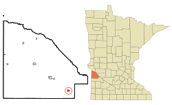
Lac qui Parle County Minnesota Incorporated and Unincorporated areas Boyd Highlighted.svg
Location of Boyd, Minnesota
Coordinates: 44°51′04″N95°54′03″W / 44.85111°N 95.90083°W / 44.85111; -95.90083
Country United States
State Minnesota
County Lac qui Parle
Area
[1]
  Total0.51 sq mi (1.32 km2)
  Land0.51 sq mi (1.32 km2)
  Water0.00 sq mi (0.00 km2)
Elevation
[2]
1,050 ft (320 m)
Population
 (2020)
  Total141
  Density275.93/sq mi (106.53/km2)
Time zone UTC-6 (Central (CST))
  Summer (DST) UTC-5 (CDT)
ZIP code
56218
Area code 320
FIPS code 27-07138 [3]
GNIS feature ID2394232 [2]
Website www.dawsonboydschools.org

Boyd is a city in Lac qui Parle County, Minnesota, United States. The population was 175 at the 2010 census. [4]

Contents

History

Boyd was platted in 1884. [5] A post office has been in operation at Boyd since 1884. [6] The city was incorporated in 1893. [5]

Geography

According to the United States Census Bureau, the city has a total area of 0.52 square miles (1.35 km2), all land. [7]

Demographics

Historical population
CensusPop.Note
1900 335
1910 43128.7%
1920 54927.4%
1930 449−18.2%
1940 52316.5%
1950 496−5.2%
1960 419−15.5%
1970 311−25.8%
1980 3295.8%
1990 251−23.7%
2000 210−16.3%
2010 175−16.7%
2020 141−19.4%
U.S. Decennial Census [8]

2010 census

As of the census [9] of 2010, there were 175 people, 88 households, and 43 families living in the city. The population density was 336.5 inhabitants per square mile (129.9/km2). There were 114 housing units at an average density of 219.2 per square mile (84.6/km2). The racial makeup of the city was 94.9% White, 0.6% Asian, and 4.6% from other races. Hispanic or Latino of any race were 4.6% of the population.

There were 88 households, of which 17.0% had children under the age of 18 living with them, 37.5% were married couples living together, 4.5% had a female householder with no husband present, 6.8% had a male householder with no wife present, and 51.1% were non-families. 43.2% of all households were made up of individuals, and 17% had someone living alone who was 65 years of age or older. The average household size was 1.99 and the average family size was 2.63.

The median age in the city was 49.2 years. 17.7% of residents were under the age of 18; 7.4% were between the ages of 18 and 24; 19.4% were from 25 to 44; 34.9% were from 45 to 64; and 20.6% were 65 years of age or older. The gender makeup of the city was 56.0% male and 44.0% female.

2000 census

As of the census [3] of 2000, there were 210 people, 100 households, and 52 families living in the city. The population density was 393.5 inhabitants per square mile (151.9/km2). There were 116 housing units at an average density of 217.4 per square mile (83.9/km2). The racial makeup of the city was 97.62% White, 1.43% Native American and 0.95% Asian.

There were 100 households, out of which 18.0% had children under the age of 18 living with them, 42.0% were married couples living together, 7.0% had a female householder with no husband present, and 48.0% were non-families. 39.0% of all households were made up of individuals, and 16.0% had someone living alone who was 65 years of age or older. The average household size was 2.10 and the average family size was 2.88.

In the city, the population was spread out, with 19.0% under the age of 18, 8.1% from 18 to 24, 30.5% from 25 to 44, 27.1% from 45 to 64, and 15.2% who were 65 years of age or older. The median age was 42 years. For every 100 females, there were 103.9 males. For every 100 females age 18 and over, there were 107.3 males.

The median income for a household in the city was $30,625, and the median income for a family was $41,500. Males had a median income of $21,591 versus $17,955 for females. The per capita income for the city was $16,917. About 4.0% of families and 6.8% of the population were below the poverty line, including none of those under the age of eighteen and 5.4% of those 65 or over.
Related Research Articles

<span class="mw-page-title-main">Ramsey, Minnesota</span> City in Minnesota, United States

Ramsey is a suburb 22 miles north-northwest of downtown Minneapolis in Anoka County, Minnesota, United States. The population was 27,646 at the 2020 census. It is a northwest suburb of the Twin Cities.

Akron Township is a township in Big Stone County, Minnesota, United States. The population was 196 as of the 2000 census.

<span class="mw-page-title-main">Lake Shore, Minnesota</span> City in Minnesota, United States

Lake Shore is a city in Cass County, Minnesota, United States. The population was 1,056 at the 2020 census. It is part of the Brainerd Micropolitan Statistical Area.

<span class="mw-page-title-main">Hitterdal, Minnesota</span> City in Minnesota, United States

Hitterdal is a city in Clay County, Minnesota, United States. The population was 199 at the 2020 census.

<span class="mw-page-title-main">Warba, Minnesota</span> City in Minnesota, United States

Warba is a city in Itasca County, Minnesota, United States. The population was 181 at the 2010 census.

<span class="mw-page-title-main">Bellingham, Minnesota</span> City in Minnesota, United States

Bellingham is a city in Lac qui Parle County, Minnesota, United States. The population was 168 at the 2010 census.

<span class="mw-page-title-main">Dawson, Minnesota</span> City in Minnesota, United States

Dawson is a city in Lac qui Parle County, Minnesota, United States. The population was 1,466 at the 2020 census.

Garfield Township is a township in Lac qui Parle County, Minnesota, United States. The population was 187 at the 2000 census.

Hantho Township is a township in Lac qui Parle County, Minnesota, United States. The population was 154 at the 2000 census.

<span class="mw-page-title-main">Louisburg, Minnesota</span> Hamlet in Minnesota, United States

Louisburg is a very small, unincorporated town in Lac qui Parle County, Minnesota, United States. The population was 47 at the 2010 census.

<span class="mw-page-title-main">Marietta, Minnesota</span> City in Minnesota, United States

Marietta is a city in Lac qui Parle County, Minnesota, United States on Minnesota State Highway 40 near the South Dakota border. The population was 162 at the 2010 census.

<span class="mw-page-title-main">Nassau, Minnesota</span> City in Minnesota, United States

Nassau is a city in Lac qui Parle County, Minnesota, United States. The population was 72 at the 2010 census.

Riverside Township is a township in Lac qui Parle County, Minnesota, United States. The population was 301 at the 2000 census.

<span class="mw-page-title-main">Erhard, Minnesota</span> City in Minnesota, United States

Erhard is a city in Otter Tail County, Minnesota, United States. The population was 132 at the 2020 census.

<span class="mw-page-title-main">Sturgeon Lake, Minnesota</span> City in Minnesota, United States

Sturgeon Lake is a city in Pine County, Minnesota, United States. The population was 439 at the 2010 census.

<span class="mw-page-title-main">Lowry, Minnesota</span> City in Minnesota, United States

Lowry is a city in Pope County, Minnesota, United States. The population was 334 at the 2020 census.

<span class="mw-page-title-main">Revere, Minnesota</span> City in Minnesota, United States

Revere is a city in Redwood County, Minnesota, United States. The population was 95 at the 2010 census.

<span class="mw-page-title-main">Kimball, Minnesota</span> City in Minnesota, United States

Kimball is a city in Stearns County, Minnesota, United States. The population was 799 at the 2020 census. It is part of the St. Cloud Metropolitan Statistical Area.

<span class="mw-page-title-main">St. Leo, Minnesota</span> City in Minnesota, United States

St. Leo or Saint Leo is a city in Yellow Medicine County, Minnesota, United States. The population was 100 at the 2010 census.

Arena Township is a township in Lac qui Parle County, Minnesota, United States. The population was 153 at the 2000 census.

References

  1. "2020 U.S. Gazetteer Files". United States Census Bureau. Retrieved July 24, 2022.
  2. 1 2 U.S. Geological Survey Geographic Names Information System: Boyd, Minnesota
  3. 1 2 "U.S. Census website". United States Census Bureau . Retrieved January 31, 2008.
  4. "2010 Census Redistricting Data (Public Law 94-171) Summary File". American FactFinder. United States Census Bureau . Retrieved April 27, 2011.[ dead link ]
  5. 1 2 Warren Upham (1920). Minnesota Geographic Names: Their Origin and Historic Significance. Minnesota Historical Society. p.  289.
  6. "Lac qui Parle County". Jim Forte Postal History. Retrieved July 17, 2015.
  7. "US Gazetteer files 2010". United States Census Bureau. Archived from the original on January 25, 2012. Retrieved November 13, 2012.
  8. "Census of Population and Housing". Census.gov. Retrieved June 4, 2015.
  9. "U.S. Census website". United States Census Bureau . Retrieved November 13, 2012.