Atahualpa, also Atawallpa (Quechua), Atabalica, Atahuallpa, Atabalipa, was the last effective Incan emperor before his capture and execution during the Spanish conquest.

Huayna Capac was the third Sapa Inca of Tawantinsuyu, the Inca Empire. He was the son of and successor to Túpac Inca Yupanqui., the sixth Sapa Inca of the Hanan dynasty, and eleventh of the Inca civilization. He was born in Tumipampa and tutored to become Sapa Inca from a young age.

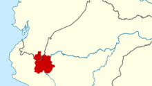
Zamora Chinchipe, Province of Zamora Chinchipe is a province of the Republic of Ecuador, located at the southeastern end of the Amazon Basin, which shares borders with the Ecuadorian provinces of Azuay and Morona Santiago to the north, Loja and Azuay to the west, and with Peru to the east and south. The province comprises an area of approximately 10,559 km² and is covered with a uniquely mountainous topography which markedly distinguishes it from the surrounding Amazonian provinces. Zamora-Chinchipe is characterized and largely identified by its mining industry; indigenous ethnic groups with a rich archaeological legacy; its biodiversity; and its niche and tourist attractions, which include a number of waterfalls well-noted for their beauty. The province takes its name from the bureaucratic fusion of the Zamora and Chinchipe cantons. The provincial capital is the city of Zamora.

The Second Ecuadorian–Peruvian War, known locally as the War of '41, was a South American border war fought between 5–31 July 1941. It was the first of three military conflicts between Ecuador and Peru during the 20th century.
Jaén, founded as San Leandro de Jaén and then known as Jerez de la Frontera and finally as Jaén de Bracamoros since April 1549, is a city which is the capital of the Jaén Province in the Cajamarca Region in Peru, located in the high jungle of northern Peru. It is the seat of the Catholic Apostolic Vicariate of St. Francis Xavier, also known as Apostolic Vicariate of Jaén en Peru.

The Ecuadorian–Peruvian territorial dispute was a territorial dispute between Ecuador and Peru, which, until 1928, also included Colombia. The dispute had its origins on each country's interpretation of what Real Cedulas Spain used to precisely define its colonial territories in the Americas. After independence, all of Spain's colonial territories signed and agreed to proclaim their limits in the basis of the principle of uti possidetis juris, which regarded the Spanish borders of 1810 as the borders of the new republics. However, conflicting claims and disagreements between the newly formed countries eventually escalated to the point of armed conflicts on several occasions.
The Chinchipe River is a river on the border between Ecuador and Peru. It rises in Ecuador, in the Zamora-Chinchipe Province, in the Podocarpus National Park. Then it flows through the Piura Region, and the Cajamarca Region in the San Ignacio Province of Peru. The river flows into the Maranon River.
Pimpingos District is one of fifteen districts of the Cutervo Province in the Cajamarca Region in Peru. It was created on 22 October 1910 by Law No. 1296. It is one of the oldest districts of the province.

Pre-Columbian Ecuador included numerous indigenous cultures, who thrived for thousands of years before the ascent of the Incan Empire. Las Vegas culture of coastal Ecuador, flourishing between 8000 and 4600 BC, is one of the oldest cultures in the Americas. The subsequent Valdivia culture in the Pacific coast region is another well-known early Ecuadorian culture. Ancient Valdivian artifacts from as early as 3500 BC have been found along the coast north of the Guayas Province in the modern city of Santa Elena.

Amazonian Kichwas are a grouping of indigenous Kichwa peoples in the Ecuadorian Amazon, with minor groups across the borders of Colombia and Peru. Amazonian Kichwas consists of different ethnic peoples, including Napo Kichwa and Canelos Kichwa. There are approximately 419 organized communities of the Amazonian Kichwas. The basic socio-political unit is the ayllu. The ayllus in turn constitute territorial clans, based on common ancestry. Unlike other subgroups, the Napo Kichwa maintain less ethnic duality of acculturated natives or Christians.

The Marañón River basin, at a low point in the Andes which made it an attractive location for trade between the Inca Empire and the Amazon basin, once harbored numerous languages which have been poorly attested or not attested at all. Those of the middle reaches of the river, above the Amazon basin, were replaced in historical times by Aguaruna, a Jivaroan language from the Amazon which is still spoken there. The languages further upriver are difficult to identify, due to lack of data. The region was multilingual at the time of the Conquest, and the people largely switched to Spanish rather than to Quechua, though Quechua also expanded during Colonial times.
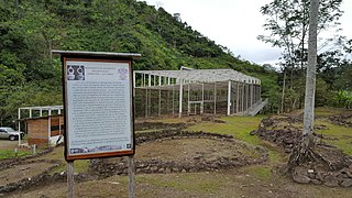
Santa Ana (La Florida) is an important archaeological site in the highlands of Ecuador, going back as early as 3,500 BC. It is located in the Palanda Canton, just to the north of its regional capital of es:Palanda, in the Zamora-Chinchipe Province of Ecuador.

The Saraguro is a people of the Kichwa nation most of whom live in Saraguro Canton in the Loja Province of Ecuador. Although most now speak Spanish, Runashimi or Kichwa, a Quechua dialect, is also spoken and language revitalization efforts are being implemented. Likewise, the Saraguro have retained much of their land, customs and traditional dress. According to the INEC's 2010 population census, the total population of Saraguro canton is 30,183, but that total includes both the Indigenous and non-Indigenous people living in Saraguro.

The Mayo-Chinchipe culture existed from c. 5500 – 1700 BCE in the highlands of what is now Ecuador.

Juan de Salinas y Loyola was a Spanish discoverer, conqueror and hidalgo belonging to the Alava branch of the House of Hoñaz y Loyola of Azpeitia. He was the governor of Yaguarzongo and Bracamoros and the adelantado of these provinces between 1571 and 1578.
Montegrande is an archaeological site in the Cajamarca department of Jaén province in Jaén District, Peru, a spiral temple or enclosure built c. 3000 BCE, by a culture that overlapped the current border with Ecuador. At 5000 years old, the site is as old as Caral. The site is located at the outskirts of the town of Jaén, Peru.

The Monument to the Defenders of the Border is a commemorative sculptural complex located in the Campo de Marte in Lima, Peru. Its author was the Peruvian sculptor Artemio Ocaña. It was erected between 1944 and 1945 in honor of those who fell during the Ecuadorian–Peruvian War of 1941.

The Governorate of Maynas, also known as the Province of Maynas, was one of the provinces established at the eastern part of the Real Audiencia of Quito during the 17th century, first as part of the Viceroyalty of Peru and later as part of the Viceroyalty of New Granada until its reincorporation to Peru through the real cédula of July 15, 1802, as the General Command of Maynas.
The Governorate of Quijos, also known unofficially as the Province of the Quijos prior to 1577, was one of the provinces established at the eastern part of the Real Audiencia of Quito during in 1559, varying between the Viceroyalties of Peru and New Granada until its ultimate reincorporation to Peru through the real cédula of July 15, 1802, as part of the General Command of Maynas.
The Governorate of Bracamoros was a governorate (gobernación) of the Spanish Empire established during the 16th century in an area of the Amazon rainforest originally populated by the now extinct Bracamoros people.