Braceville | |
---|---|
Coordinates: 41°13′27″N88°15′55″W / 41.22417°N 88.26528°W | |
Country | United States |
State | Illinois |
County | Will, Grundy |
Government | |
• Mayor | Dave Wright[ citation needed ] |
Area | |
• Total | 3.34 sq mi (8.65 km2) |
• Land | 3.11 sq mi (8.06 km2) |
• Water | 0.23 sq mi (0.59 km2) |
Elevation | 594 ft (181 m) |
Population (2020) | |
• Total | 724 |
• Density | 232.72/sq mi (89.85/km2) |
Time zone | UTC-6 (CST) |
• Summer (DST) | UTC-5 (CDT) |
Area code(s) | 815 & 779 |
FIPS code | 17-07640 |
GNIS feature ID | 2398160 [2] |
Wikimedia Commons | Braceville, Illinois |
Braceville is a village in Will County, Illinois, United States, with a portion in Grundy County. The population was 724 at the 2020 census. [3]
Braceville was founded under the name "Sulphur Springs" by Reverend L. S. Robbins in 1834. In 1848, after Robbin's death, the town elected its first official supervisor, B. R. Dowd, who changed the name to Braceville after his home town of Braceville Township, Ohio. When coal was discovered in the region, residents became interested in the mining industry. However, no mines have ever been opened, and gradually, the town shifted its focus on other industries. The population has fluctuated over time, but is now growing at a steady rate. [4]
According to the 2021 census gazetteer files, Braceville has a total area of 3.34 square miles (8.65 km2), of which 3.11 square miles (8.05 km2) (or 93.17%) is land and 0.23 square miles (0.60 km2) (or 6.83%) is water. [5]
Census | Pop. | Note | %± |
---|---|---|---|
1880 | 278 | — | |
1890 | 2,150 | 673.4% | |
1900 | 1,669 | −22.4% | |
1910 | 971 | −41.8% | |
1920 | 303 | −68.8% | |
1930 | 219 | −27.7% | |
1940 | 321 | 46.6% | |
1950 | 384 | 19.6% | |
1960 | 558 | 45.3% | |
1970 | 668 | 19.7% | |
1980 | 721 | 7.9% | |
1990 | 587 | −18.6% | |
2000 | 792 | 34.9% | |
2010 | 793 | 0.1% | |
2020 | 724 | −8.7% | |
U.S. Decennial Census [6] |
As of the 2020 census [3] there were 724 people, 288 households, and 202 families residing in the village. The population density was 216.83 inhabitants per square mile (83.72/km2). There were 308 housing units at an average density of 92.24 per square mile (35.61/km2). The racial makeup of the village was 91.71% White, 0.14% African American, 0.14% Native American, 0.14% Asian, 0.00% Pacific Islander, 1.80% from other races, and 6.08% from two or more races. Hispanic or Latino of any race were 4.83% of the population.
There were 288 households, out of which 33.7% had children under the age of 18 living with them, 60.07% were married couples living together, 8.68% had a female householder with no husband present, and 29.86% were non-families. 23.26% of all households were made up of individuals, and 7.99% had someone living alone who was 65 years of age or older. The average household size was 3.77 and the average family size was 3.08.
The village's age distribution consisted of 37.2% under the age of 18, 4.5% from 18 to 24, 22.2% from 25 to 44, 22.6% from 45 to 64, and 13.3% who were 65 years of age or older. The median age was 34.7 years. For every 100 females, there were 164.5 males. For every 100 females age 18 and over, there were 138.6 males.
The median income for a household in the village was $76,667, and the median income for a family was $86,786. Males had a median income of $62,443 versus $27,898 for females. The per capita income for the village was $29,773. About 9.9% of families and 9.8% of the population were below the poverty line, including 9.4% of those under age 18 and 3.4% of those age 65 or over.
For many years, Route 66 (and later Route 129) crossed a railroad line and a creek via a bowstring arch bridge south of Braceville. Route 53 on the south side of the railroad line did not cross anything, so there was only one bridge on the northern highway. The two state highways traveled parallel to each other for several miles. In 1994 however, the arch bridge was closed off, and was removed in 2000.
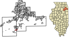
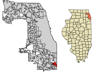
Lynwood is a village in Cook County, Illinois, United States and a suburb of Chicago. The population was 9,116 at the 2020 census.
Diamond is a village in Grundy and Will Counties, Illinois. The population was 2,640 at the 2020 census.
East Brooklyn is a village in Grundy County, Illinois, United States. The population was 80 at the 2020 census.
Gardner is a village in Grundy County, Illinois, United States. The population was 1,366 at the 2020 census.
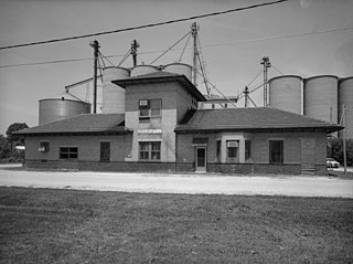
Mazon is a village in Mazon Township, Grundy County, Illinois, United States. The name derives from the Potawatomi word for "nettles" (mzan). The population was 979 at the 2020 census. Illinois' State Fossil, the unique and bizarre Tully Monster was first found in nearby Mazon Creek. Mazon was formerly served by the Santa Fe railway at the Mazon Depot. It was established in 1876.
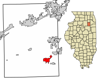
Minooka is a village in Grundy, Kendall, and Will counties, Illinois, United States. The population was 12,758 at the 2020 census, up from 10,924 at the 2010 census. The village is part of the Chicago metropolitan area.
South Wilmington is a village in Grundy County, Illinois, United States. The population was 710 at the 2020 census.
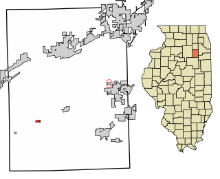
Verona is a village in Grundy County, Illinois. The population was 208 at the 2020 census.
Stout is a city in Grundy County, Iowa, United States. The population was 191 in the 2020 census, a decrease from the population of 217 in 2000. It is part of the Waterloo–Cedar Falls Metropolitan Statistical Area.
Alanson is a village in Emmet County in the U.S. state of Michigan. The population was 778 at the 2020 census.
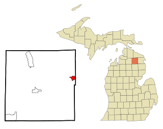
Hillman is a village in Alpena and Montmorency counties in the U.S. state of Michigan. The population was 605 as of the 2020 census. Nearly all of the village is located within Hillman Township, with only a small portion extending into Green Township.
Laurie is a city in southern Morgan and northern Camden counties, Missouri, United States. The population was 939 at the 2020 census.
Stewartstown is a town in Coös County, New Hampshire, United States. The population was 813 at the 2020 census, down from 1,004 at the 2010 census. It includes the village of West Stewartstown and is part of the Berlin, NH-VT Micropolitan Statistical Area.
Brimson is a village in western Grundy County, Missouri, United States. The population was 50 at the 2020 census.
Galt is a city in eastern Grundy County, Missouri, United States. The population was 168 at the 2020 census.
Brinkhaven, once known as Mount Holly and Gann, is a village in Knox County, Ohio, United States. The population was 114 at the 2020 census.
Bloomdale is a village in Wood County, Ohio, United States. The population was 665 at the 2020 census.
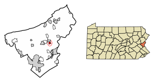
Tatamy is a borough in Northampton County, Pennsylvania. The borough's population was 1,203 as of the 2020 census. Tatamy is part of the Lehigh Valley metropolitan area, which had a population of 861,899 and was the 68th most populous metropolitan area in the U.S. as of the 2020 census.
Braceville Township is one of seventeen townships in Grundy County, Illinois, USA. As of the 2010 census, its population was 6,463 and it contained 2,617 housing units.
Greenfield Township is one of seventeen townships in Grundy County, Illinois, USA. As of the 2020 census, its population was 991 and it contained 449 housing units.
{{cite web}}
: Missing or empty |title=
(help)