
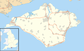
The Isle of Wight is a county and the largest and second-most populous island in England. It is in the English Channel, between two and five miles off the coast of Hampshire, separated by the Solent. The island has resorts that have been holiday destinations since Victorian times, and is known for its mild climate, coastal scenery, and verdant landscape of fields, downland and chines. The island is designated a UNESCO Biosphere Reserve.

Sandown is a seaside resort and civil parish on the south-east coast of the Isle of Wight, United Kingdom with the resort of Shanklin to the south and the settlement of Lake in between. Together with Shanklin, Sandown forms a built-up area of 21,374 inhabitants.

The Island Line is a railway line on the Isle of Wight that links Ryde Pier Head with Shanklin on the Island's east coast. The line was electrified in 1967. Trains connect with passenger ferries to Portsmouth Harbour at Ryde Pier Head, and these ferries in turn connect with the rest of the National Rail network via the Portsmouth Direct Line. The line also connects to the Isle of Wight Steam Railway, a steam-operated heritage railway at Smallbrook Junction. For much of its length the line runs alongside the A3055, criss-crossing this road by means of the Ryde Tunnel and bridges at Rowborough, Morton Common, Lake Hill and Littlestairs.
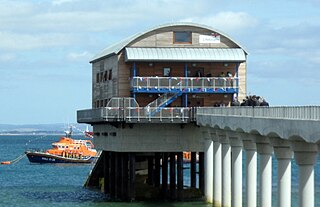
Bembridge is a village and civil parish located on the easternmost point of the Isle of Wight. It had a population of 3,848 according to the 2001 census of the United Kingdom, leading to the implausible claim by some residents that Bembridge is the largest village in England. Bembridge is home to many of the Island's wealthiest residents. The population had reduced to 3,688 at the 2011 Census.

The ancient 'Kynges Towne' of Brading is the main town of the civil parish of the same name. The ecclesiastical parish of Brading used to cover about a tenth of the Isle of Wight. The civil parish now includes the town itself and Adgestone, Morton, Nunwell and other outlying areas between Ryde, St Helens, Bembridge, Sandown and Arreton. Alverstone was transferred to the Newchurch parish some thirty years ago.

The Purbeck Hills, also called the Purbeck Ridge or simply the Purbecks, are a ridge of chalk downs in Dorset, England. It is formed by the structure known as the Purbeck Monocline. The ridge extends from Lulworth Cove in the west to Old Harry Rocks in the east, where it meets the sea. The hills are part of a system of chalk downlands in southern England formed from the Chalk Group which also includes Salisbury Plain and the South Downs. For most of their length the chalk of the Purbeck Hills is protected from coastal erosion by a band of resistant Portland limestone. Where this band ends, at Durlston Head, the clay and chalk behind has been eroded, creating Poole Bay and the Solent. The ridge of steeply dipping chalk that forms the Purbeck Hills continues further east on the Isle of Wight.

The Isle of Wight is rich in historical and archaeological sites, from prehistoric fossil beds with dinosaur remains, to dwellings and artefacts dating back to the Bronze Age, Iron Age, and Roman periods.

The Chalk Formation of Southern England is a system of chalk downland in the south of England. The formation is perhaps best known for Salisbury Plain, the location of Stonehenge, the Isle of Wight, and the twin ridgeways of the North Downs and South Downs.

Hampshire and Isle of Wight Wildlife Trust is a Wildlife Trust with 27,000 members across the counties of Hampshire and the Isle of Wight, England.

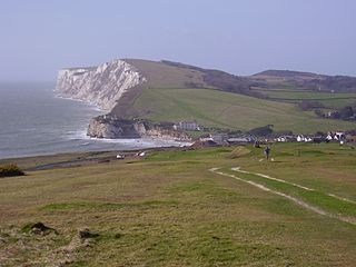
Sandown Bay is a broad open bay which stretches for much of the length of the Isle of Wight's southeastern coast. It extends 8 1⁄2 miles (13.7 km) from Culver Down, near Yaverland in the northeast of the Island, to just south of Shanklin, near the village of Luccombe in the southwest. At Luccombe, the bay is separated from The Undercliff by a large headland from which Upper Ventnor sits atop. The towns of Shanklin, Lake and Sandown are on the bay's coast, while Luccombe and Upper Ventnor feature panoramic views across both Sandown Bay to the East and the Undercliff to the southwest. Due to the bay being relatively sheltered from offshore winds it is often used as temporary anchorage point for boats, including large cargo ships, before continuing east towards Continental Europe, or north towards The Solent.

Noar Hill is a 63-hectare (160-acre) biological Site of Special Scientific Interest south of Selborne in Hampshire. It is a Nature Conservation Review site, Grade 2, and part of East Hampshire Hangers Special Area of Conservation. An area of 20 hectares is a nature reserve managed by the Hampshire and Isle of Wight Wildlife Trust.

Arreton Down is a 29.77 hectare biological Site of Special Scientific Interest on the Isle of Wight, originally notified in 1979 for its geological interest and then renotified in 1987, but for its biological interest only. It is public access land and popular with early morning dog walkers, who park near the chalk pit entrance. The land is marked by extensive ancient field features as yet unexcavated.
Yaverland is a village on the Isle of Wight, just north of Sandown on Sandown Bay. It has about 200 houses. About 1⁄3 of a mile away from the village is the Yaverland Manor and Church. Holotype fossils have been discovered here of Yaverlandia and a pterosaur, Caulkicephalus. The White Air extreme sports festival was held annually at Yaverland pay and display car park between 1997 and 2008, but moved to Brighton for 2009.
Tennyson Down is a hill at the west end of the Isle of Wight just south of Totland. Tennyson Down is a grassy, whale-backed ridge of chalk which rises to 482 ft/147m above sea level. Tennyson Down is named after the poet Lord Tennyson who lived at nearby Farringford House for nearly 40 years. The poet used to walk on the down almost every day, saying that the air was worth 'sixpence a pint'.
Garston's Down is an area of downland on the Isle of Wight, rising to an altitude of 151 m (495 ft). It is located in the centre of the island, south of Carisbrooke and west of Gatcombe, and is one of the best remaining inland examples of unimproved chalk downland. An area of 20.3 hectares was notified as a Site of Special Scientific Interest (SSSI) in 1971 for its biological features. The down is situated in a remote area and provides extensive views over the surrounding countryside and distant coast.

Headon Warren and West High Down is a 276.3 hectare Site of Special Scientific Interest (SSSI) located at the westernmost end of the Isle of Wight. The SSSI encompasses Headon Warren, a heather clad down to the north, the chalk downs of West High Down and Tennyson Down to the south, and the Needles, The Needles Batteries and Alum Bay to the west.
