Bradley, Derbyshire

Last updated

Bradley
Bradley Church in Derbyshire-by-Martyn-Glover.jpg
Church of All Saints, Bradley.
Derbyshire UK parish map highlighting Bradley.svg
Bradley parish highlighted within Derbyshire
Population313 (2011)
OS grid reference SK225457
District
Shire county
Region
Country England
Sovereign state United Kingdom
Post town ASHBOURNE
Postcode district DE6
Police Derbyshire
Fire Derbyshire
Ambulance East Midlands
List of places
UK
England
Derbyshire

Bradley is a village and civil parish in Derbyshire just east of Ashbourne. The population of the civil parish taken at the 2011 Census was 313. [1] Other neighbouring parishes include Hulland and Yeldersley.

Contents

History

Bradley was mentioned in the Domesday book of 1086 as belonging to Henry de Ferrers, [2] having previously been in the possession of "Aelfric of Bradbourne" and "Leofwin". [3] [4] The village is assessed as being worth twenty shillings (a fall, having been valued as worth £2 in 1066), and having a taxable value of 1 geld unit. [3] [4] The village is recorded as having 17 households, 6 of which were smallholdings. [3]

In 1891 Kelly described the village as "an agricultural parish and picturesque but scattered village" of 2,374 acres. [5] The soil is described as "chiefly gravel and clay", with the main crops grown being hay, wheat, barley, oats and turnips. [5] The population is recorded as 227 and the rateable value of the village given as £2,945. [5]

Village landmarks

All Saints' Church

The village's parish church is dedicated to All Saints. [6] Primarily constructed in the late 14th century, but incorporating some earlier work, it has an unusual layout with an aisleless nave and chancel, and no tower. [6] [7] In 1891 the church was described as "an edifice in the Decorated style of the early 14th century, consists of a small chancel and nave under a single roof, south porch and a wooden turret at the west end containing 3 bells, two of which date from 1722, the tenor being undated". [5]
The 18th century wooden bell-turret has been removed and one of the bells is attached to the rear wall. The church was substantially renovated in the 19th century. [7] The church contains several graves and monuments belonging to members of the Kniveton, Byrom and Meynell families, who had formerly resided at Bradley Hall opposite the church. [5] [6]

All Saints Church with Bradley Hall behind (red brick building) Bradley Church and Hall from Ladypond - geograph.org.uk - 306162.jpg
All Saints Church with Bradley Hall behind (red brick building)

Bradley Hall

The original Bradley Hall was sold by Sir Andrew Kniverton who was bankrupted by the English Civil War. [6] The Old Bradley Hall was demolished by Hugo Meynell in the late 18th century, who built the Hall we currently see. [6] What is known as "Bradley Hall" today was originally built to be part of a stable-block for a new Hall which was never built. [8] [9] The stable block was later converted to serve as the residence. [8] [9] Additions were made to the Hall in both the 19th and 20th centuries; it is currently protected as Grade II Listed. [8] The hall was recently listed up for sale with a guide price of £2,900,000. [10]

Hole-in-the-Wall

Hole-in-the-Wall is a pair of brick tenements dated 1750–51, with a central road arch, on the outskirts of the main village. It was formally the entrance gate to the park. [6] [11]

Primary school

The Church of England primary school was founded in 1873. [6]

Notable residents

The following lines are by Sir Aston Cockayne and begin a commendation of Bancroft's poem:

From your retir'd abode in Bradley town,
Welcome, my friend, abroad to fair renown.
Nova Atlantis and Eutopia you
Again expose unto the publique view [12]

See also

Related Research Articles

<span class="mw-page-title-main">Monyash</span> Human settlement in England

Monyash is a village and civil parish in the Peak District, Derbyshire, England, 5 miles (8.0 km) west of the market town Bakewell. It is centred on a village green 265 metres (869 ft) above sea level at the head of Lathkill Dale in the limestone area known as the White Peak. At the 2011 census, it had a population of 314. Tourism and farming are the predominant activities of the village. The area was once an important meeting place, a watering point for drovers’ animals at the intersection of several trade routes, and industrial centre supporting the local lead mining industry.

<span class="mw-page-title-main">Tissington</span> Human settlement in England

Tissington is a village and former civil parish, now in the parish of Tissington and Lea Hall, in the Derbyshire Dales district of Derbyshire, England. In 2001 the parish had a population of 158. The population "Tissington and Lea Hall" at the 2011 census was 159. It is part of the estate of Tissington Hall, owned by the FitzHerbert family since 1465. It is a popular tourist attraction, particularly during its well dressing week. It also gives its name to the Tissington Trail, a 13-mile (21 km) walk and cycle path which passes nearby. The Limestone Way, another long-distance path and bridleway, passes through the village itself.

<span class="mw-page-title-main">Markeaton</span> Human settlement in England

Markeaton is a suburban village and former civil parish within Derby in the ceremonial county of Derbyshire, England. It is in the Mackworth Ward of Derby City Council.

<span class="mw-page-title-main">Atlow</span> Human settlement in England

Atlow is a village and civil parish in the Derbyshire Dales district of Derbyshire, England, about eight miles west of Belper. According to the 2001 census the parish had a population of 98. At the 2011 Census the population remained less than 100. Details are included in the civil parish of Hognaston.

<span class="mw-page-title-main">Bilsby</span> Village in East Lindsey district, Lincolnshire, England

Bilsby is a village and civil parish in the East Lindsey district of Lincolnshire, England. It lies on the main A1111 road between Alford and Sutton-on-Sea, 1 mile (1.6 km) east of Alford. Thurlby and Asserby are hamlets within Bilsby parish. The censuses showed a parish population of 538 in 2001 and 487 in 2011, with an estimate of 489 in 2019.

<span class="mw-page-title-main">Bradbourne</span> Human settlement in England

<span class="mw-page-title-main">Brailsford</span> Human settlement in England

<span class="mw-page-title-main">Alsop en le Dale</span> Human settlement in England

Alsop en le Dale is a village in Derbyshire, England about 5 miles (8.0 km) north of Ashbourne close to the Staffordshire border, and a mile from Dovedale, a popular tourist location within the Peak District national park. It is within the civil parish of Eaton and Alsop.

<span class="mw-page-title-main">Sturston, Derbyshire</span> Human settlement in England

Sturston is a small area of settlement in Derbyshire, England. It is located on the A517 road, 1-mile (1.6 km) east of Ashbourne. It is in the civil parish of Offcote and Underwood.

<span class="mw-page-title-main">Kniveton</span> Human settlement in England

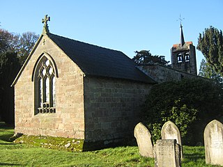
Kniveton is a village and civil parish in Derbyshire, England. It is in the Peak District, 3 miles (4.8 km) north east of Ashbourne, 6 miles (9.7 km) south west of Wirksworth and 150 miles (240 km) from London. It is close to the reservoir at Carsington Water.

<span class="mw-page-title-main">Edlaston</span> Human settlement in England

Edlaston is a village three miles south of Ashbourne in Derbyshire, just off the A515 road. It is in close proximity to the hamlet of Wyaston, and the civil parish is called Edlaston and Wyaston. It had a population of 220 at the 2011 Census.

<span class="mw-page-title-main">Parwich</span> Human settlement in England

Parwich is a village and parish in the Derbyshire Dales, 7 miles north of Ashbourne. In the 2011 census the population of the civil parish was 472.

<span class="mw-page-title-main">Holton le Moor</span> Small village and civil parish in the West Lindsey district of Lincolnshire, England

Holton le Moor is a small village and civil parish in the West Lindsey district of Lincolnshire, England.

<span class="mw-page-title-main">Seckington</span> Human settlement in England

Seckington is a village and civil parish in North Warwickshire, about 4 miles (6 km) northeast of Tamworth. The B4593 road between Tamworth and Appleby Magna runs through the parish, passing about 100 yards (91 m) north of the village. Seckington shares a parish council with Newton Regis and No Man's Heath. Forming part of the border with Staffordshire, it is the second most northerly settlement in Warwickshire, with only No Man's Heath situated further north, and is only 3.5 miles due south of the Derbyshire border.

<span class="mw-page-title-main">Gayton le Wold</span> Village and civil parish in the East Lindsey district of Lincolnshire, England

Gayton le Wold is a village and civil parish in the East Lindsey district of Lincolnshire, England. It lies 6 miles (10 km) west from Louth, 3 miles (5 km) north from Donington on Bain, and to the south of the A157. The parish includes Biscathorpe 1 mile (1.6 km) to the south-west.

<span class="mw-page-title-main">Wildsworth</span> Village and civil parish in the West Lindsey district of Lincolnshire, England

Wildsworth is a village and civil parish in the West Lindsey district of Lincolnshire, England. It is situated on the eastern bank of the River Trent, and approximately 5 miles (8 km) north from Gainsborough. The population is included in the civil parish of East Ferry.

<span class="mw-page-title-main">St Andrew's Church, Billingborough</span> Church in United Kingdom

St Andrew's Church is a Grade I listed Anglican parish church dedicated to Andrew the Apostle, in Billingborough, Lincolnshire, England. The church is 7 miles (11 km) south-east from Sleaford, and at the western edge of the Lincolnshire Fenlands.

<span class="mw-page-title-main">Clifton and Compton</span> Civil parish in Derbyshire, England

Clifton and Compton is a civil parish within the Derbyshire Dales district, in the county of Derbyshire, England. The parish, despite the name, only includes the villages of Clifton and Hangingbridge. In 2011 the parish had a population of 500. It is 124 miles (200 km) north west of London, 13 miles (21 km) north west of the county city of Derby, and 1+13 miles south west of the market town of Ashbourne. Clifton and Compton touches the parishes of Ashbourne, Edlaston and Wyaston, Mayfield, Offcote and Underwood, Osmaston, Okeover and Snelston. There are eight listed buildings in Clifton and Compton.

<span class="mw-page-title-main">Edlaston and Wyaston</span> Civil parish in Derbyshire, England

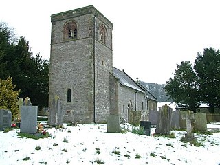
Edlaston and Wyaston is a civil parish within the Derbyshire Dales district, in the county of Derbyshire, England. The parish includes the villages of Edlaston and Wyaston. In 2011 the parish had a population of 220. It is 120 miles (190 km) north west of London, 11 miles (18 km) north west of the county city of Derby, and 2+12 miles (4 km) south of the market town of Ashbourne. Edlaston and Wyaston touches the parishes of Clifton and Compton, Osmaston, Rodsley, Shirley, Snelston and Yeaveley. There are seven listed buildings in Edlaston and Wyaston.

<span class="mw-page-title-main">Eaton and Alsop</span> Civil parish in Derbyshire Dales, England

Eaton and Alsop is a civil parish within the Derbyshire Dales district, in the county of Derbyshire, England. Largely rural, Along with the adjacent Newton Grange parish, in 2011 Eaton and Alsop had a population of 155. It is 130 miles (210 km) north west of London, 17 miles (27 km) north west of the county city of Derby, and 6 miles (9.7 km) north of the market town of Ashbourne. Eaton and Alsop is wholly within the Peak District national park, and touches the parishes of Alstonefield, Hartington Nether Quarter, Newton Grange and Parwich. There are five listed buildings in Eaton and Alsop.

References

  1. "Civil Parish population 2011". Neighbourhood Statistics. Office for National Statistics. Retrieved 20 March 2016.
  2. Henry was given a large number of manors in Derbyshire including Shirley, Aston-on-Trent and Pilsbury.
  3. 1 2 3 "Bradley". Domesday Map. Archived from the original on 28 June 2012. Retrieved 5 May 2013.
  4. 1 2 Domesday Book: A Complete Translation. London: Penguin, 2003. ISBN   0-14-143994-7 p.747
  5. 1 2 3 4 5 Kelly (1891). Kelly's Directory of the Counties of Derby, Notts, Leicester and Rutland. pp. 54–5.
  6. 1 2 3 4 5 6 7 "Bradley near Ashbourne". Derbyshire UK. Retrieved 5 May 2013.
  7. 1 2 "All Saints Church, Bradley". British Listed Buildings. Retrieved 5 May 2013.
  8. 1 2 3 "Bradley Hall". British Listed Buildings. Retrieved 5 May 2013.
  9. 1 2 "Bradley Hall Sales Brochure" . Retrieved 5 May 2013.[ permanent dead link ]
  10. "Bradley Hall Sales Catalogue". Archived from the original on 19 June 2013. Retrieved 5 May 2013.
  11. Pevsner, Nikolaus. 1986. The Buildings of England: Derbyshire. pp 104–105. Harmondsworth, Middx. Penguin.
  12. The Heroical Lover [ permanent dead link ] accessed 25 November 2007
  13. "Major Ernest William Clowes". ThePeerage.com. Darryl Lundy. Retrieved 22 August 2019.
  14. Duckett, Richard. "The men of SOE Burma". SOE in Burma. Retrieved 22 August 2019.

53°00′32″N1°39′58″W / 53.009°N 1.666°W / 53.009; -1.666