Perkins School for the Blind, in Watertown, Massachusetts, was founded in 1829 and is the oldest school for the blind in the United States. It has also been known as the Perkins Institution for the Blind.

The East Coast Greenway is a 3,000-mile (4,800 km) pedestrian and bicycle route between Maine and Florida along the East Coast of the United States. The nonprofit East Coast Greenway Alliance was created in 1991 with the goal to use the entire route with off-road, shared-use paths; as of 2021, over 1,000 mi (1,600 km) of the route (35%) meets these criteria. In 2020, the Greenway received over 50 million visits.

The Minuteman Bikeway, also known as the Minuteman Commuter Bikeway, is a 10-mile (16-kilometre) paved multi-use rail trail located in the Greater Boston area of Massachusetts. It runs from Bedford to Alewife station, at the northern end of the Red Line in Cambridge, passing through the towns of Lexington and Arlington along the way. Also along the route are several notable regional sites, including Alewife Brook Reservation, the Cyrus Dallin Art Museum, Spy Pond, "Arlington’s Great Meadows", the Battle Green in Lexington, and Hanscom Air Force Base.

A greenway is usually a shared-use path along a strip of undeveloped land, in an urban or rural area, set aside for recreational use or environmental protection. Greenways are frequently created out of disused railways, canal towpaths, utility company rights of way, or derelict industrial land. Greenways can also be linear parks, and can serve as wildlife corridors. The path's surface may be paved and often serves multiple users: walkers, runners, bicyclists, skaters and hikers. A characteristic of greenways, as defined by the European Greenways Association, is "ease of passage": that is that they have "either low or zero gradient", so that they can be used by all "types of users, including mobility impaired people".

The Founders Bridge is one of the three highway bridges over the Connecticut River between Hartford, Connecticut and East Hartford, Connecticut. The steel stringer bridge carries the Route 2 freeway, and also crosses over Interstate 91. As of 2013 the bridge had an average daily traffic of 29,200.

The Charles River Reservation is a 17-mile-long (27 km) urban preserve and public recreation area located along the banks of the Charles River in Boston, Cambridge, Watertown, and Newton, Massachusetts. The reservation is managed by the Massachusetts Department of Conservation and Recreation.

North Shore Riverfront Park is a small municipal park along the north banks of the Allegheny and Ohio Rivers across from Downtown Pittsburgh, Pennsylvania, United States.

The Detroit International Riverfront is a tourist attraction and landmark of Detroit, Michigan, extending from the Ambassador Bridge in the west to Belle Isle in the east, for a total of 5.5 miles along the Detroit River. The International Riverfront encompasses a cruise ship passenger terminal and dock, a marina, a multitude of parks, restaurants, retail shops, skyscrapers, and high rise residential areas along with Huntington Place. The Marriott at the Renaissance Center and the Robert's Riverwalk Hotel are also situated along the International Riverfront. Private companies and foundations together with the city, state, and federal government have contributed several hundred million dollars toward the riverfront development. Key public spaces in the International Riverfront, such as the RiverWalk, Dequindre Cut Greenway and Trail, William G. Milliken State Park and Harbor, and a cruise ship passenger terminal and dock at Hart Plaza complement the architecture of the area. The area provides a venue for a variety of annual events and festivals including the Detroit Electronic Music Festival, Detroit Free Press International Marathon, the Detroit International Jazz Festival, Motor City Pride, the North American International Auto Show, River Days and Detroit China Festival. In February 2021, the Detroit International Riverfront was voted best riverwalk in the United States by USA Today readers. It was selected a second time as the best riverwalk in the U.S. in 2022.

The Charles River Bike Path is a mixed-use path in the Boston, Massachusetts area. A portion of the trail is named after the cardiologist Paul Dudley White, a prominent advocate of preventive medicine. His research led him to proclaim frequently "I'd like to put everybody on bicycles." In 1955 White served as president Eisenhower's cardiologist and prescribed his famous patient bicycle therapy after his 1955 heart attack.
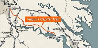
The Virginia Capital Trail (VCT) (informally, the Cap Trail, or simply the Cap) is a dedicated, paved bicycle and pedestrian trail crossing four counties and 51.7 miles (83.2 km) between Jamestown and Richmond, Virginia — that is, between the Colony of Virginia's first capital and Virginia's current capital.
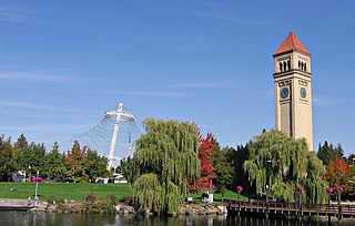
Riverfront Park, branded as Riverfront Spokane, is a public urban park in downtown Spokane, Washington that is owned and operated by the Spokane Parks & Recreation Department. The 100-acre (40 ha) park is situated along the Spokane River and encompasses the Upper Spokane Falls, which is the second largest urban waterfall in the United States.

The Watertown Branch Railroad was a branch loop of the Fitchburg Railroad that was meant to serve the town of Watertown and the City of Waltham, Middlesex County, Massachusetts, as an independent short line railroad; it also serviced the Watertown Arsenal. The line has been formally abandoned and portions have been converted into a rail trail, the Watertown-Cambridge Greenway. A section from School Street to Arlington Street in Watertown was completed first. A small portion in Waltham has been converted into a park called Chemistry Station Park after the railroad station once located there. Construction of an extension to Fresh Pond Reservation in Cambridge began in the summer of 2018 and was completed in June 2022.

The Dequindre Cut is a below-grade pathway, formerly a Grand Trunk Western Railroad line, located on the east side of Detroit, Michigan, just west of St. Aubin Street. Much of the Cut has been converted to a greenway; the colorful graffiti along the pathway has been left in place.

The Upper Charles River Reservation is a Massachusetts state park encompassing portions of the banks of the Charles River between the Watertown Dam in Watertown and Riverdale Park in Dedham and the West Roxbury neighborhood of Boston. The park is managed by the Massachusetts Department of Conservation and Recreation. It includes land in the communities of Watertown, Waltham, Newton, Weston, Wellesley, Needham, Dedham, and Boston. Some of the Charles River Reservation Parkways also fall within the park boundaries. The Charles River Bike Path follows the river through much of the reservation.

Ross's Landing in Chattanooga, Tennessee, is the last site of the Cherokee's 61-year occupation of Chattanooga and is considered to be the embarkation point of the Cherokee removal on the Trail of Tears. Ross's Landing Riverfront Park memorializes the location, which is listed on the National Register of Historic Places.
The Riverfront Trail is a multiuse trail in Greater Moncton, along the shores of the Petitcodiac River. The trail comprises the Moncton section of the Trans Canada Trail, passing through the city's Riverfront Park, and extends to the neighbouring communities of Riverview and Dieppe. Points of interest include Bore View Park, Settlers Green, a skateboard park, the Hal Betts Commemorative Sportsplex and the Treitz Haus.

Louise McKinney Riverfront Park or Louise McKinney Park is a municipal park in Edmonton, Alberta, Canada, that is part of the North Saskatchewan River valley parks system, and serves as the gateway park, with paved paths leading from it to everywhere in the parks system. The Cloverdale Pedestrian Bridge crossed the North Saskatchewan River connecting Louise McKinney Park to the Henrietta Muir Edwards Park and the Edmonton Queen attraction. The park is the closest to the downtown Edmonton area. The park also serves as a link in the trans-Canadian trail system.
312 RiverRun is a Chicago public hiking area along the Chicago River. The development is a further move toward Chicago's goal of having a continuous pedestrian path along the entire riverfront.

Newark Riverfront Park is a park and promenade being developed in phases along the Passaic River in Newark, New Jersey, United States. It is part of the Essex County Park System. The park, expected to be 3 miles (4.8 km) long and encompass 30.5 acres (12.3 ha), is being created from brownfield and greyfield sites along the river, which itself is a Superfund site due to decades of pollution. It will follow the river between the Ironbound section along Raymond Boulevard and Downtown Newark along McCarter Highway. Announced in 1999, a groundbreaking took place in 2008, and the first phase of the park opened in 2012. It was the first time residents of the largest city in New Jersey have ever had public access to the river. Other segments of the park have subsequently opened, while others are being developed. The East Coast Greenway uses paths and roads along the park.

The Scioto Mile Promenade, also known simply as the Promenade, is a public park and promenade in downtown Columbus, Ohio. The park is part of the Scioto Mile network of parks and trails around the city's downtown area, and has a riverwalk stretching along the east bank of the Scioto River, from Battelle Riverfront Park to Bicentennial Park.
