
A wharf, quay, staith, or staithe is a structure on the shore of a harbour or on the bank of a river or canal where ships may dock to load and unload cargo or passengers. Such a structure includes one or more berths, and may also include piers, warehouses, or other facilities necessary for handling the ships. Wharves are often considered to be a series of docks at which boats are stationed.

Horning is an ancient village and parish in the English county of Norfolk. It covers an area of 11 km2 and had a population of 1,033 in the 2001 census. Horning parish lies on the northern bank of the River Bure south of the River Thurne and is located in The Broads National Park. For the purposes of local government, it falls within the district of North Norfolk, although areas alongside the rivers and broads fall into the executive area of the Broads Authority.

Blakeney is a coastal village and civil parish in the English county of Norfolk. Blakeney lies within the Norfolk Coast AONB and the North Norfolk Heritage Coast. The North Norfolk Coastal Path travels along its quayside. The village is 21.1 mi (34 km) north west of Norwich, 4.6 mi (7.4 km) NNW of the larger settlement of Holt, 11.5 mi (18.5 km) west of Cromer and 112 mi (180 km) NNE of London.
The Norfolk Coast Path is a long-distance footpath in Norfolk, running 83 miles (133.5 km) from Hunstanton to Hopton-on-Sea. It was opened in 1986 and covers the North Norfolk Coast AONB.

Burnham-on-Crouch is a town and civil parish in the Maldon District of Essex in the East of England. It lies on the north bank of the River Crouch. It is one of Britain's leading places for yachting.
Holkham is a small village and civil parish in north Norfolk, England, which includes a stately home and estate, Holkham Hall, and a beach, Holkham Gap, at the centre of Holkham National Nature Reserve.
The Norfolk Burnhams are a group of adjacent villages on the north coast of Norfolk, England. The villages are located near a large natural bay named Brancaster Bay and the Scolt Head Island National Nature Reserve.

Brancaster is a village and civil parish on the north coast of the English county of Norfolk. The civil parish of Brancaster comprises Brancaster itself, together with Brancaster Staithe and Burnham Deepdale. The three villages form a more or less continuous settlement along the A149 at the edge of the Brancaster Manor marshland and the Scolt Head Island National Nature Reserve. The villages are located about 3 miles (4.8 km) west of Burnham Market, 22 miles (35 km) north of the town of King's Lynn and 31 miles (50 km) north-west of the city of Norwich. The civil parish has an area of 8.27 square miles (21.4 km2) and in the 2011 census had a population of 797 in 406 households. For the purposes of local government, the parish falls within the district of King's Lynn and West Norfolk. Janet Lake, the clerk to Brancaster Parish Council, has recently reached 50 years of service in the post.

Staithes is a seaside village in the borough of Scarborough in North Yorkshire, England. Easington and Roxby Becks, two brooks that run into Staithes Beck, form the border between the Borough of Scarborough and Redcar and Cleveland. The area located on the Redcar and Cleveland side is called Cowbar. Formerly one of the many fishing centres in England, Staithes is now largely a tourist destination within the North York Moors National Park.

Titchwell is a village and civil parish in Norfolk, England. It is situated on the north Norfolk coast some 2 km (1.2 mi) west of the village of Brancaster, 9 km (5.6 mi) north-east of the seaside resort of Hunstanton, 30 km (19 mi) north of the town of King's Lynn and 70 km (43 mi) north-west of the city of Norwich.

Burnham Overy is a civil parish on the north coast of Norfolk, England. In modern times a distinction is often made between the two settlements of Burnham Overy Town, the original village adjacent to the medieval parish church and now reduced to a handful of houses, and Burnham Overy Staithe, a rather larger hamlet about 1-mile (1.6 km) away and next to the creek-side harbour.
Burnham Deepdale is a village and former civil parish, now in the parish of Brancaster, in the King's Lynn and West Norfolk district, on the north coast of the county of Norfolk, England. Burnham Deepdale, Brancaster and Brancaster Staithe form a more or less continuous settlement along the A149, at the edge of the Brancaster Manor marshland and the Scolt Head Island National Nature Reserve. In 1931 the parish had a population of 81.

Richard Woodget was an English sea captain, best known as the master of the famous sailing clipper Cutty Sark during her most successful period of service in the wool trade between Australia and the United Kingdom.

Scolt Head Island is an offshore barrier island between Brancaster and Wells-next-the-Sea in north Norfolk. It is in the parish of Burnham Norton and is accessed by a seasonal ferry from the village of Overy Staithe. The shingle and sand island appears to have originated from a former spit extending from the coast, and longshore drift means that it is slowly moving to the west and inshore.

The A149 is commonly known as "The Coast Road" to local residents and tourists, as this road runs along the North Norfolk coast from King's Lynn to Cromer, via coastal villages.

Runswick Bay is a bay in the Scarborough Borough of North Yorkshire, England. It is also the name of a village located on the western edge of the bay. It is 5 miles (8 km) north of Whitby, and close to the villages of Ellerby and Hinderwell. It is a popular tourist attraction due to its picturesque cliffside village, stunning coastal walks, fossil hunting and Runswick Sands, a white sand beach. It is on the Cleveland Way national trail. Runswick Bay was chosen as Beach of the Year 2020 by The Sunday Times.

Burnham Overy Staithe Windmill is a Grade II* listed building tower mill at Burnham Overy Staithe, Norfolk, England which has been converted to holiday accommodation.
Burnham Market was a railway station which served the village of Burnham Market in Norfolk, England. Opened by the West Norfolk Junction railway in 1866, it closed with the line in 1952.

The North Norfolk Coast Site of Special Scientific Interest (SSSI) is an area of European importance for wildlife in Norfolk, England. It comprises 7,700 ha (19,027 acres) of the county's north coast from just west of Holme-next-the-Sea to Kelling, and is additionally protected through Natura 2000, Special Protection Area (SPA) listings; it is also part of the Norfolk Coast Area of Outstanding Natural Beauty (AONB). The North Norfolk Coast is also designated as a wetland of international importance on the Ramsar list and most of it is a Biosphere Reserve.

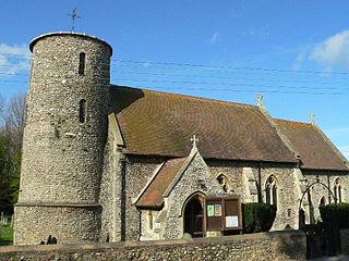
St Mary's Church is a round-tower church in Burnham Deepdale, Norfolk, England. Its round tower and some other parts of the building date from the 11th century. The church underwent additions and rebuilding in the medieval period. It fell into disrepair by the early 18th century, and much of the current building's appearance dates from an 1870 renovation by Frederick Preedy. The church is famed for its many 14th- and 15th-century medieval stained glass windows, and for its Norman font depicting the Labours of the Months.

