Brannenburg

Last updated
Brannenburg
Brannenburg Schloss-1.jpg
Brannenburg Castle in 2007
Wappen von Brannenburg.svg
Location of Brannenburg within Rosenheim district
Brannenburg in RO.svgRotter Forst-SüdRotter Forst-NordEdlingRohrdorf
Germany adm location map.svg
Red pog.svg
Brannenburg
Bavaria location map.svg
Red pog.svg
Brannenburg
Coordinates: 47°44′N12°6′E / 47.733°N 12.100°E / 47.733; 12.100
Country Germany
State Bavaria
Admin. region Oberbayern
District Rosenheim
Subdivisions3 Ortsteile
Government
   Mayor (202026) Matthias Jokisch [1] (CSU)
Area
  Total33.66 km2 (13.00 sq mi)
Elevation
509 m (1,670 ft)
Population
 (2022-12-31) [2]
  Total6,850
  Density200/km2 (530/sq mi)
Time zone UTC+01:00 (CET)
  Summer (DST) UTC+02:00 (CEST)
Postal codes
83098
Dialling codes 08034
Vehicle registration RO
Website www.gemeinde-brannenburg.de

Brannenburg is a municipality in the district of Rosenheim in Bavaria in Germany. There is a railway station located in Brannenburg. [3]

Related Research Articles

<span class="mw-page-title-main">Vilshofen an der Donau</span> Town in Bavaria, Germany

Vilshofen an der Donau is a town in the German district of Passau.

<span class="mw-page-title-main">Oberaudorf</span> Municipality in Bavaria, Germany

Oberaudorf is a municipality in the district of Rosenheim in Bavaria, Germany. It lies on the river Inn.

<span class="mw-page-title-main">Schwandorf</span> Town in Bavaria, Germany

Schwandorf is a town on the river Naab in the Upper Palatinate, Bavaria, Germany, which is the seat of the Schwandorf district.

<span class="mw-page-title-main">Baar, Bavaria</span> Municipality in Bavaria, Germany

Baar is a municipality in Aichach-Friedberg district, in Bavaria, southern Germany.

<span class="mw-page-title-main">Bruckmühl</span> Municipality in Bavaria, Germany

Bruckmühl is a market town in the district of Rosenheim, in Bavaria, Germany. It is situated on the river Mangfall, 16 km west of Rosenheim.

<span class="mw-page-title-main">Gräfelfing</span> Municipality in Bavaria, Germany

Gräfelfing is a municipality in the district of Munich, in Bavaria, Germany. It is located 1 km west of Munich.

<span class="mw-page-title-main">Merkendorf, Bavaria</span> Town in Bavaria, Germany

Merkendorf is a town and municipality in the district of Ansbach, in Bavaria, Germany. It is situated 14 km southeast of Ansbach.

<span class="mw-page-title-main">Thannhausen</span> Town in Bavaria, Germany

Thannhausen is a town in the district of Günzburg, in Bavaria, Germany. It is situated on the river Mindel, 24 kilometres (15 mi) southeast of Günzburg, and 33 kilometres (21 mi) west of Augsburg.

<span class="mw-page-title-main">Eggolsheim</span> Municipality in Bavaria, Germany

Eggolsheim is a municipality in the district of Forchheim in Bavaria in Germany.

<span class="mw-page-title-main">Wörnitz</span> Municipality in Bavaria, Germany

Wörnitz is a municipality in the district of Ansbach, in Bavaria, Germany. It is situated on the river Wörnitz, west of Ansbach.

<span class="mw-page-title-main">Dürrwangen</span> Municipality in Bavaria, Germany

Dürrwangen is a municipality in the district of Ansbach in Bavaria in Germany.

<span class="mw-page-title-main">Ohrenbach</span> Municipality in Bavaria, Germany

Ohrenbach is a municipality in the district of Ansbach in Bavaria in Germany.

<span class="mw-page-title-main">Petersaurach</span> Municipality in Bavaria, Germany

Petersaurach is a municipality in the district of Ansbach in Bavaria in Germany.

<span class="mw-page-title-main">Heroldsbach</span> Municipality in Bavaria, Germany

Heroldsbach is a municipality in the district of Forchheim in Bavaria in Germany.

<span class="mw-page-title-main">Leuchtenberg</span> Municipality in Bavaria, Germany

Leuchtenberg is a municipality in the district of Neustadt an der Waldnaab in Bavaria, Germany, essentially a suburb of nearby Weiden in der Oberpfalz, and a larger historical region in the Holy Roman Empire governed by the Landgraves of Leuchtenberg.

<span class="mw-page-title-main">Oberstaufen</span> Municipality in Bavaria, Germany

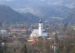
Oberstaufen is a municipality in the district of Oberallgäu in Bavarian Swabia, Germany, situated on the B 308 road from Lindau to Immenstadt.

<span class="mw-page-title-main">Halblech</span> Municipality in Bavaria, Germany

Halblech is a municipality in the district of Ostallgäu in Bavaria in Germany.

<span class="mw-page-title-main">Roßhaupten</span> Municipality in Bavaria, Germany

Roßhaupten is a municipality in the district of Ostallgäu in Bavaria in Germany.

<span class="mw-page-title-main">Hohenroth</span> Municipality in Bavaria, Germany

Hohenroth is a municipality in the district of Rhön-Grabfeld in Bavaria in Germany.

<span class="mw-page-title-main">Kist, Bavaria</span> Municipality in Bavaria, Germany

Kist is a municipality in the district of Würzburg in Bavaria in Germany.

References

  1. Liste der ersten Bürgermeister/Oberbürgermeister in kreisangehörigen Gemeinden, Bayerisches Landesamt für Statistik, 15 July 2021.
  2. Genesis Online-Datenbank des Bayerischen Landesamtes für Statistik Tabelle 12411-003r Fortschreibung des Bevölkerungsstandes: Gemeinden, Stichtag (Einwohnerzahlen auf Grundlage des Zensus 2011) (Hilfe dazu).
  3. "Bahnhof Brannenburg - Brannenburg, Bayern, Germany - BY". Yelp. Retrieved 2021-05-14.