Bret Harte, California

Last updated

Bret Harte
USA California location map.svg
Red pog.svg
Bret Harte
Position in California.
Usa edcp location map.svg
Red pog.svg
Bret Harte
Bret Harte (the United States)
Coordinates: 37°36′11″N121°0′21″W / 37.60306°N 121.00583°W / 37.60306; -121.00583
Country Flag of the United States.svg  United States
State Flag of California.svg  California
County Stanislaus
Area
[1]
  Total0.55 sq mi (1.43 km2)
  Land0.55 sq mi (1.43 km2)
  Water0.00 sq mi (0.00 km2)  0%
Population
 (2020)
  Total5,135
  Density9,336.36/sq mi (3,603.36/km2)
Time zone UTC-8 (Pacific (PST))
  Summer (DST) UTC-7 (PDT)
ZIP code
95358
Area code 209
FIPS code 06-08172
GNIS feature ID 2407902

Bret Harte is a census-designated place (CDP) in Stanislaus County, California, United States. The population was 5,152 at the 2010 census, down from 5,161 at the 2000 census. It is part of the Modesto Metropolitan Statistical Area. It is named for the American poet and short story writer, Bret Harte, best known for his writings about the California Gold Rush.

Contents

Geography

Bret Harte is located at 37°36′11″N121°0′21″W / 37.60306°N 121.00583°W / 37.60306; -121.00583 (37.603182, -121.005844). [2]

According to the United States Census Bureau, the CDP has a total area of 0.5 square miles (1.3 km2), all of it land.

Demographics

Historical population
CensusPop.Note
2020 5,135
U.S. Decennial Census [3]

2010

At the 2010 census Bret Harte had a population of 5,152. The population density was 9,388.7 inhabitants per square mile (3,625.0/km2). The racial makeup of Bret Harte was 2,441 (47.4%) White, 52 (1.0%) African American, 50 (1.0%) Native American, 40 (0.8%) Asian, 45 (0.9%) Pacific Islander, 2,327 (45.2%) from other races, and 197 (3.8%) from two or more races. Hispanic or Latino of any race were 4,272 persons (82.9%). [4]

The whole population lived in households, no one lived in non-institutionalized group quarters and no one was institutionalized.

There were 1,185 households, 761 (64.2%) had children under the age of 18 living in them, 649 (54.8%) were opposite-sex married couples living together, 230 (19.4%) had a female householder with no husband present, 141 (11.9%) had a male householder with no wife present. There were 130 (11.0%) unmarried opposite-sex partnerships, and 6 (0.5%) same-sex married couples or partnerships. 94 households (7.9%) were one person and 36 (3.0%) had someone living alone who was 65 or older. The average household size was 4.35. There were 1,020 families (86.1% of households); the average family size was 4.41.

The age distribution was 1,851 people (35.9%) under the age of 18, 688 people (13.4%) aged 18 to 24, 1,457 people (28.3%) aged 25 to 44, 870 people (16.9%) aged 45 to 64, and 286 people (5.6%) who were 65 or older. The median age was 25.5 years. For every 100 females, there were 109.4 males. For every 100 females age 18 and over, there were 106.8 males.

There were 1,293 housing units at an average density of 2,356.3 per square mile, of the occupied units 555 (46.8%) were owner-occupied and 630 (53.2%) were rented. The homeowner vacancy rate was 1.9%; the rental vacancy rate was 6.9%. 2,389 people (46.4% of the population) lived in owner-occupied housing units and 2,763 people (53.6%) lived in rental housing units.

2000

At the 2000 census there were 5,161 people, 1,174 households, and 1,013 families in the CDP. The population density was 9,183.3 inhabitants per square mile (3,545.7/km2). There were 1,250 housing units at an average density of 2,224.2 per square mile (858.8/km2). The racial makeup of the CDP was 40.34% White, 1.14% African American, 1.92% Native American, 0.62% Asian, 0.02% Pacific Islander, 50.71% from other races, and 5.25% from two or more races. Hispanic or Latino of any race were 76.07%. [5]

Of the 1,174 households 54.9% had children under the age of 18 living with them, 59.5% were married couples living together, 17.8% had a female householder with no husband present, and 13.7% were non-families. 9.7% of households were one person and 5.4% were one person aged 65 or older. The average household size was 4.40 and the average family size was 4.59.

The age distribution was 38.3% under the age of 18, 13.1% from 18 to 24, 28.3% from 25 to 44, 14.1% from 45 to 64, and 6.2% 65 or older. The median age was 24 years. For every 100 females, there were 104.0 males. For every 100 females age 18 and over, there were 112.3 males.

The median household income was $26,568 and the median family income was $27,155. Males had a median income of $27,591 versus $17,885 for females. The per capita income for the CDP was $7,481. About 30.0% of families and 38.1% of the population were below the poverty line, including 43.7% of those under age 18 and 18.8% of those age 65 or over.

Government

In the California State Legislature, Bret Harte is in the 12th Senate District , represented by Republican Shannon Grove, and the 21st Assembly District , represented by Democrat Diane Papan. [6]

In the United States House of Representatives, Bret Harte is in California's 10th congressional district , represented by Democrat Mark DeSaulnier. [7]

See also

Related Research Articles

<span class="mw-page-title-main">West Point, California</span> Census-designated place in California, United States

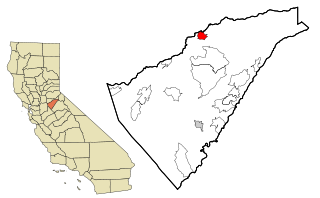
West Point is a census-designated place (CDP) in Calaveras County, California, in the United States. As of the 2010 United States Census, West Point's population was 674, down from 746 as of the 2000 census. The town is registered as California Historical Landmark #268. There is an annual West Point Lumberjack Days festival in the community.

<span class="mw-page-title-main">Diablo, California</span> Census-designated place in California, United States

Diablo is a census-designated place (CDP) in Contra Costa County, California, United States. The population was 1,158 at the 2010 census. It is located 2.5 miles (4.0 km) east-northeast of Danville.

<span class="mw-page-title-main">Mountain View, Contra Costa County, California</span> Census designated place in California, United States

Mountain View is a census designated place (CDP) in Contra Costa County, California, United States. The population was 2,372 at the 2010 census.

<span class="mw-page-title-main">Tranquillity, California</span> Census-designated place in California, United States

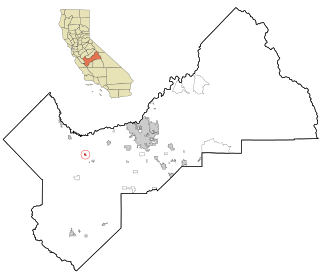
Tranquillity is a census-designated place (CDP) in Fresno County, California, United States. It is located 10 miles (16 km) southeast of Mendota, at an elevation of 164 feet (50 m). The population was 799 at the 2010 census, down from 813 at the 2000 census. Tranquillity High School is the only high school in Tranquillity.

<span class="mw-page-title-main">Bayview, Humboldt County, California</span> Census-designated place in California, United States

Bayview is a census-designated place (CDP) located adjacent to the City of Eureka in Humboldt County, California, United States. Its population is 2,619 as of the 2020 census, up from 2,510 from the 2010 census. Many locals consider this area as part of "Pine Hill."

<span class="mw-page-title-main">Redway, California</span> Census-designated place in California, United States

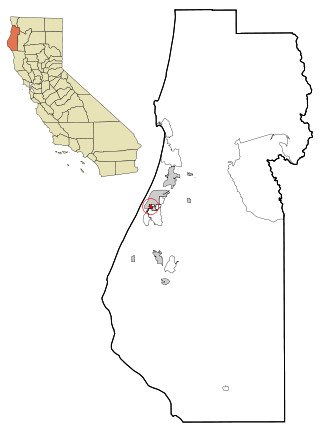
Redway is a census-designated place (CDP) in Humboldt County, California, United States. Redway is located 2.25 miles (3.6 km) northwest of Garberville, at an elevation of 538 feet (164 m). The population was 1,225 at the 2010 census, up from 1,188 at the 2000 census. Redway is also home to Redway Elementary School, with grades K–6.

<span class="mw-page-title-main">East San Gabriel, California</span> Census-designated place in California, United States

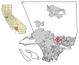
East San Gabriel is a census-designated place (CDP) in Los Angeles County, California, United States. The population was 14,874 at the 2010 census, up from 14,512 at the 2000 census.

<span class="mw-page-title-main">North El Monte, California</span> Census-designated place in California, United States

North El Monte is a census-designated place (CDP) in the San Gabriel Valley, in Los Angeles County, California, United States. The population was 3,723 at the 2010 census, up from 3,703 at the 2000 census.

<span class="mw-page-title-main">West Rancho Dominguez, California</span> Unincorporated community in California, United States

West Rancho Dominguez, formerly known as West Compton, is an unincorporated census-designated place (CDP) located in southern Los Angeles County, California. Per the 2020 census, the population was 24,347. The community lies to the west of the city of Compton. The ZIP Codes encompassing the CDP area are 90220 & 90248.

<span class="mw-page-title-main">North Auburn, California</span> Census-designated place in California, United States

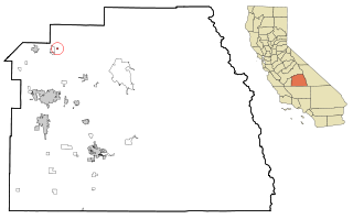
North Auburn is a census-designated place (CDP) in Placer County, California, United States. It is part of the Sacramento–Arden-Arcade–Roseville Metropolitan Statistical Area. The population was 13,452 at the 2020 census.

<span class="mw-page-title-main">Homeland, California</span> Census-designated place in California, United States

Homeland is a census-designated place (CDP) in Riverside County, California, United States. The population was 5,969 at the 2010 census, up from 3,710 at the 2000 census.

<span class="mw-page-title-main">Bluewater, California</span> Census-designated place in California, United States

Bluewater is a census-designated place (CDP) in San Bernardino County, California, United States. The population was 172 at the 2010 census, down from 265 at the 2000 census.

<span class="mw-page-title-main">Freedom, California</span> Census-designated place in California, United States

Freedom is a census-designated place (CDP) in Santa Cruz County, California, United States. The population was 3,070 at the 2010 census.

<span class="mw-page-title-main">East Orosi, California</span> Place in California, United States

East Orosi is a unincorporated community in Tulare County, California, United States. The population was 495 at the 2010 census, up from 426 in 2000. For statistical purposes, the United States Census Bureau has defined East Orosi as a census-designated place (CDP).

<span class="mw-page-title-main">Tipton, California</span> Census-designated place in California, United States

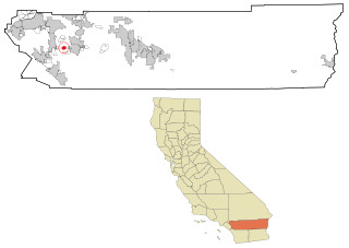
Tipton is a census-designated place (CDP) in Tulare County, California, United States. The population was 2,543 at the 2010 census, up from 1,790 at the 2000 census.

<span class="mw-page-title-main">Twain Harte, California</span> Census-designated place in California, United States

Twain Harte is a census-designated place (CDP) in Tuolumne County, California, United States. The population was 2,226 at the 2010 census, down from 2,586 at the 2000 census. Its name is derived from the last names of two famous authors who lived in California, Mark Twain and Bret Harte.

<span class="mw-page-title-main">Helena West Side, Montana</span> Census-designated place in Montana, United States

Helena West Side is a census-designated place (CDP) in Lewis and Clark County, Montana, United States. The population was 1,637 at the 2010 census, down from 1,711 at the 2000 census due to annexation of part of the CDP by the city of Helena. It is part of the Helena Micropolitan Statistical Area.

<span class="mw-page-title-main">West Brattleboro, Vermont</span> CDP in Vermont, United States

West Brattleboro is a census-designated place (CDP) in the town of Brattleboro, Vermont, United States. The population was 3,222 at the 2000 census.

<span class="mw-page-title-main">Hobart, Washington</span> Census-designated place in Washington, United States

Hobart is an unincorporated community and census-designated place (CDP) in King County, Washington, United States. The population was 6,767 at the 2020 census.

<span class="mw-page-title-main">West Valley, Washington</span> CDP in Washington, United States

West Valley is a former census-designated place (CDP) in Yakima County, Washington, United States. The area has been annexed by the city of Yakima. The population was 10,433 at the 2000 census.

References

  1. "2020 U.S. Gazetteer Files". United States Census Bureau. Retrieved October 30, 2021.
  2. "US Gazetteer files: 2010, 2000, and 1990". United States Census Bureau. February 12, 2011. Retrieved April 23, 2011.
  3. "Census of Population and Housing". Census.gov. Retrieved June 4, 2016.
  4. "2010 Census Interactive Population Search: CA - Bret Harte CDP". U.S. Census Bureau. Archived from the original on July 15, 2014. Retrieved July 12, 2014.
  5. "U.S. Census website". United States Census Bureau . Retrieved January 31, 2008.
  6. "Statewide Database". Regents of the University of California. Archived from the original on February 1, 2015. Retrieved March 27, 2015.
  7. "California's 10th Congressional District - Representatives & District Map". Civic Impulse, LLC. Retrieved September 28, 2014.