
The Mercator projection is a conformal cylindrical map projection first presented by Flemish geographer and mapmaker Gerardus Mercator in 1569. In the 18th century, it became the standard map projection for navigation due to its property of representing rhumb lines as straight lines. When applied to world maps, the Mercator projection inflates the size of lands the further they are from the equator. Therefore, landmasses such as Greenland and Antarctica appear far larger than they actually are relative to landmasses near the equator. Nowadays the Mercator projection is widely used because, aside from marine navigation, it is well suited for internet web maps.

Navigation is a field of study that focuses on the process of monitoring and controlling the movement of a craft or vehicle from one place to another. The field of navigation includes four general categories: land navigation, marine navigation, aeronautic navigation, and space navigation.

A compass is a device that shows the cardinal directions used for navigation and geographic orientation. It commonly consists of a magnetized needle or other element, such as a compass card or compass rose, which can pivot to align itself with magnetic north. Other methods may be used, including gyroscopes, magnetometers, and GPS receivers.

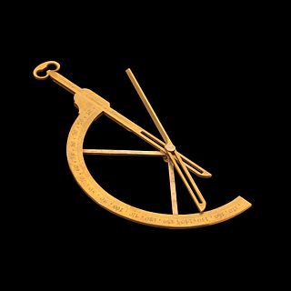
An astrolabe is an astronomical instrument dating to ancient times. It serves as a star chart and physical model of visible half-dome of the sky. Its various functions also make it an elaborate inclinometer and an analog calculation device capable of working out several kinds of problems in astronomy. In its simplest form it is a metal disc with a pattern of wires, cutouts, and perforations that allows a user to calculate astronomical positions precisely. It is able to measure the altitude above the horizon of a celestial body, day or night; it can be used to identify stars or planets, to determine local latitude given local time, to survey, or to triangulate. It was used in classical antiquity, the Islamic Golden Age, the European Middle Ages and the Age of Discovery for all these purposes.
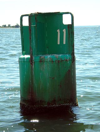
A buoy is a floating device that can have many purposes. It can be anchored (stationary) or allowed to drift with ocean currents.
A reference card or Romer is a device for increasing the accuracy when reading a grid reference from a map.

A nautical chart or hydrographic chart is a graphic representation of a sea region or water body and adjacent coasts or banks. Depending on the scale of the chart, it may show depths of water (bathymetry) and heights of land (topography), natural features of the seabed, details of the coastline, navigational hazards, locations of natural and human-made aids to navigation, information on tides and currents, local details of the Earth's magnetic field, and human-made structures such as harbours, buildings, and bridges. Nautical charts are essential tools for marine navigation; many countries require vessels, especially commercial ships, to carry them. Nautical charting may take the form of charts printed on paper or computerized electronic navigational charts. Recent technologies have made available paper charts which are printed "on demand" with cartographic data that has been downloaded to the commercial printing company as recently as the night before printing. With each daily download, critical data such as Local Notices to Mariners are added to the on-demand chart files so that these charts are up to date at the time of printing.
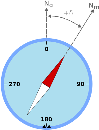
Magnetic declination is the angle between magnetic north and true north at a particular location on the Earth's surface. The angle can change over time due to polar wandering.
A goniometer is an instrument that either measures an angle or allows an object to be rotated to a precise angular position. The term goniometry derives from two Greek words, γωνία (gōnía) 'angle' and μέτρον (métron) 'measure'. The protractor is a commonly used type in the fields of mechanics, engineering, and geometry.

In navigation, the course of a watercraft or aircraft is the cardinal direction in which the craft is to be steered. The course is to be distinguished from the heading, which is the direction where the watercraft's bow or the aircraft's nose is pointed. The path that a vessel follows is called a track or, in the case of aircraft, ground track. The intended track is a route.

A bridge, or wheelhouse, is a room or platform of a ship, submarine, airship, or spaceship from which the ship can be commanded. When a ship is under way, the bridge is manned by an officer of the watch aided usually by an able seaman acting as a lookout. During critical maneuvers the captain will be on the bridge, often supported by an officer of the watch, an able seaman on the wheel and sometimes a pilot, if required.
Navigational instruments are instruments used by nautical navigators and pilots as tools of their trade. The purpose of navigation is to ascertain the present position and to determine the speed, direction, etc. to arrive at the port or point of destination.

A set square or triangle is an object used in engineering and technical drawing, with the aim of providing a straightedge at a right angle or other particular planar angle to a baseline.

The Yeoman Plotter was a plotter used on ships and boats to transfer GPS coordinates or RADAR echo locations onto a paper navigation chart and to read coordinates from the chart. It was manufactured from 1985 to 2014/2015 and was an intermediary step between traditional paper chart navigation and full electronic chart displays. It was easy to understand for people that were accustomed to paper charts and much cheaper than electronic chart displays available at the time. The continuing fall in prices of electronic chart displays, their increase in functionality such as radar overlay and the advent of cheap tablets eventually made the Yeoman plotter uncompetitive.
Jean Émile Paul Cras was a 20th-century French composer and career naval officer. His musical compositions were inspired by his native Brittany, his travels to Africa, and most of all, by his sea voyages. As a naval commander he served with distinction in the Adriatic Campaign during World War I.

Parallel rulers are a drafting instrument used by navigators to draw parallel lines on charts. The tool consists of two straight edges joined by two arms which allow them to move closer or further away while always remaining parallel to each other.
Marine electronics refers to electronics devices designed and classed for use in the marine environment on board ships and yachts where even a small amount of salt water can destroy some electronics devices. Therefore, the majority of these types of devices are either water resistant or waterproof.
Air Commodore Arthur Wellesley Bigsworth & Bar, AFC was a pioneer aviator who had a distinguished military career in the service of the British armed forces.

The C-Thru Ruler Company is an American maker of measuring devices and specialized products for drafting, designing and drawing. The company was formed in 1939 in Bloomfield, Connecticut, by Jennie R. Zachs, a schoolteacher, who saw the need for transparent measuring tools such as rulers, triangles, curves and protractors.
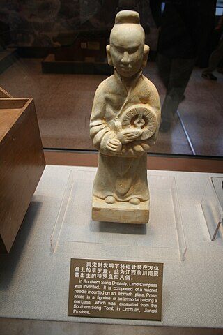
The compass is a magnetometer used for navigation and orientation that shows direction in regards to the geographic cardinal points. The structure of a compass consists of the compass rose, which displays the four main directions on it: East (E), South (S), West (W) and North (N). The angle increases in the clockwise position. North corresponds to 0°, so east is 90°, south is 180° and west is 270°.
