Lake Superior is the largest freshwater lake in the world by surface area and the third-largest by volume, holding 10% of the world's surface fresh water. Located in central North America, it is the northernmost and westernmost of the Great Lakes of North America, straddling the Canada–United States border with the Canadian province of Ontario to the north and east and the U.S. states of Minnesota to the west and Wisconsin and Michigan to the south. It drains into Lake Huron via St. Marys River, then through the lower Great Lakes to the St. Lawrence River and ultimately the Atlantic Ocean.
The Lower Peninsula of Michigan – also known as Lower Michigan – is the larger, southern and less elevated of the two major landmasses that make up the U.S. state of Michigan; the other being the Upper Peninsula, which is separated by the Straits of Mackinac. It is surrounded by water on all sides except its southern border, which it shares with Indiana and Ohio. Although the Upper Peninsula is commonly referred to as "the U.P.", it is uncommon for the Lower Peninsula to be called "the L.P."

The Upper Peninsulaof Michigan – also known as Upper Michigan or colloquially the U.P. – is the northern and more elevated of the two major landmasses that make up the U.S. state of Michigan; it is separated from the Lower Peninsula by the Straits of Mackinac. It is bounded primarily by Lake Superior to the north, separated from the Canadian province of Ontario at the east end by the St. Marys River, and flanked by Lake Huron and Lake Michigan along much of its south. Although the peninsula extends as a geographic feature into the state of Wisconsin, the state boundary follows the Montreal and Menominee rivers and a line connecting them.

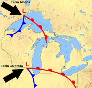
Lake-effect snow is produced during cooler atmospheric conditions when a cold air mass moves across long expanses of warmer lake water. The lower layer of air, heated by the lake water, picks up water vapor from the lake and rises through colder air. The vapor then freezes and is deposited on the leeward (downwind) shores.

Wexford County is a county in the Northern Lower Peninsula of the U.S. state of Michigan. As of the 2020 United States Census, the population was 33,673. The seat of Wexford County is Cadillac, which is also the county's largest city.

Gaylord is a city in and the county seat of Otsego County in the U.S. state of Michigan. Gaylord had a population of 4,286 at the 2020 census, an increase from 3,645 at the 2010 census.

Marquette Mountain Resort is a small mountain and ski resort in Marquette, Michigan, the major city in the state's Upper Peninsula. The resort offers winter sports seasonally as well as mountain biking, volleyball, and hiking in the spring, summer, and fall.

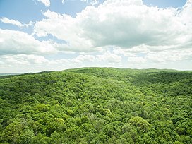
The Manistee National Forest is a national forest located in the Lower Peninsula of Michigan. It has a total area of 540,187 acres (2,190 km2). It was established in 1938, and combined with the Huron National Forest in 1945 for administrative purposes, creating the Huron-Manistee National Forests. However, they are two separate forest units, as they are not connected. The area is popular for hiking, fishing, camping, boating, snowmobiling, cross-country skiing and hunting. The North Country Trail passes through it, and connects with the 11-mile Manistee River Trail to form a 23-mile loop. The highest point in the lower peninsula, Briar Hill (1,706 ft), is located here. The Manistee National Forest is not one continuous mass, but is a "mosaic" broken by private property and towns. The headquarters for the forest is in Cadillac, Michigan.

Mount Nebo is the southernmost and highest mountain in the Wasatch Range of Utah, in the United States, and the centerpiece of the Mount Nebo Wilderness, inside the Uinta National Forest. It is named after the biblical Mount Nebo, overlooking Israel from the east of the Jordan river, which is said to be the place of Moses' death.

The climate of Chicago is classified as hot-summer humid continental. All four seasons are distinctly represented: Winters are cold and often see snow with below 0 Celsius temperatures and windchills, while summers are warm and humid with temperatures being hotter inland, spring and fall bring bouts of both cool and warm weather and fairly sunny skies. Annual precipitation in Chicago is moderate and relatively evenly distributed, the driest months being January and February and the wettest July and August. Chicago's weather is influenced during all four seasons by the nearby presence of Lake Michigan.
The Great Lakes Storm of 1913 was a blizzard with hurricane-force winds that devastated the Great Lakes Basin in the Midwestern United States and Southwestern Ontario, Canada, from November 7 to 10, 1913. The storm was most powerful on November 9, battering and overturning ships on four of the five Great Lakes, particularly Lake Huron.

Tug Hill, sometimes referred to as the Tug Hill Plateau, is an upland region in northern New York State, famous for heavy winter snows. The Tug Hill region is east of Lake Ontario, north of Oneida Lake, and west of the Adirondack Mountains. The region is separated from the Adirondacks by the Black River Valley.

Nokhu Crags is a rock formation and mountain summit in the Never Summer Mountains range of the Rocky Mountains of North America. The name is derived from the Arapaho language, Neaha-no-xhu, meaning "Eagles Nest." The 12,490-foot (3,807 m) peak is located in State Forest State Park, 2.5 miles (4.0 km) south of Cameron Pass in Jackson County, Colorado, United States. The summit lies just northwest of the Continental Divide and Rocky Mountain National Park, near the headwaters of the Michigan River. The peak is prominently visible from State Highway 14 and can be seen throughout the southern North Park basin where it is known also known as "the Crags" or "Sleeping Indian" for its resemblance to the form of a supine chief. To the east lie the shallow basins of Snow Lake and the Michigan or American Lakes; to the north lies a snow filled couloir; to the west the mountain descends directly into the deep waters of Lake Agnes; and to the south lie Static Peak, Mount Richthofen, and the remainder of the Never Summer Mountain Range.

Snowmass Mountain is a 14,099-foot-high (4,297 m) mountain in the U.S. state of Colorado, and the thirty-fourth highest mountain peak in the state. Located in the Elk Mountains within the Maroon Bells-Snowmass Wilderness of the White River National Forest, it lies along the border between Pitkin and Gunnison counties, west of Aspen and southwest of the town of Snowmass Village.
Snow River Mountain Resort is located in the Upper Peninsula of Michigan in Wakefield Township, Gogebic County. Indianhead Mountain is in an area called "Big Snow Country", so named because of the annual 200-inch (5.1 m) average snowfall, courtesy of the lake effect from Lake Superior. It consists of the Jackson Creek Summit, formerly Indianhead Mountain, and Black River Basin, formerly known as Blackjack.

Michigan consists of two peninsulas surrounded primarily by four of the Great Lakes and a variety of nearby islands. The Upper Peninsula is bounded on the southwest by Wisconsin, and the Lower Peninsula is bounded on the south by Indiana and Ohio. Both land masses are also separated from the Canadian province of Ontario by waterways of the Great Lakes, and from each other by the Straits of Mackinac. Because its land is largely surrounded by the Great Lakes, which flow into the Saint Lawrence River, Michigan is the only U.S. state whose streams and rivers are almost entirely within the Great Lakes-St. Lawrence watershed.

Huantsán,Huantsan or Tunsho is a mountain in the Andes of Peru. It is located in Ancash Region and is part of the Cordillera Blanca mountain range, a sub-range of the Andes. It has four peaks, with a maximum elevation of 6,369 metres (20,896 ft) above sea level.
Global weather activity of 2006 profiles the major worldwide weather events, including blizzards, ice storms, tropical cyclones, tornadoes, and other weather events, from January 1, 2006, to December 31, 2006. Winter storms are events in which the dominant varieties of precipitation are forms that only occur at cold temperatures, such as snow or sleet, or a rainstorm where ground temperatures are cold enough to allow ice to form. It may be marked by strong wind, thunder and lightning, heavy precipitation, such as ice, or wind transporting some substance through the atmosphere. Other major non winter events such as large dust storms, Hurricanes, cyclones, tornados, gales, flooding and rainstorms are also caused by such phenomena to a lesser or greater existent.
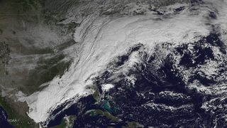
The November 13–21, 2014 North American winter storm was a potent winter storm and particularly severe lake-effect snowstorm that affected the United States, originating from the Pacific Northwest on November 13, which brought copious amounts of lake-effect snow to the Central US and New England from November 15 until November 21, when the system departed the East Coast of the United States. The snowstorm elicited an enormous response from emergency crews and the National Guard, requiring more manpower than any other snowstorm in the history of New York state, as it buried cars and stranded thousands of people in their homes in Western New York. Eight months after the storm, the snow's remnants still remained in Buffalo, New York.