
Iberville Parish is a parish located south of Baton Rouge in the U.S. state of Louisiana, formed in 1807. The parish seat is Plaquemine. The population was 30,241 at the 2020 census.
Whitewater Region is a township on the Ottawa River in Renfrew County, located within the scenic Ottawa Valley in eastern Ontario, Canada. Whitewater Region is made up of the former municipalities of Beachburg, Cobden, Ross and Westmeath, which were amalgamated into the current township on January 1, 2001.

Highway 9, the Agassiz-Rosedale Highway, is a north-south route in the eastern part of the Fraser Valley. It acts as the last connection between the Trans Canada Highway and the Lougheed Highway eastbound before Hope, and is the main access to the resort village of Harrison Hot Springs. The highway first opened in 1953, originally going between Yale Road in Rosedale and Highway 7, with a ferry across the Fraser River. A bridge for Highway 9 across the Fraser opened in 1956. When the section of Highway 1 east of Chilliwack opened in 1961, Highway 9 was extended south to a junction with the new Highway 1 alignment, which replaced Yale Road as the main route between Chilliwack and Hope.

Bridal Veil Falls Provincial Park is a BC Park located on the Trans-Canada Highway just east of Rosedale, British Columbia, Canada, part of the City of Chilliwack. The community of Bridal Falls is located adjacent to the falls and park as well as the interchange between the Trans-Canada and BC Highway 9 and has a variety of highway-based tourism services. Access to the falls requires a short hike from the parking lot and well groomed trails, taking most groups 15-25 minutes.

The Fraser Valley Regional District (FVRD) is a regional district in British Columbia, Canada. Its headquarters are in the city of Chilliwack. The FVRD covers an area of 13,361.74 km² (5,159 sq mi). It was created in 1995 by an amalgamation of the Fraser-Cheam Regional District and Central Fraser Valley Regional District and the portion of the Dewdney-Alouette Regional District from and including the District of Mission eastwards.

The Albion Ferry was a passenger and vehicle ferry service that sailed on the Fraser River between Albion and Fort Langley in the Lower Fraser Valley region of British Columbia, Canada from June 2, 1957, until July 31, 2009.

Bridal Veil Falls is a 607-foot-tall (185 m) double cataract waterfall in the south end of Provo Canyon, close to US189 in Utah, United States. Battle Creek Falls is on a nearby mountain side, approximately 10 miles north of Bridal Veil Falls.

The Bridal Veil Falls is a waterfall located on Bridal Veil Creek along the Columbia River Gorge in Multnomah County, Oregon, United States. The waterfall is accessible from the historic Columbia River Highway and Interstate 84. Spanning two tiers on basalt cliffs, it is the only waterfall which occurs below the historic Columbia Gorge Scenic Highway. The Bridal Veil Falls Bridge, built in 1914, crosses over the falls, and is listed on the National Register of Historic Places.
Coldwater River Provincial Park is a provincial park in British Columbia, Canada, located at the confluence of the Coldwater River with Cullet Creek, 50 km south of Merritt on BC Highway 5.
Ferry Island Provincial Park is a Class C provincial park in British Columbia that is located on the south side of the Fraser River northeast of Rosedale. This park is northwest of Bridal Falls, British Columbia and adjacent to the Agassiz-Rosedale Bridge. The Ferry Island Park was established in 1963, and it has an area of about 29 hectares.
Rosedale is a farming-based community located east of Chilliwack, British Columbia. This small community is based alongside the Fraser River. It serves as a base for many tourists, both in summer and winter. The hills and valleys of British Columbia are popular for tourists who enjoy outdoor activities such as skiing, snowboarding and dogsledding locations. In summer, rockclimbing and whitewater rafting are the primary activities in the Fraser Valley.

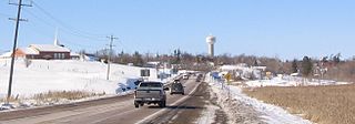
Agassiz is a small community located in the Eastern Fraser Valley region of British Columbia, Canada, about 97 kilometres east of Vancouver and 24 kilometres north-east of the city of Chilliwack. The only town within the jurisdiction of the District Municipality of Kent, it contains the majority of Kent's population.
The Lower Similkameen Indian Band or Lower Smelqmix, is a First Nations band government in the Canadian province of British Columbia. Their office was in the village of Keremeos in the Similkameen region, until 2015 when they moved into their own $7million multi-purpose facility south of Cawston. They are a member of the Okanagan Nation Alliance.
Little River is a community in the Comox Valley region of Vancouver Island, British Columbia, Canada.

Bridal Veil Falls is a 1,328-foot (405 m) waterfall that flows from Lake Serene directly to the South Fork Skykomish River on the creek of the same name in the U.S. state of Washington. It is a perennial 150-foot (46 m) wide drop with four tiers, two of which are clearly visible. It is at 47.78950°N 121.56924°W.
The Agassiz–Rosedale Bridge is a cantilever truss bridge across the Fraser River in the Fraser Valley region of southwestern British Columbia. Linking Agassiz with the south shore, the two-lane bridge carrying BC Highway 9 is by road about 36 kilometres (22 mi) west of Hope, 119 kilometres (74 mi) east of Vancouver, and 51 kilometres (32 mi) east of Abbotsford.
The Swift River is a river that begins in Yukon Territory and flows southwest into British Columbia to its mouth at the east side of Teslin Lake on the Teslin River system. The river drains the uppermost portion of the Cassiar Mountains and in its lower reaches traverses the Nisutlin Plateau, which lies along the east side of Teslin Lake north of the mouth of the Jennings River, which is to the south of the Swift.
The New Westminster Land District is one of 59 land districts of British Columbia, Canada, which are the underlying cadastral divisions of that province, created with rest of those on Mainland British Columbia via the Lands Act of the Colony of British Columbia in 1860. The British Columbia government's BC Names system, a subdivision of GeoBC, defines a land district as "a territorial division with legally defined boundaries for administrative purposes". All land titles and surveys use the Land District system as the primary point of reference, and entries in BC Names for placenames and geographical objects are so listed.
Dinotown was a dinosaur theme park in British Columbia, Canada, which operated from 1975 to 2010. Originally located in the lower Cultus Lake area and close to Bridal Falls in Chilliwack, B.C., Canada, it opened under the name Bedrock City and based around The Flintstones licensing. It reopened in 1995 under non-licensed dinosaur theming, and closed in 2010. From 2011 onwards, some temporary Dinotown exhibits operated in other locations. As of April 2021, they are "currently in discussions with multiple lower mainland locations including Vancouver, Surrey, New Westminster and Richmond to re-open the park on a permanent basis.

The Old Yale Road is a historic early wagon road between New Westminster, British Columbia, Canada and Yale, British Columbia, and servicing the Fraser Valley of the British Columbia Lower Mainland in the late 19th century and into the early 20th. It eventually became an early highway route for automobiles through the valley and into the British Columbia interior beyond Yale. It would eventually be part of, then surpassed by, the Fraser Highway, the Trans-Canada Highway and the Highway 1.
