
The San Juan Mountains is a high and rugged mountain range in the Rocky Mountains in southwestern Colorado and northwestern New Mexico. The area is highly mineralized and figured in the gold and silver mining industry of early Colorado. Major towns, all old mining camps, include Creede, Lake City, Silverton, Ouray, and Telluride. Large scale mining has ended in the region, although independent prospectors still work claims throughout the range. The last large-scale mines were the Sunnyside Mine near Silverton, which operated until late in the 20th century, and the Idarado Mine on Red Mountain Pass, which closed in the 1970s. Famous old San Juan mines include the Camp Bird and Smuggler Union mines, both located between Telluride and Ouray.

Telluride is the county seat and most populous town of San Miguel County in the southwestern portion of the U.S. state of Colorado. The town is a former silver mining camp on the San Miguel River in the western San Juan Mountains. The first gold mining claim was made in the mountains above Telluride in 1875, and early settlement of what is now Telluride followed. The town was founded in 1878 as "Columbia", but due to confusion with a California town of the same name, was renamed Telluride in 1887 for the gold telluride minerals found in other parts of Colorado. These telluride minerals were never found near Telluride, but the area's mines for some years provided zinc, lead, copper, silver, and other gold ores.
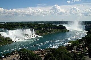
Niagara Falls is a group of three waterfalls at the southern end of Niagara Gorge, spanning the border between the province of Ontario in Canada and the state of New York in the United States. The largest of the three is Horseshoe Falls, which straddles the international border of the two countries. It is also known as the Canadian Falls. The smaller American Falls and Bridal Veil Falls lie within the United States. Bridal Veil Falls is separated from Horseshoe Falls by Goat Island and from American Falls by Luna Island, with both islands situated in New York.

San Miguel County is a county located in the U.S. state of Colorado. As of the 2020 census, the population was 8,072. The county seat is Telluride. The county is named for the San Miguel River.

Ouray is a home rule municipality that is the county seat of Ouray County, Colorado, United States. The city population was 898 as of the 2020 census. The Ouray Post Office has the ZIP Code 81427. Located at an elevation of 7,792 feet (2,375 m), Ouray's climate, natural alpine environment, and scenery have earned it the nickname "Switzerland of America".

Ice climbing is a climbing discipline that involves ascending routes consisting of frozen water. To ascend the route, the ice climber uses specialist equipment, particularly double ice axes and rigid crampons. To protect the route, the ice climber uses steel ice screws that require skill to employ safely and rely on the ice holding firm in any fall. Ice climbing routes can vary significantly by type, and include seasonally frozen waterfalls, high permanently frozen alpine couloirs, and large hanging icicles.

The San Miguel River is a tributary of the Dolores River, approximately 81 miles (130 km) long, in southwestern Colorado in the United States. It rises in the San Juan Mountains southeast of Telluride and flows northwest, along the southern slope of the Uncompahgre Plateau, past the towns of Placerville and Nucla and joins the Dolores in western Montrose County approximately 15 miles (24 km) east of the state line with Utah.

Bridal Veil Falls Provincial Park is a BC Park located on the Trans-Canada Highway just east of Rosedale, British Columbia, Canada, part of the City of Chilliwack. The community of Bridal Falls is located adjacent to the falls and park as well as the interchange between the Trans-Canada and BC Highway 9 and has a variety of highway-based tourism services. Access to the falls requires a short hike from the parking lot and well groomed trails, taking most groups 15-25 minutes.

Bridal Veil Falls is a 607-foot-tall (185 m) double cataract waterfall in the south end of Provo Canyon, close to US189 in Utah, United States. Battle Creek Falls is on a nearby mountain side, approximately 10 miles north of Bridal Veil Falls.

Uncompahgre National Forest is a U.S. National Forest covering 955,229 acres in parts of Montrose, Mesa, San Miguel, Ouray, Gunnison, Hinsdale, San Juan, and Delta Counties in western Colorado. Its headquarters are in Delta County, in the city of Delta. It borders the San Juan National Forest to the south.

The Idarado Mine was a mining operation in the San Juan Mountains of Ouray County, Colorado near the now-ghost town of Guston, producing primarily lead, silver and zinc along with lesser amounts of gold and copper. The mine is within the Sneffels-Red Mountain-Telluride mining district. The remains of the operation are visible from the Million Dollar Highway, north of Red Mountain Pass, between Ouray and Silverton, Colorado. The tunnels of the Idarado extend some 5 miles (8 km) west under 13,000 foot mountains to the Pandora Mill near Telluride, a trip of more than 60 miles (100 km) by highway.

The Ames Hydroelectric Generating Plant, constructed in 1890 near Ophir, Colorado, was one of the first commercial system to produce and transmit alternating current (AC) electricity for industrial use and one of the first AC hydro-electric plants ever constructed. It became operational in 1891 and was built by Westinghouse Electric around two of their large alternators. One was set up in the valley as a generator and driven by water. It was connected by a 2.6-mile (4.2 km) transmission line to the second alternator used as a motor up at the Gold King Mine to drive the mining operation. The facility has been changed and upgraded over the years but is still in operation. It is now on the List of IEEE Milestones.

Jeff Lowe was a famed American alpinist from Ogden, Utah who was known for his visionary climbs and first ascents established in the US and Canadian Rockies, Alps and Himalayas.

The Ouray Hydroelectric Power Plant is a conventional hydroelectric power station located in Ouray, Colorado.
Jack Roberts was an American rock and ice climber.
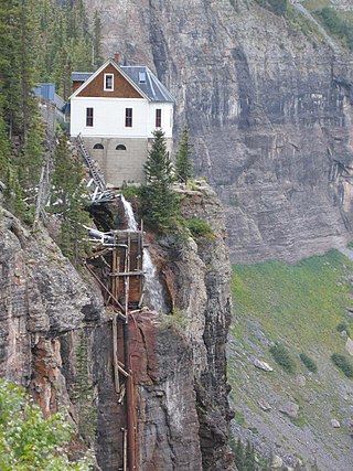
The Smuggler-Union Hydroelectric Powerplant, also known as the Bridal Veil Powerhouse, is an electric power generation plant and residence located next to Bridal Veil Falls on a 400-foot (120 m) cliff overlooking Telluride, Colorado. The structure is 2+1⁄2 stories on a poured concrete foundation with a wood frame superstructure. It consists of a main power plant building, a 1+1⁄2-story residence and a 1-story cookhouse. The power plant foundation is distinctive, with semicircular windows. A semicircular bay with arched windows projects out on a rock spur.
Pandora is an unincorporated community located 1.5 miles (2.4 km) east of Telluride in San Miguel County, Colorado.

The Salmon River Falls is a 110-foot (34 m) waterfall on the Salmon River in Oswego County, New York in the United States. It is located approximately 15 miles inland from the river's confluence with Lake Ontario within the 112-acre (0.45 km2) Salmon River Falls Unique Area, which is managed by the New York State Department of Environmental Conservation. The falls and surrounding land are open to the public and are a popular sightseeing destination within the region.

Ajax Peak is a 12,785-foot-elevation (3,897-meter) mountain summit located in San Miguel County of southwest Colorado, United States. It is situated on land managed by Uncompahgre National Forest, and is the iconic landmark visible three miles east of the community of Telluride. Ajax is set immediately south of Savage Basin and the ghost town of Tomboy, one mile southwest of Chicago Peak, and one mile west of Telluride Peak. It is also immediately northeast of Bridal Veil Falls, Colorado's highest waterfall at 365-feet high. It is part of the San Juan Mountains which are a subset of the Rocky Mountains. Topographic relief is significant as the west aspect rises 3,800 feet above the box canyon in approximately one mile. The old mill town of Pandora at the base of Ajax Peak was hit by snow slides each winter, and one particularly bad event in 1884 came over the Ajax Mine and wrecked the mills.


