
The Vale of Glamorgan, often referred to as The Vale, is a county borough in the south-east of Wales. It borders Bridgend County Borough to the west, Cardiff to the east, Rhondda Cynon Taf to the north, and the Bristol Channel to the south. With an economy based largely on agriculture and chemicals, it is the southernmost unitary authority in Wales. Attractions include Barry Island Pleasure Park, the Barry Tourist Railway, Medieval wall paintings in St Cadoc's Church, Llancarfan, Porthkerry Park, St Donat's Castle, Cosmeston Lakes Country Park and Cosmeston Medieval Village. The largest town is Barry. Other towns include Penarth, Llantwit Major, and Cowbridge. There are many villages in the county borough.

Rhondda Cynon Taf is a county borough in the south-east of Wales. It consists of five valleys: the Rhondda Fawr, Rhondda Fach, Cynon, Taff and Ely valleys, plus a number of towns and villages away from the valleys.

Bridgend is a town in the Bridgend County Borough of Wales, 20 miles (32 km) west of Cardiff and 20 miles (32 km) east of Swansea. The town is named after the medieval bridge over the River Ogmore. The River Ewenny also flows through the town. The population was 49,597 in 2021. Bridgend is within the Cardiff Capital Region which in 2019 had a population of approximately 1.54 million.

Porthcawl ( ) is a town and community in the Bridgend County Borough of Wales. It is on the south coast of Wales, 25 miles (40 km) west of Cardiff and 19 miles (31 km) southeast of Swansea.

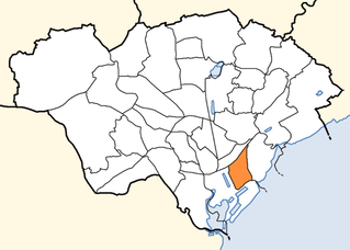
Bridgend County Borough is a county borough in the south-east of Wales. The county borough has a total population of 139,200 people, and contains the town of Bridgend, after which it is named. Its members of the Senedd are Sarah Murphy MS, representing the Bridgend Constituency, and Huw Irranca-Davies MS representing the Ogmore Constituency, and its members of the UK parliament are Jamie Wallis and Chris Elmore.
Kenfig is a village and former borough in Bridgend, Wales. It is situated 1 mile (1.6 km) inland on the north bank of the Bristol Channel, and just south-west of the M4 motorway. To the east is the town of Bridgend, at approximately 6 miles (10 km), and the capital city of Cardiff, at 24 miles (40 km). To the west lies Port Talbot, at approximately 7 miles, and Swansea at approximately 18 miles.
Splott is a district and community in the south of the city of Cardiff, capital of Wales, just east of the city centre. It was built up in the late 19th century on the land of two farms of the same name: Upper Splott and Lower Splott Farms. Splott is characterised by its once vast steelworks and rows of tightly knit terraced houses. The suburb of Splott falls into the Splott electoral ward.

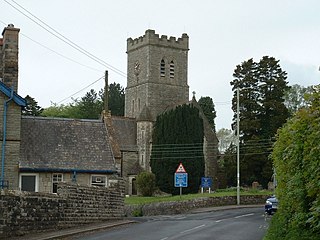
Merthyr Mawr is a village and community in Bridgend, Wales. The village is about 2+1⁄2 miles from the centre of Bridgend town. The population of the community at the 2011 census was 267. The community occupies the area west of the Ewenny River, between Bridgend and Porthcawl. It takes in the settlement of Tythegston and a stretch of coastal sand dunes known as Merthyr Mawr Warren. It is in the historic county of Glamorgan.
Brackla is a large housing estate and community in the east of Bridgend in Bridgend County Borough, Wales. Along with the communities of Bridgend and Coychurch Lower, it makes up the town of Bridgend.

The River Garw runs for about 12 miles from its source in the hills north of Blaengarw to the confluence with the River Ogmore and the River Llynfi at Aberkenfig. It is one of three main tributaries of the River Ogmore which runs through the town of Bridgend. It is in Wales, United Kingdom.
ROF Bridgend,, located in Bridgend, South Wales, was one of the largest of sixteen World War II, UK government-owned, Royal Ordnance Factory munitions Filling Factories. Of great significance to the Britain's war effort, at its peak of production it employed around 40,000 people — said to be the largest ever factory in Britain's history.

Pyle is a village and community in Bridgend county borough, Wales. This large village is served by the A48 road, and lies less than one mile from Junction 37 of the M4 motorway, and is therefore only a half-hour journey from the capital city of Wales, Cardiff. The nearest town is the seaside resort of Porthcawl. Within the Community, to the northeast of Pyle, is the adjoining settlement of Kenfig Hill, North Cornelly also adjoins Pyle and the built-up area had a population of 13,701 in 2011.
The Swansea Enterprise Park is a combined business park, retail park and industrial estate in Swansea, Wales. In 1981 it became the first enterprise zone in the United Kingdom, and the largest. Originally it was named the Swansea Enterprise Zone. The designated area covers parts of the Llansamlet and Morriston wards in the Lower Swansea valley, Wales. The Enterprise Park is the largest commercial district and the largest out-of-town shopping district of Swansea. Major employers at the site include Morganite, Alberto-Culver, Viskase, The Land Registry and Welsh Water.

The A4119 links Tonypandy with Cardiff in South Wales.

South Wales Fire and Rescue Service is the fire and rescue service covering the ten Welsh principal areas of Blaenau Gwent, Bridgend, Caerphilly, Cardiff, Merthyr Tydfil, Monmouthshire, Newport, Rhondda Cynon Taf, Torfaen and Vale of Glamorgan.
Pen-y-fai is a village in the county borough of Bridgend, Wales within the Bridgend electoral ward area and the community of Newcastle Higher. The ward population taken at the 2011 census was 2,447.

The Ewenny River is a river in South Wales. For most of its 10 miles (16 km) length, it forms the border between the Vale of Glamorgan and Bridgend. It is a major tributary of the River Ogmore, which it joins near its estuary.
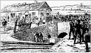
Parc Slip Colliery was a coal mine near situated at Aberkenfig, near Tondu in Bridgend County Borough, Wales.
Waterton is an area south of Bridgend, Wales. It is mainly an industrial zone, as it is home to Bridgend Industrial Estate, Waterton Industrial Estate, Waterton Park, the Ford Engine Plant & Waterton Retail Park. CGI Inc., the Global IT and business services company are located at Waterton Industrial Estate

The B4265 road is a main road in the Vale of Glamorgan, southeastern Wales, running in a northwesterly direction along near the coast. It links Cardiff Airport to Bridgend, lasting for 15.9 miles (25.6 km). The road begins at the roundabout near the airport and the village of Penmark at 51°24′21″N3°20′39″W as a continuation of the A4226 road leading from Barry. Passing the junction turnoff to Gileston and St Athan, at Llantwit Major, the B4270 road branches off to the northwest to Llandow Industrial Estate. The road then moves progressively in northwesterly direction until St Brides Major, where the B4524 road to the south connects it to Southerndown and Ogmore-by-Sea. At St Brides Major, the road shifts to a northerly direction, where it passes Ewenny and Ogmore village leading to Bridgend, where it joins the A48 road and finally A473 road at 51°30′7″N3°34′34″W.