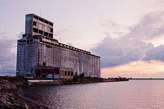
A grain elevator is a facility designed to stockpile or store grain. In the grain trade, the term "grain elevator" also describes a tower containing a bucket elevator or a pneumatic conveyor, which scoops up grain from a lower level and deposits it in a silo or other storage facility.

The Doukhobours or Dukhobors are a Spiritual Christian ethnoreligious group of Russian origin. They are known for their pacifism and tradition of oral history, hymn-singing, and verse. They reject the Russian Orthodox priesthood and associated rituals, believing that personal revelation is more important than the Bible. Facing persecution by the Russian government for their nonorthodox beliefs, many migrated to Canada between 1899 and 1938, where most currently reside.

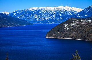
The Kootenay or Kootenai river is a major river in the Northwest Plateau, in southeastern British Columbia, Canada, and northern Montana and Idaho in the United States. It is one of the uppermost major tributaries of the Columbia River, the largest North American river that empties into the Pacific Ocean. The Kootenay River runs 781 kilometres (485 mi) from its headwaters in the Kootenay Ranges of the Canadian Rockies, flowing from British Columbia's East Kootenay region into northwestern Montana, then west into the northernmost Idaho Panhandle and returning to British Columbia in the West Kootenay region, where it joins the Columbia at Castlegar.

Castlegar is the second-largest community in the West Kootenay region of British Columbia, Canada. In the Selkirk Mountains, at the confluence of the Kootenay and Columbia Rivers, it is a regional trade and transportation centre, with a local economy based on forestry, mining and tourism.
New Denver is at the mouth of Carpenter Creek, on the east shore of Slocan Lake, in the West Kootenay region of southeastern British Columbia. The village is 47 kilometres (29 mi) west of Kaslo on Highway 31A, and 47 kilometres (29 mi) southeast of Nakusp and 32 kilometres (20 mi) northeast of Slocan on Highway 6.
The Freedomite movement consists of a split-off of the Doukhobors, a community of Spiritual Christians began a mass migration from Russia to Canada in 1898. The Freedomite movement first appeared in 1902 in Saskatchewan, and later in the Kootenay and Boundary Districts of British Columbia.

The Sinixt are a First Nations People. The Sinixt are descended from Indigenous peoples who have lived primarily in what are today known as the West Kootenay region of British Columbia in Canada and the adjacent regions of Eastern Washington in the United States for at least 10,000 years. The Sinixt are of Salishan linguistic extraction, and speak their own dialect (sn-selxcin) of the Colville-Okanagan language.
Kootenay Lake Crossing is a powerline crossing of Kootenay Lake, British Columbia, Canada. The idea was to transport electricity from the Hydro dam on the Kootenay River at Brilliant to the Cominco Sullivan Mine at Kimberley. The most direct route was across Kootenay Lake. Originally it was with a span width of 3,248 metres (10,656 ft) the longest powerline span of North America and fixed on three - for each conductor a single one - 19 metres tall towers at the west shore and a 112 metres (367 ft) tall electricity pylon on the east shore. This tower was erected in spite of high mountains on the east shore for building short towers were available, as erecting span terminal towers on them would have required a longer span, for which the use of spliced conductors were required, which was undesired as the splicing point is a potential point of failure. Roebling cable provided the steel support cable for the conductor. The height of conductor over Kootenay Lake was 37 metres (121 ft).
Winlaw is an unincorporated community adjacent to Winlaw Creek on the east side of the Slocan River in the West Kootenay region of southeastern British Columbia. The locality is on BC Highway 6 about 20 kilometres (12 mi) south of Slocan, and 49 kilometres (30 mi) north of Castlegar.
FortisBC is a Canadian owned, British Columbia based regulated utility focused on providing safe and reliable energy, including natural gas, Renewable Natural Gas, electricity and propane. FortisBC has approximately 2,600 employees serving more than 1.2 million customers in 135 B.C. communities and 58 First Nations communities across 150 Traditional Territories.
The Slocan Valley is a valley in the West Kootenay region of southeastern British Columbia.
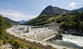
Brilliant Dam is a hydroelectric dam on the Kootenay River near Castlegar, British Columbia, Canada. It was built during the Second World War, mostly by Doukhobour men exempt from military service, and its 129 MW twin turbines first came into operation in June, 1944. The Columbia Power Corporation purchased the dam from Teck Cominco in 1996.
Raspberry is an unincorporated community in the West Kootenay region of southeastern British Columbia. On the northeast side of the Columbia River adjacent to the mouth of Norns Creek, the residential area is part of Greater Castlegar.
Ootischenia is south of Castlegar on the east side of the Columbia River in the West Kootenay region of southern British Columbia.

Corra Linn Dam is a concrete hydroelectric dam on the Kootenay River between the cities of Castlegar and Nelson, in the West Kootenay region of southern British Columbia.
Tarrys is an unincorporated community spanning both shores of the Kootenay River in the West Kootenay region of southeastern British Columbia. The location, on BC Highway 3A, is by road about 14 kilometres (9 mi) northeast of Castlegar, and 30 kilometres (19 mi) southwest of Nelson.

The Cotter Dam is a concrete gravity and rockfill embankment dam across the Cotter River, located in the Australian Capital Territory, Australia. Both the dam and river are named after early settler in the area Garrett Cotter. The impounded Cotter Reservoir is a supply source of potable water for the city of Canberra and its environs.
Pass Creek is an unincorporated community on the east side of Norns Creek in the West Kootenay region of southeastern British Columbia. The rural neighbourhood on Pass Creek Rd is about 11 kilometres (7 mi) north of Castlegar.
Champion Creek is a ghost town located in the West Kootenay region of British Columbia. It is a former Doukhobor settlement. The town is near Champion Creek on the east side of Columbia River, between Trail and Castlegar.
Krestova is a unincorporated community of about 150 people in the Kootenay region of British Columbia, Canada. The community was established by members of the Doukhobor religious group, who originally immigrated from Ukraine and Russia, in 1911-12. The name comes from the Russian "Dolina Krestova ", meaning "valley of the cross". The area is still home to the "Sons of Freedom" movement, which split from the Doukhobor community in the early 1900s.
