
Cheshire is a ceremonial county in North West England. It is bordered by Merseyside to the north-west, Greater Manchester to the north-east, Derbyshire to the east, Staffordshire to the south-east, and Shropshire to the south; to the west it is bordered by the Welsh counties of Flintshire and Wrexham, and has a short coastline on the Dee Estuary. Warrington is the largest settlement, and the city of Chester is the county town.

The Cheshire Cat is a fictional cat popularised by Lewis Carroll in Alice's Adventures in Wonderland and known for its distinctive mischievous grin. While now most often used in Alice-related contexts, the association of a "Cheshire cat" with grinning predates the 1865 book. It has transcended the context of literature and become enmeshed in popular culture, appearing in various forms of media, from political cartoons to television, as well as in cross-disciplinary studies, from business to science. Often it is shown in the context of a person or idea that is purposefully confusing or enigmatic. One distinguishing feature of the Alice-style Cheshire Cat is the periodic gradual disappearance of its body, leaving only one last visible trace: its iconic grin. He belongs to the Duchess.

Chester is a cathedral city and the county town of Cheshire, England, on the River Dee, close to the England-Wales border. With a population of 79,645 in 2011, it is the most populous settlement of Cheshire West and Chester and serves as its administrative headquarters. It is also the historic county town of Cheshire and the second-largest settlement in Cheshire after Warrington.

Lyme Park is a large estate south of Disley, Cheshire, England, managed by the National Trust and consisting of a mansion house surrounded by formal gardens and a deer park in the Peak District National Park. The house is the largest in Cheshire, and is recorded in the National Heritage List for England as a designated Grade I listed building.

Birkenhead is a town in the Metropolitan Borough of Wirral, Merseyside, England; historically, it was part of Cheshire until 1974. The town is on the Wirral Peninsula, along the west bank of the River Mersey, opposite Liverpool. At the 2011 census, it had a population of 88,818.

Hoylake is a seaside town in the Metropolitan Borough of Wirral, Merseyside, England. It is at the north west of the Wirral Peninsula, near West Kirby and where the River Dee meets the Irish Sea. Historically part of Cheshire, the Domesday Book of 1086 recorded it within the Hundred of Wilaveston.

Stockton Heath is a civil parish and suburb of Warrington, in the Borough of Warrington, Cheshire, England. It is located to the north of the Bridgewater Canal and to the south of the Manchester Ship Canal, which divides Stockton Heath from Latchford and north Warrington. It has a total resident population of 6,396.

Pensby is a large village on the Wirral Peninsula, in Merseyside, England. It is located 1.5 miles (2.4 km) to the north of the town of Heswall and approximately 0.5 miles (0.80 km) to the south west of Thingwall. Historically within Cheshire, the area is part of the Pensby and Thingwall Ward of the Metropolitan Borough of Wirral and is in the parliamentary constituency of Wirral West.

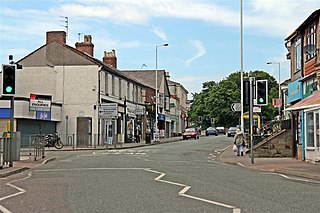
New Ferry is an urban area on the Metropolitan Borough of Wirral, Merseyside, England. It is located on the Wirral Peninsula, with the River Mersey to the east and the town of Bebington to the west. Within the boundaries of the historic county of Cheshire, the area was developed from the early nineteenth century.

Heswall is a town on the Wirral Peninsula, Merseyside, England and a ward of the Metropolitan Borough of Wirral. Before local government reorganisation on 1 April 1974 it was part of Cheshire.

Tranmere is a suburb of Birkenhead, on the Wirral Peninsula, England. Administratively, it is within the Birkenhead and Tranmere Ward of the Metropolitan Borough of Wirral, in Merseyside. Before local government reorganisation on 1 April 1974, it was part of the County Borough of Birkenhead, within the geographical county of Cheshire.
Upton is a village in the northern part of the Wirral Peninsula, England, and is situated within 4 miles (6.4 km) of Birkenhead, 4 miles (6.4 km) of the Dee Estuary, a similar distance from the River Mersey, and 2 miles (3.2 km) from Liverpool Bay. The village is a ward of the Metropolitan Borough of Wirral in the metropolitan county of Merseyside. Upton was in the traditional county of Cheshire. At the 2011 census, the population was 16,130.

The Wirral Peninsula, known locally as The Wirral, is a peninsula in North West England. The roughly rectangular peninsula is about 15 miles (24 km) long and 7 miles (11 km) wide, and is bounded by the Dee Estuary to the west, the Mersey Estuary to the east, and Liverpool Bay to the north.

Birkenhead Priory is in Priory Street, Birkenhead, Merseyside, England. It is the oldest standing building on Merseyside. The site comprises the medieval remains of the priory itself, the priory chapter house, and the remains of St Marys church. All three are recorded in the National Heritage List for England, though at different grades.

Greasby is a large village on the Wirral Peninsula, Merseyside, England. A predominantly residential area, it is contiguous with Upton to the east and Saughall Massie to the north. The small village of Frankby is to the immediate west. Historically within the county of Cheshire, it is part of the Greasby, Frankby and Irby Ward of the Metropolitan Borough of Wirral and is in the parliamentary constituency of Wirral West.

Thornton Hough is a village and former civil parish in the Wirral district of Merseyside, England. The village lies in the more rural inland part of the Wirral Peninsula and is of pre-Norman Conquest origins. The village grew during the ownership of Joseph Hirst into a small model village and was later acquired by William Lever, founder of Lever Brothers, the predecessor of Unilever. Thornton Hough is roughly 10 miles (16 km) from Liverpool and 12 miles (19 km) from Chester. It is part of the Clatterbridge ward and is in the parliamentary constituency of Wirral South.
Woodchurch is an area of Birkenhead on the Wirral Peninsula, in England. Administratively, Woodchurch is within the Metropolitan Borough of Wirral, its parliamentary constituency is Wirral West, and its local council ward is Upton. At the 2001 Census, it had a population of 8,400. Woodchurch is dominated by a large housing development, known as the Woodchurch Estate. The district is served by several schools and has the major Arrowe Park Hospital just outside its boundary, which was built on 15 acres (61,000 m2) of the park itself and opened in 1982.

Hooton is a suburban village and former civil parish on the Wirral Peninsula, within the unitary authority of Cheshire West and Chester and the ceremonial county of Cheshire, England. It was once a separate village but was incorporated into Ellesmere Port as the town expanded outwards during the twentieth century.

Brimstage is a village and former civil parish in the Wirral district, in the county of Merseyside, England. It is in the centremost part of the Wirral Peninsula, approximately 3 miles (4.8 km) east of Heswall and 3 miles (4.8 km) south west of Bebington. Administratively, it is within the Clatterbridge Ward and is in the parliamentary constituency of Wirral South.
Macclesfield Castle was a fortified manor house in Macclesfield, Cheshire. John de Macclesfield began construction of the castle in 1398. It was made from sandstone, and was square with projecting wings. Alterations were made in the 15th century, and it passed through the hands of two families of earls. By 1585 the building was ruinous, and all that survived to the 20th century was the porch. This was dismantled in 1932, and the site reused for cottages and shops.
