
Lindisfarne, also called Holy Island, is a tidal island off the northeast coast of England, which constitutes the civil parish of Holy Island in Northumberland. Holy Island has a recorded history from the 6th century AD; it was an important centre of Celtic Christianity under Saints Aidan, Cuthbert, Eadfrith, and Eadberht of Lindisfarne. After the Viking invasions and the Norman conquest of England, a priory was re-established. A small castle was built on the island in 1550.
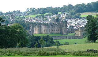
Alnwick is a market town in Northumberland, England, of which it is the traditional county town. The population at the 2011 Census was 8,116.

The River Coquet runs through the county of Northumberland, England, discharging into the North Sea on the east coast at Amble. It rises in the Cheviot Hills on the border between England and Scotland, and follows a winding course across the landscape ("Coquetdale"). The upper reaches are bordered by the Otterburn Ranges military training ground, and are crossed by a number of bridges built in the 20th century. It passes a number of small villages and hamlets, and feeds one of the lakes created by extraction of gravel that form the Caistron Nature Reserve, before reaching the town of Rothbury, where it is crossed by a grade II listed bridge. Below the town is Thrum Mill, the restoration of which was featured on Channel 4 television.

Cullompton is a town and civil parish in the district of Mid Devon and the county of Devon, England. It is 13 miles (21 km) north-east of Exeter and lies on the River Culm. In 2011 the parish as a whole had a population of 8,499 while the built-up area of the town had a population of 7,439.

Lanercost Priory was founded by Robert de Vaux between 1165 and 1174, the most likely date being 1169, to house Augustinian canons. The priory is situated at the village of Lanercost, Cumbria, England, within sight of Naworth Castle, with which it had close connections.

Cottingham is a large village and civil parish in the East Riding of Yorkshire, England with average affluence. It lies 3+1⁄2 miles (5.6 km) north-west of the centre of Kingston upon Hull, and 6.2 miles (10.0 km) south-east of Beverley on the eastern edge of the Yorkshire Wolds. It has two main shopping streets, Hallgate and King Street, which cross each other near the Church of Saint Mary the Virgin, and a market square called Market Green. Cottingham had a population of 17,164 residents in 2011, making it larger by area and population than many towns. However, it is one of the villages claiming to be the largest village in England.

Brinkburn Priory was a medieval monastery built on a bend of the River Coquet, some 4 miles (6 km) east of Rothbury, Northumberland, England. Little survives of the structures erected by the monks apart from the Priory Church, which is a grade I listed building in the care of English Heritage.

Woodspring Priory is a former Augustinian priory. It is near the scenic limestone promontory of Sand Point and Middle Hope, owned by the National Trust, beside the Severn Estuary about 3 miles (5 km) north-east of Weston-super-Mare, within the English unitary authority of North Somerset. Many of the buildings are Grade I listed, and the whole site is scheduled as an ancient monument.

Guyzance, historically Guizance, is a small village or hamlet and former civil parish, now in the parish of Acklington, in Northumberland, England. It is located on the River Coquet, roughly 6 miles south of Alnwick and around 3 miles west of Amble. Guyzance is one of only two places in Great Britain with a -zance ending; the other is Penzance in Cornwall. The similar names are co-incidence, however. In 1951 the parish had a population of 128.

The River Garnock, the smallest of Ayrshire's six principal rivers, has its source on the southerly side of the Hill of Stake in the heart of the Clyde Muirshiel Regional Park. About a mile and a half south of this starting point the untested stream tumbles over the Spout of Garnock, the highest waterfall in Ayrshire, once thought to be the river's origin. The river then continues, for a total length of 20 miles (32 km) or so, through the towns of Kilbirnie, Glengarnock, Dalry and Kilwinning to its confluence with the River Irvine at Irvine Harbour.

Cambusnethan House, or Cambusnethan Priory, in North Lanarkshire, Scotland, was designed by James Gillespie Graham and completed in 1820. It is listed on the Buildings at Risk Register for Scotland as a building facing "critical" risk, having been damaged by fire in the 1980s and since vandalized.

Merton Abbey Mills is a former textile factory in the parish of Merton in London, England near the site of the medieval Merton Priory, now the home of a variety of businesses, mostly retailers.

Shilbottle is a village in Northumberland, north-east England, 3 miles (4.8 km) south-east of Alnwick, and 5 miles (8 km) from the coast at Alnmouth, close to the A1.

Brinkburn is a civil parish in Northumberland, England. It is divided by the River Coquet. The parish includes the hamlet of Pauperhaugh.

Michelham Priory is the site of a former Augustine Priory in Upper Dicker, East Sussex, England, United Kingdom. The surviving buildings are owned and administered by the Sussex Archaeological Society and are Grade I and Grade II listed.

Preston Mill is a watermill on the River Tyne at the eastern edge of East Linton on the B1407 Preston Road, in East Lothian, Scotland, UK. It is situated close to Prestonkirk Parish Church, the Smeaton Hepburn Estate, Smeaton Lake, and Phantassie Doocot. It is a Category A listed building.

Brinkburn was a weatherboard and corrugated iron built railway station in Northumberland on the Rothbury Branch built to serve the Healy Coate Colliery to which it was linked by a two-mile aerial ropeway.
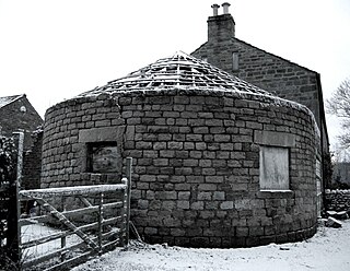
A gin gang, wheelhouse, roundhouse or horse-engine house, is a structure built to enclose a horse engine, usually circular but sometimes square or octagonal, attached to a threshing barn. Most were built in England in the late 18th and early 19th centuries. The threshing barn held a small threshing machine which was connected to the gin gang via wooden gears, drive shafts and drive belt, and was powered by a horse which walked round and round inside the gin gang.

Kilham is a hamlet and civil parish in the English county of Northumberland, located 8.0 miles (12.9 km) west of Wooler, 12.0 miles (19.3 km) east of Kelso, 17.0 miles (27.4 km) south west of Berwick-upon-Tweed and 38.9 miles (62.6 km) north west of Morpeth. It lies on the northern edge of the Northumberland National Park in Bowmont Valley Northumberland. The hamlet, which consists of a small group of agricultural dwellings, is overlooked by Kilham Hill and the northern limits of the Cheviot Hills. The parish had a population of 131 in 2001, and includes the hamlets of Howtel and Pawston, along with the former upland township of Coldsmouth and Thompson's Walls. falling to less than 100 at the 2011 Census. Details are now included in the parish of Branxton

Dally Castle is a ruined 13th-century stone motte-and-bailey fortress in Northumberland, and one of the first hall houses in Northumberland. It lies 5 miles (8.0 km) west of Bellingham Castle, and 4 miles (6.4 km) west of Bellingham on the Chirdon Burn, a tributary of the North Tyne. Dally Castle House was built in the 18th century next to the castle. Across the road lies a small flour mill used to grind wheat during the Napoleonic War.
