Bristol, South Dakota

Last updated

Bristol, South Dakota
Bristol South Dakota Mural.jpg
Day County South Dakota Incorporated and Unincorporated areas Bristol Highlighted.svg
Location in Day County and the state of South Dakota
Coordinates: 45°20′48″N97°44′55″W / 45.34667°N 97.74861°W / 45.34667; -97.74861
Country United States
State South Dakota
County Day
Incorporated1921 [1]
Area
[2]
  Total0.53 sq mi (1.38 km2)
  Land0.52 sq mi (1.35 km2)
  Water0.01 sq mi (0.03 km2)
Elevation
[3]
1,788 ft (545 m)
Population
 (2020) [4]
  Total288
  Density551.72/sq mi (213.00/km2)
Time zone UTC-6 (Central (CST))
  Summer (DST) UTC-5 (CDT)
ZIP code
57219
Area code 605
FIPS code 46-07300
GNIS feature ID1267296 [3]
Website http://www.bristolsd.com/

Bristol is a city located in western Day County, South Dakota, United States. It lies in Section 25 of Bristol Township, on the main line of what is now the BNSF Railway alongside U.S. Route 12. The population was 288 at the 2020 census. [5] `

Contents

Similar to many towns of the area and of the Midwest in general, Bristol came into being as a result of railroad expansion. The railroad, which first came through the area in the 1870s, identified the site which would become Bristol as Station #70. C.P. Prior, a district railroad surveyor and townsite agent, was given credit for naming Bristol in 1881. He named the town after Bristol, England. [6]

Geography

Bristol Post Office Bristol South Dakota Post Office.jpg
Bristol Post Office

According to the United States Census Bureau, the city has a total area of 0.53 square miles (1.37 km2), of which 0.52 square miles (1.35 km2) is land and 0.01 square miles (0.03 km2) is water. [7]

Demographics

Historical population
CensusPop.Note
1890 199
1900 28241.7%
1910 44457.4%
1920 54522.7%
1930 68826.2%
1940 675−1.9%
1950 647−4.1%
1960 562−13.1%
1970 470−16.4%
1980 445−5.3%
1990 419−5.8%
2000 377−10.0%
2010 341−9.5%
2020 288−15.5%
U.S. Decennial Census [8] [4]

2010 census

As of the census [9] of 2010, there were 341 people, 150 households, and 78 families residing in the city. The population density was 655.8 inhabitants per square mile (253.2/km2). There were 176 housing units at an average density of 338.5 per square mile (130.7/km2). The racial makeup of the city was 98.2% White, 0.3% from other races, and 1.5% from two or more races. Hispanic or Latino of any race were 1.5% of the population.

There were 150 households, of which 18.7% had children under the age of 18 living with them, 44.7% were married couples living together, 3.3% had a female householder with no husband present, 4.0% had a male householder with no wife present, and 48.0% were non-families. 42.7% of all households were made up of individuals, and 21.3% had someone living alone who was 65 years of age or older. The average household size was 1.95 and the average family size was 2.65.

The median age in the city was 52.3 years. 15.2% of residents were under the age of 18; 5.9% were between the ages of 18 and 24; 18.8% were from 25 to 44; 23.8% were from 45 to 64; and 36.4% were 65 years of age or older. The gender makeup of the city was 48.1% male and 51.9% female.

2000 census

As of the census of 2000, there were 377 people, 165 households, and 88 families residing in the city. The population density was 718.0 inhabitants per square mile (277.2/km2). There were 186 housing units at an average density of 354.2 per square mile (136.8/km2). The racial makeup of the city was 100.00% White.

There were 165 households, out of which 18.8% had children under the age of 18 living with them, 47.3% were married couples living together, 4.8% had a female householder with no husband present, and 46.1% were non-families. 40.6% of all households were made up of individuals, and 27.3% had someone living alone who was 65 years of age or older. The average household size was 2.01 and the average family size was 2.71.

In the city, the population was spread out, with 18.0% under the age of 18, 6.6% from 18 to 24, 18.0% from 25 to 44, 17.5% from 45 to 64, and 39.8% who were 65 years of age or older. The median age was 54 years. For every 100 females, there were 83.0 males. For every 100 females age 18 and over, there were 82.8 males.

The median income for a household in the city was $32,031, and the median income for a family was $39,375. Males had a median income of $30,208 versus $17,500 for females. The per capita income for the city was $19,006. About 8.7% of families and 6.4% of the population were below the poverty line, including 7.9% of those under age 18 and 7.8% of those age 65 or over.

Notable person

See also

Related Research Articles

<span class="mw-page-title-main">Dakota, Minnesota</span> City in Minnesota, United States

Dakota is a city in Winona County, Minnesota, United States. The population was 295 at the 2020 census.

<span class="mw-page-title-main">White, South Dakota</span> City in South Dakota, United States

White is a city in Brookings County, South Dakota, United States. The population was 537 at the 2020 census.

<span class="mw-page-title-main">Herreid, South Dakota</span> City in South Dakota, United States

Herreid is a city in Campbell County, South Dakota, United States. The population was 416 at the 2020 census.

<span class="mw-page-title-main">Lake Andes, South Dakota</span> City in South Dakota, United States

Lake Andes is a city in, and the county seat of, Charles Mix County, South Dakota, United States. The population was 710 at the 2020 census.

<span class="mw-page-title-main">Wagner, South Dakota</span> City in South Dakota, United States

Wagner is a city in Charles Mix County, South Dakota, United States. The population was 1,490 at the 2020 census. The city is served by Wagner Municipal Airport as well as YST Transit buses.

<span class="mw-page-title-main">Clear Lake, South Dakota</span> City in South Dakota, United States

Clear Lake is a city in and the county seat of Deuel County, South Dakota, United States. The population was 1,218 at the 2020 census.

<span class="mw-page-title-main">Faulkton, South Dakota</span> City in South Dakota, United States

Faulkton is a city in and county seat of Faulk County, South Dakota, United States. The population was 826 at the 2020 census. The city's nickname is "The Carousel City".

<span class="mw-page-title-main">Milbank, South Dakota</span> City in South Dakota, United States

Milbank is a city in Grant County, South Dakota, United States, located along the South Fork of the Whetstone River. The population was 3,544 at the 2020 census. It is the county seat of Grant County. Milbank is the birthplace of American Legion Baseball. The program was created in Milbank in 1925 and is now enjoyed by high school aged youth on more than five thousand teams in all fifty states.

<span class="mw-page-title-main">Burke, South Dakota</span> City in South Dakota, United States

Burke is a city in and county seat of Gregory County, South Dakota, United States. The population was 575 at the 2020 census.

<span class="mw-page-title-main">Alexandria, South Dakota</span> City in South Dakota, United States

Alexandria is a city in central Hanson County, South Dakota, United States. The population was 649 at the 2020 census. It is the county seat of Hanson County.

<span class="mw-page-title-main">Menno, South Dakota</span> City in South Dakota, United States

Menno is a city in Hutchinson County, South Dakota, United States. The population was 614 at the 2020 census.

<span class="mw-page-title-main">Tripp, South Dakota</span> City in South Dakota, United States

Tripp is a city in Hutchinson County, South Dakota, United States. The population was 575 in the 2020 census.

<span class="mw-page-title-main">Central City, South Dakota</span> City in South Dakota, United States

Central City is a city in Lawrence County, South Dakota, United States. The population was 93 at the 2020 census.

<span class="mw-page-title-main">Lennox, South Dakota</span> City in South Dakota, United States

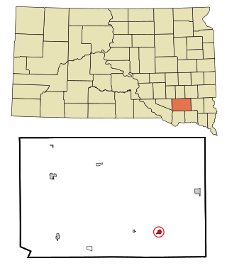
Lennox is a city in Lincoln County, South Dakota, United States, located 20 miles (32 km) southwest of Sioux Falls. The population was 2,423 at the 2020 census.

<span class="mw-page-title-main">Veblen, South Dakota</span> City in South Dakota, United States

Veblen is a city in Marshall County, South Dakota, United States. The population was 317 at the 2020 census.

<span class="mw-page-title-main">Leola, South Dakota</span> City in South Dakota, United States

Leola is a small city in, and the county seat of, McPherson County, South Dakota, United States. It was founded on May 1, 1884, and named for Leola Haynes, daughter of one of the town's founders. The population was 434 as of the 2020 census.

<span class="mw-page-title-main">Crooks, South Dakota</span> City in South Dakota, United States

Crooks is a city in Minnehaha County, South Dakota, United States and is a suburb of Sioux Falls. The population was 1,362 at the 2020 census. Crooks was named New Hope until 1904. The town's present name honors W. A. Crooks, a local politician.

<span class="mw-page-title-main">Claire City, South Dakota</span> Town in South Dakota, United States

Claire City is a town in Roberts County, South Dakota, United States. The population was 82 at the 2020 census.

<span class="mw-page-title-main">Colome, South Dakota</span> City in South Dakota, United States

Colome is a city in Tripp County, South Dakota, United States. The population was 331 as of the 2020 census.

<span class="mw-page-title-main">Alcester, South Dakota</span> City in South Dakota, United States

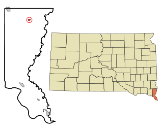
Alcester is a city in northern Union County, South Dakota, United States. It is part of the Sioux City, IA–NE–SD Metropolitan Statistical Area. The population was 820 at the 2020 census.

References

  1. "SD Towns" (PDF). South Dakota State Historical Society. Archived from the original (PDF) on February 10, 2010. Retrieved February 11, 2010.
  2. "ArcGIS REST Services Directory". United States Census Bureau. Retrieved October 15, 2022.
  3. 1 2 U.S. Geological Survey Geographic Names Information System: Bristol, South Dakota
  4. 1 2 "Census Population API". United States Census Bureau. Retrieved October 15, 2022.
  5. "U.S. Census Bureau: Bristol city, South Dakota". www.census.gov. United States Census Bureau. Retrieved March 22, 2022.
  6. Federal Writers' Project (1940). South Dakota place-names, v.1-3. University of South Dakota. p. 28.
  7. "US Gazetteer files 2010". United States Census Bureau. Archived from the original on January 25, 2012. Retrieved June 21, 2012.
  8. United States Census Bureau. "Census of Population and Housing" . Retrieved July 20, 2014.
  9. "U.S. Census website". United States Census Bureau . Retrieved June 21, 2012.