The Stewart Gold Rush
| | This section is empty. You can help by adding to it. (July 2010) |
British Columbia gold rushes were important episodes in the history and settlement of European, Canadian and Chinese peoples in western Canada.
The presence of gold in what is now British Columbia is spoken of in many old legends that, in part, led to its discovery. The Strait of Anian, claimed to have been sailed by Juan de Fuca for whom today's Strait of Juan de Fuca is named, was described as passing through a land (Anian) "rich in gold, silver, pearls and fur". Bergi (meaning "mountains"), another legendary land near Anian, was also said to be rich in gold as well. Speculative maps of northwestern North America published before the area was mapped placed the legendary golden cities of Quivira and Cibola in the far inland northwest.[ citation needed ] No Spanish exploration parties in search of El Dorado, "the golden one" a reference to the legendary king of a lost golden city, are known to have ever reached British Columbia, although archaeological remains point to a brief Spanish presence in the Okanagan and Similkameen regions of the province's Southern Interior.[ citation needed ] The Muchalaht, the Nuu-chah-nulth group in the area of the community of Gold River, on Vancouver Island, which is a community at the end of a fjord that drains the west coast of Vancouver Island, tell a story of Spanish arriving then burning the valley searching for gold. Prospectors searching the valley have found old crude dug adits on the pass of the White River Valley and the Gold River Valley.[ citation needed ]
Gold was first formally discovered by non-indigenous people at Gold Harbour on the west coast of Moresby Island in Haida Gwaii, near the Haida village of Tasu on Mitchell Inlet, an arm of Gold Harbour (which is part of Tasu Sound). A brief gold rush - the Queen Charlottes Gold Rush - ensued in the following year, leading to the declaration of the Colony of the Queen Charlotte Islands to prevent the archipelago from being overrun by Americans and so claimed by the United States. The extent of the ore body proved superficial, and there are various stories of American prospecting parties harassed by the Haida people, who were still very numerous and powerful. In later times, Gold Harbour and Mitchell Inlet became the location of a modern mining operation, also called Tasoo or Tasu, but for iron rather than gold. In 1969, a local logger, Efrem Specogna and his brother-in-law, John Trinco made the initial gold discovery of the Specogna (Babe) Gold deposit west of Port Clements on Graham Island. By 1979, a 2 million ounce gold deposit was defined by exploratory drilling by major mining companies, Cominco, Kennco Explorations (a subsidiary of Kennecott) and Quintana Minerals. A junior exploration company continued drilling the project and a gold rush ensued from 1979-1981. The Specogna gold deposit remains an unmined deposit with over 3 million ounces of gold and is categorized as an epithermal type gold deposit. [1]
Gold discoveries are not reported in the journals of the early fur traders, and it became policy on the part of the fur companies to not advertise the presence of gold as the protection of the fur trade was the main corporate interest of their enterprise. Governor Etolin of Russian America expressly forbade news of gold discoveries as a serious crime against the state. Small quantities of gold were reported by traders in the 1830s and at some posts became current in local trading, though not common or in quantity. but Hudson's Bay Company policy, or the good judgement of the Chief Trader, kept news of such discoveries quiet until a large trove was brought into Fort Kamloops in 1856 by members of the nearby Tranquille tribe of the Secwepemc. When news of the find and a large poke of gold dust brought to James Douglas, Chief Factor of the Columbia Department at Fort Victoria and also Governor of Vancouver Island, decided to ship it to San Francisco for smelting. Some historians have suggested he did so deliberately to spread news of the gold find so as to provoke a gold rush so as to force Britain's hand on the status of the British mainland north of the 49th parallel, which since the Oregon Treaty had remained unincorporated and had remained solely the domain of the fur company and its native clientele. American miners had been appearing more frequently on British soil and Douglas felt he had to take action. [2] [3]
News of the finds in what was then known as New Caledonia hit California at a time of economic depression, when the gold fields were depopulated and many miners were in San Francisco, where the news hit like wildfire and overloaded steamers full of men equipped with not much more than gold pans and the clothes on their back headed north, along with entrepreneurs of all kinds and others seeking to profit not from the mines, but from the miners. Victoria, until then a "sleepy English village" of a few hundred people, was transformed into a tent city of some 30,000 within weeks in the spring of 1858, among them 4000 were Chinese. [4] After initial complaints of a "humbug", because high water levels prevented mining, thousands returned to California, only to be replaced by others as water levels dropped and mining began in earnest. The first major find, and among the largest on the river, was at Hill's Bar about 15 kilometers south of Fort Yale, which had become the epicenter of the gold rush as it was at the head of river navigation and at the foot of the Fraser Canyon and its difficult trails and rich gold-bearing bars. Hill's Bar's first claim, known as the "Boatmen of San Francisco", worked the bar alongside Chief Kowpelst and his people, the Spuzzum tribe of the Nlaka'pamux, whose village was just north of Fort Yale. The mining population, split into thirds about evenly between Americans, Chinese, and a mix of Britons and Europeans who had been in California, many since the California Gold Rush ten years earlier, entered into conflict when two French miners violated a Nlaka'pamux girl near Lytton, then called "the Forks", and their beheaded bodies were seen floating down the river. In the ensuing unrest, known as the Fraser Canyon War, most of the mining population fled the Canyon for Spuzzum and Yale, and war parties composed of Americans, Germans, French and others (many who had been mercenaries in Nicaragua, or in service of France in Mexico), forayed up the canyon and made a peace with the Nlaka'pamux, though many were killed on both sides. News of the war had reached Victoria in the meantime and Governor Douglas was forced to take action to enforce British authority and sovereignty on the mainland and set out by steamer with Royal Marines and the newly arrived first contingent of Royal Engineers for the gold fields. En route, the party stopped at Fort Langley, then still located at Derby, where Douglas declared the Colony of British Columbia and was sworn in as its first Governor, on August 1, 1858. Proceeding without much incident to Yale, where news of the governor's journey upriver had travelled in advance, the Governor and his troops were greeted by the war parties or "Companies" that had engaged in the war, flying the British flag and greeting the Governor with a formal welcome. Admonishing them that the colony had been established and the Queen's Law would prevail, the governor appointed officials who would later lead to a series of events known as McGowan's War over the course of the next winter. Also while at Yale, Douglas decreed the creation of subscriptions by which parties of men could pay for the right to construct a new route to the "Upper Fraser" via the Lakes Route, as a way around the dangers of the canyon trail and continued fears about the Nlaka'pamux. the "Upper Fraser" was the area of Lillooet and Fountain and several thousand miners had arrived in that region via overland routes through Oregon and Washington Territory, despite an injunction from Douglas that all access to the goldfields would be through Victoria only. Those who came by those routes, the busiest but war-ridden Okanagan Trail, also spread farther afield in the Interior, leading to gold discoveries further and further afield and a string of small and large gold rushes including what would become the largest and most famous, the Cariboo Gold Rush. Not for nothing that among the most common sobriquet used at the time for the new Mainland Colony was "the Gold Colonies".
By 1860, there were gold discoveries in the middle basin of the Quesnel River around Keithley Creek and Quesnel Forks, just below and west of Quesnel Lake. Exploration of the region intensified as news of the discoveries got out, and because of the distances and times involved in communications and travel in those times, moreover because of the remoteness of the country, the Cariboo Rush did not begin in earnest until 1862 after the discovery of Williams Creek in 1861 and the relocation of the focus of the rush to the creek valleys in the northern Cariboo Plateau forming the headwaters of the Willow River and the north slope of the basin of the Quesnel. The rush, though initially discovered by American-based parties, became notably Canadian, Maritimer and British in character, with those who became established in the Cariboo among the vanguard of the movement to join Canada as the 1860s progressed. Many Americans returned to the United States at the opening of the Civil War. Others went on to the Fort Colvile Gold Rush, Idaho Gold Rush, and Colorado Gold Rush. Some went elsewhere in the Intermontane West, including other parts of British Columbia, in addition to those who had come and gone during the advent and wane of the Cariboo rush. To preserve British authority and retain control over the traffic of gold out of the region, the Governor commissioned the building of the Cariboo Road, a.k.a. the Queen's Highway, and a route from Lillooet and also established the Gold Escort, although that government agency never proved viable and private expressmen dominated the shipment of goods and mail into the gold fields, and gold out of it (see Francis Jones Barnard and B.X. Express). Among other events associated with the Cariboo Gold Rush was the Chilcotin War of 1864, provoked by an attempt to build a wagon road from Bute Inlet to Cariboo via the Homathko River. In addition to the gold rush's capital and destination of the Cariboo Road Barkerville, dozens of small towns and mining camps sprang up across the rainy, swampy hills of the Cariboo, some such as Bullion and Antler Creek attaining mining fame in their own right. The Cariboo gold fields have remained active to this day, and have also yielded other boomtowns, such as Wells, a one-time company town of 3,000 in the 1920s just a few kilometres west of Barkerville, which today is a museum town, and one of the larger deep-rock mines in the Cariboo mining district. The city of Quesnel, remained important after the wane of the rush as the jumping-off point for other goldfields discovered yet farther and farther north in the Omineca and Peace River Country to the north of Fort George (today's city of Prince George), then only a small fur post and Indian reserve.
| | This section is empty. You can help by adding to it. (July 2010) |
| | This section is empty. You can help by adding to it. (July 2010) |

The Cariboo is an intermontane region of British Columbia, Canada, centered on a plateau stretching from Fraser Canyon to the Cariboo Mountains. The name is a reference to the caribou that were once abundant in the region.
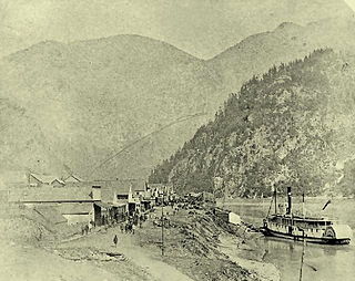
Yale is an unincorporated town in the Canadian province of British Columbia, which grew in importance during the gold rush era.
Spuzzum is an unincorporated settlement in British Columbia, Canada. Because it is on the Trans-Canada Highway, approximately 50 kilometres (31 mi) north of the community of Hope, it is often referred to as being "beyond Hope".

Sir James Douglas was a Canadian fur trader and politician who became the first Governor of the Colony of British Columbia. He is often credited as "The Father of British Columbia." He was instrumental to the resettlement of 35 African-Americans fleeing a life of racial persecution in San Francisco who arrived in the province aboard the steampship Commodore in what later became known as the Pioneer Committee. In 1863, Douglas was knighted by Queen Victoria for his services to the Crown.

The Cariboo Road was a project initiated in 1860 by the Governor of the Colony of British Columbia, James Douglas. It involved a feat of engineering stretching from Fort Yale to Barkerville, B.C. through extremely hazardous canyon territory in the Interior of British Columbia.

The Cariboo Gold Rush was a gold rush in the Colony of British Columbia, which later joined the Canadian province of British Columbia. The first gold discovery was made at Hills Bar in 1858, followed by more strikes in 1859 on the Horsefly River, and on Keithley Creek and Antler Creek in 1860. The actual rush did not begin until 1861, when these discoveries were widely publicized. By 1865, following the strikes along Williams Creek, the rush was in full swing.

The Fraser Canyon Gold Rush, began in 1858 after gold was discovered on the Thompson River in British Columbia at its confluence with the Nicoamen River a few miles upstream from the Thompson's confluence with the Fraser River at present-day Lytton. The rush overtook the region around the discovery, and was centered on the Fraser Canyon from around Hope and Yale to Pavilion and Fountain, just north of Lillooet.

The Douglas Road, a.k.a. the Lillooet Trail, Harrison Trail or Lakes Route, was a goldrush-era transportation route from the British Columbia Coast to the Interior. Over 30,000 men are reckoned to have travelled the route in, although by the end of the 1860s it was virtually abandoned due to the construction of the Cariboo Wagon Road, which bypassed the region.

Alexandra Bridge Provincial Park is a provincial park located in the Fraser Canyon of British Columbia, Canada. It was established on March 26, 1984 to preserve a historically significant suspension bridge spanning the Fraser River. The extant bridge was built in 1926 on foundation piers from 1863.

The Colony of British Columbia was a crown colony in British North America from 1858 until 1866 that was founded by Richard Clement Moody, who was selected to 'found a second England on the shores of the Pacific', who was Chief Commissioner of Lands and Works for British Columbia and the first Lieutenant-Governor of British Columbia. Prior to the arrival of Moody's Royal Engineers, Columbia Detachment, the Colony's supreme authority was its Governor James Douglas, who was the Governor of the neighbouring colony of Vancouver Island.
The Fraser Canyon War, also known as the Canyon War or the Fraser River War, was an incident between the Nlaka'pamux people and white miners in the newly declared Colony of British Columbia, which later became part of Canada, in 1858. It occurred during the Fraser Canyon Gold Rush, which brought many white settlers to the Fraser Canyon area. Largely ignored by Canadian historians, it was one of the seminal events of the founding of the colony. Although it ended relatively peacefully, it was a major test of the new administration's control over the goldfields, which were distant and difficult to access from the centre of colonial authority at Victoria in the Colony of Vancouver Island.
Soda Creek is a rural subdivision 38 km north of Williams Lake in British Columbia, Canada. Located on the east bank of the Fraser River, Soda Creek was originally the home of the Xat'sull First Nation. Soda Creek Indian Reserve No. 1 is located on the left (E) bank of the Fraser River, one mile south of the Soda Creek BCR (CN) station, 431.10 ha. 52°19′00″N122°16′00″W
Nicola, also Nkwala or N'kwala, was an important First Nations political figure in the fur trade era of the British Columbia Interior as well as into the colonial period (1858–1871). He was grand chief of the Okanagan people and chief of the Nicola Valley peoples, an alliance of Nlaka'pamux and Okanagans and the surviving Nicola Athapaskans, and also of the Kamloops Band of the Shuswap people.
Spuzzum First Nation is a Nlaka'pamux First Nations government located near Spuzzum, British Columbia. It is a member of the Fraser Canyon Indian Administration, one of three tribal councils of the Nlaka'pamux people. Other members of the Fraser Canyon Indian Administration are the Kanaka Bar, Skuppah and Nicomen First Nations.
The Rock Creek Gold Rush was a gold rush in the Boundary Country region of the Colony of British Columbia. The rush was touched off in 1859 when two US soldiers were driven across the border to escape pursuing Indians and chanced on gold only three miles into British territory, on the banks of the Kettle River where it is met by Rock Creek, and both streams turn east to where in times since developed the city of Grand Forks. The first claim was filed by an Adam Beam in 1860, and the rush was on, composed mostly of Americans and some Chinese, all of whom had come overland from other workings, either at Colville or Oregon or all the way from California.
The Big Bend Gold Rush was a gold rush in the Big Bend Country of the Colony of British Columbia in the mid-1860s.
The Old Cariboo Road is a reference to the original wagon road to the Cariboo gold fields in what is now the Canadian province of British Columbia. It should not be confused with the Cariboo Road, which was built slightly later and used a different route.

The Stikine Country, also referred to as the Stikine District or simply "the Stikine", is one of the historical geographic regions of the Canadian province of British Columbia, located inland from the central Alaska Panhandle and comprising the basin of the Stikine River and its tributaries. The term Stikine–Iskut is also fairly common to describe the area, and references the Iskut River, the Stikine's largest tributary and describable as its south fork.
The Omineca Gold Rush was a gold rush in British Columbia, Canada in the Omineca region of the Northern Interior of the province. Gold was first discovered there in 1861, but the rush didn't begin until late in 1869 with the discovery at Vital Creek. There were several routes to the goldfields: two were from Fort St. James, one of which was a water route through the Stuart and Tachie Rivers to Trembleur Lake to Takla Lake and the other was overland, called the Baldy Mountain route. A third route came in overland from Hazelton on the Skeena River and a fourth route used the Fraser River and crossed over the Giscome Portage to Summit Lake, through McLeod Lake, and up the Finlay River to the Omineca River.

Thompson Country, also referred to as The Thompson and sometimes as the Thompson Valley and historically known as the Couteau Country or Couteau District, is a historic geographic region of the Southern Interior of British Columbia, more or less defined by the basin of the Thompson River. This is a tributary of the Fraser; the major city in the area is Kamloops.