
Richmondtown is a neighborhood in the Mid-Island section of Staten Island, New York City. It is bounded by Arthur Kill Road on the northwest, Richmond Road on the north, Amboy Road on the east and southeast, and the United Hebrew and Ocean View cemeteries on the southwest.

New Dorp is a neighborhood on the East Shore of Staten Island, New York City, United States. New Dorp is bounded by Mill Road on the southeast, Tysens Lane on the southwest, Amboy and Richmond Roads on the northwest, and Bancroft Avenue on the northeast. It is adjacent to Oakwood to the southwest, Todt Hill to the northwest, Dongan Hills and Grant City, and Midland Beach and Miller Field to the southeast. New Dorp Beach, bordering to the east, is often listed on maps as a separate neighborhood from Mill Road to the shore of Lower New York Bay, but is generally considered to be a part of New Dorp.

Nathaniel Lord Britton was an American botanist and taxonomist who co-founded the New York Botanical Garden in the Bronx, New York.

Historic Richmond Town is an authentic town and farm museum complex in the neighborhood of Richmondtown, Staten Island, in New York City. It is located near the geographical center of the island, at the junction of Richmond Road and Arthur Kill Road. Staten Island Historical Society and Historic Richmond Town are two different names for the same organization, reflecting its long history and evolution.

The Moravian Cemetery is a cemetery in the New Dorp neighborhood of Staten Island, New York City. Located at 2205 Richmond Road, the Moravian is the largest and oldest active cemetery on Staten Island, having opened in 1740. The cemetery encompasses 113 acres and is the property of the local Moravian Church congregation of Staten Island. To the cemetery's southwest is High Rock Park, one of the constituent parks of the Staten Island Greenbelt.

The term East Shore is frequently applied to a series of neighborhoods along the Lower New York Bay and the Raritan Bay and within New York City's borough of Staten Island.

The term North Shore is frequently applied to a series of neighborhoods within the New York City borough of Staten Island.
Mid-Island is frequently applied to a series of neighborhoods within the New York City borough of Staten Island.

Oakwood is a neighborhood located in east central Staten Island, New York City, near the South Shore. It is bordered by Tysens Lane (north); the Atlantic Ocean (east); Great Kills Park (south); Kensico Street, and Clarke Avenue (west).

Dongan Hills is a neighborhood located within the New York City borough of Staten Island. It is on the Island's East Shore. Dongan Hills is bounded by Laconia Avenue on the southeast, Jefferson Avenue on the southwest, Richmond Road on the northwest, and Old Town Road to the north. It is adjacent to New Dorp and Grant City to the southwest, Todt Hill to the northwest, Old Town/Concord to the northeast, and South Beach and Midland Beach to the southeast.
Lighthouse Hill is the name of a hill, and the neighborhood situated thereon, in the New York City borough of Staten Island. Lighthouse Hill is situated to the north of Richmondtown, south of Todt Hill, and west of Grant City.
Egbertville is the name of a neighborhood located immediately inland from, but classifiable within, the East Shore of the borough of Staten Island in New York City. Named after a family that owned a farm there in the 18th century, Egbertville was known for a time as Morgan's Corner, from 1838; soon after this, many Irish families arrived in the area, leading to its being referred to by such names as Tipperary Corners, New Dublin, and Young Ireland.
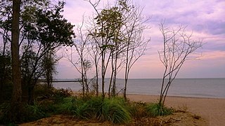
New Dorp Beach is along the shore of the neighborhood of New Dorp, on Staten Island, one of the five boroughs of New York City. It is between Midland Beach and Oakwood Beach.
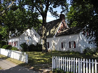
The Billiou–Stillwell–Perine House is a Dutch Colonial structure and the oldest standing building on Staten Island, New York.

New Dorp is a Staten Island Railway station in the neighborhood of New Dorp, Staten Island, New York.

The Abraham Manee House, also known as the Manee-Seguine Homestead, is a three-part Colonial Dutch dwelling on Staten Island in New York. It was designated a New York City landmark in 1984. Located on Purdy Place adjacent to Lemon Creek, on the South Shore of Staten Island, the oldest section is a one-room structure built by Paulus Regrenier in 1670, a French Huguenot fleeing religious persecution in Europe. The building is similar to the Billiou-Stillwell-Perine House in Old Town.

Staten Island Museum is Staten Island’s oldest cultural institution, and the only remaining general interest museum in New York City.

Southfield was a Town in Richmond County, New York. It was located in the southeastern part of Staten Island, along Lower New York Bay prior to the incorporation of Staten Island into New York City in 1898, bounded on the west roughly by Richmond Road, Giffords Lane, Amboy Road, and Arden Avenue.
This is a timeline of Staten Island.

The Old Britton House was a house located on the western side of Amboy Road almost directly opposite of Tysens Lane in the New Dorp Beach section of Staten Island, New York. At one time, it was one of the oldest structures on Staten Island. Built between 1650 and 1680 by a Huguenot refugee, the house was the site of an Indian massacre, the headquarters for a Hessian commander during the American Revolutionary War, a smallpox hospital and a colonial courthouse. It was demolished in 1896 and the stones that formed the walls were crushed up into macadam.


