
Brixton is an area of South London, part of the London Borough of Lambeth, England. The area is identified in the London Plan as one of 35 major centres in Greater London. Brixton experienced a rapid rise in population during the 19th century as communications with central London improved.

Kennington is a district in south London, England. It is mainly within the London Borough of Lambeth, running along the boundary with the London Borough of Southwark, a boundary which can be discerned from the early medieval period between the Lambeth and St George's parishes of those boroughs respectively. It is located 1.4 miles (2.3 km) south of Charing Cross in Inner London and is identified as a local centre in the London Plan. It was a royal manor in the parish of St Mary, Lambeth in the county of Surrey and was the administrative centre of the parish from 1853. Proximity to central London was key to the development of the area as a residential suburb and it was incorporated into the metropolitan area of London in 1855.

Stockwell is a district located in South London, part of the London Borough of Lambeth, England. It is situated 2.4 miles (3.9 km) south of Charing Cross.

Lambeth is a London borough in South London, England, which forms part of Inner London. Its name was recorded in 1062 as Lambehitha and in 1255 as Lambeth. The geographical centre of London is at Frazier Street near Lambeth North tube station, though nearby Charing Cross on the other side of the Thames in the City of Westminster is traditionally considered the centre of London.
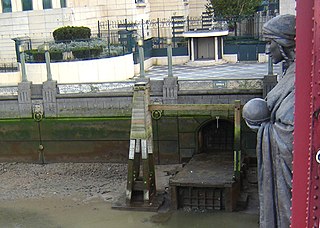
The River Effra is a former set of streams in south London, England, culverted and used mainly for storm sewerage. It had been a tributary of the Thames. Its catchment waters, where not drained to aquifer soakaways and surface water drains, have been incorporated into 1850s-built combined sewer sectors, devised by Sir Joseph Bazalgette. One drains Peckham, the other Brixton, then intended to flow towards Peckham. These generally flow east to be treated at Crossness.
Lambeth was a civil parish and metropolitan borough in south London, England. It was an ancient parish in the county of Surrey. The parish was included in the area of responsibility of the Metropolitan Board of Works in 1855 and became part of the County of London in 1889. The parish of Lambeth became a metropolitan borough in 1900, following the London Government Act 1899, with the parish vestry replaced by a borough council.

Kennington Road is a long straight road, approximately a mile in length, in the London Borough of Lambeth in London, England, running south from Westminster Bridge Road to Kennington Park Road.

London Buses route 3 is a Transport for London contracted bus route in London, England. Running between Crystal Palace and Victoria bus stations, it is operated by Transport UK London Bus.

Cross River Tram was a Transport for London (TfL) proposal for a 10-mile (16 km) tram system in London. It was planned to run on a north–south route from Camden Town in the north, via King's Cross, to Peckham and Brixton in the south.

Brixton was a parliamentary constituency centred on the Brixton district of South London. It returned one Member of Parliament (MP) to the House of Commons of the Parliament of the United Kingdom, elected by the first-past-the-post system.

The A202 is a primary A road in London. It runs from New Cross Gate to London Victoria station. A section of the route forms a part of the London Inner Ring Road between Vauxhall and Victoria, known as Vauxhall Bridge Road.

Vassall ward was an administrative division of the London Borough of Lambeth, United Kingdom, from 1965 to 2022. It was located in the north of borough bordering Southwark, in the SW9 and SE5 postcode area. The ward was named after Henry Vassall-Fox, 3rd Baron Holland who was responsible for the first building development in the area in the 1820s.
Sidney R. J. Smith (1858–1913) was a Late Victorian English architect, best known for the work he undertook in the 1880s and 1890s for the philanthropist Henry Tate including the original Tate Gallery at Millbank.
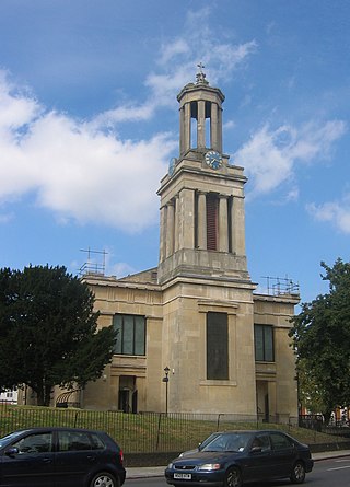
St Matthew's Church is a Church of England church in the London Borough of Lambeth. It is a Grade II* listed building which occupies a prominent position at the junction of Brixton Road, Brixton Hill and Effra Road. The church was constructed following the Church Building Act 1818 and was consecrated in 1824.
Raleigh Hall is a building in Windrush Square, Brixton. It is now home to the Black Cultural Archives, after being derelict for many years.

Lambeth Town Hall, also known as Brixton Town Hall, is a municipal building at the corner of Brixton Hill and Acre Lane, Brixton, London. The town hall, which is the headquarters of Lambeth London Borough Council, is a Grade II listed building.

Windrush Square is an open public space in the centre of Brixton, South London, occupying an area in front of the Brixton Tate Library. After changing its name to Tate Gardens, it was again retitled and given its current moniker in 1998. The square was renamed to recognise the important contribution of the African Caribbean community to the area, marking the 50th anniversary of the arrival of the HMT Empire Windrush. It was the Windrush that in 1948 brought to the United Kingdom from Jamaica the largest group thus far of post-war West Indian migrants, 236 of whom had no abode on arrival and were temporarily housed in the deep-level air raid shelter in Clapham Common. Some 1.7 mile away, at the western end of Coldharbour Lane in Brixton, was the nearest employment exchange to the shelter. Many of these migrants eventually found accommodation in the area.
Rush Common is a linear protected open space and former common land in Brixton, London, England. It was enclosed in 1806 with the sections fronting public highways protected from development as proscribed land. Most of this land now forms private gardens, forecourts and portions of Brixton Hill are a public park managed by Lambeth Council. There have been several encroachments on the protected land, including small sections of St Matthew's Estate and part of St Matthew's Church. Lambeth Council holds enforcement powers to prevent the building of permanent structures on the proscribed land.
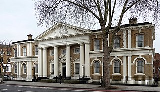
The Old Town Hall is a former municipal building in Kennington Road, Kennington, London, England. The town hall, which was briefly the headquarters of the Metropolitan Borough of Lambeth, is a Grade II listed building.

