Related Research Articles

Beaufort County is a county in the U.S. state of South Carolina. As of the 2010 census, its population was 162,233. Its county seat is Beaufort.

Beaufort is a city in and the county seat of Beaufort County, South Carolina, United States. Chartered in 1711, it is the second-oldest city in South Carolina, behind Charleston. The city's population was 12,361 in the 2010 census. It is a primary city within the Hilton Head Island-Bluffton-Beaufort, SC Metropolitan Statistical Area.

Port Royal is a town on Port Royal Island in Beaufort County, South Carolina, United States. Largely because of annexation of surrounding areas, the population of Port Royal rose from 3,950 in 2000 to 10,678 in 2010, a 170% increase. As defined by the U.S. Census Bureau, Port Royal is included within the Hilton Head Island-Bluffton-Beaufort, SC Metropolitan Statistical Area. Port Royal is home to Marine Corps Recruit Depot Parris Island and Naval Hospital Beaufort.

Hardeeville is a city in Jasper and Beaufort counties in the U.S. state of South Carolina. The population was 2,952 as of the 2010 census and was estimated to be 6,515 in 2018. Hardeeville is included within the Hilton Head Island-Bluffton-Beaufort, SC Metropolitan Statistical Area.

The University of South Carolina Beaufort is a public university with three campuses located in the Lowcountry region of South Carolina. It is part of the University of South Carolina System and enrolls about 1,900 students. The main campus is in Bluffton, offering over 20 programs of study. The institution's campus in Beaufort houses the school's honor programs and the Department of Visual Arts & Design. The campus in Hilton Head Island is home to the school's program for hospitality management.

The Lowcountry is a geographic and cultural region along South Carolina's coast, including the Sea Islands. Once known for its slave-based agricultural wealth in rice and indigo, crops that flourished in the hot subtropical climate, the Lowcountry today is known for its historic cities and communities, natural environment, cultural heritage, and tourism industry.
The Treaty of Beaufort, also called the Beaufort Convention, is the treaty that originally set the all-river boundary between the U.S. states of Georgia and South Carolina. It was named for Beaufort, South Carolina, where it was signed in 1787.

W30CV-D, virtual and UHF digital channel 30, branded on-air as WHHI-TV, is a low-powered, Class A independent television station licensed to Hilton Head Island, South Carolina. The station is carried on area cable systems operated by Hargray and Time Warner Cable.
Port Royal Sound is a coastal sound, or inlet of the Atlantic Ocean, located in the Sea Islands region, in Beaufort County in the U.S. state of South Carolina. It is the estuary of several rivers, the largest of which is the Broad River.
The Beaufort County School District educates nearly 22,000 students in Beaufort County, South Carolina, United States. It is the second fastest-growing county in the state.

The Battle of Beaufort, also known as the Battle of Port Royal Island, was fought on February 3, 1779, near Beaufort, South Carolina, during the American Revolutionary War. The battle took place not long after British forces consolidated control around Savannah, Georgia, which they had captured in December 1778.
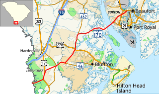
South Carolina Highway 170 (SC 170) is a 49.010-mile (78.874 km) state highway, connecting northern Beaufort County with southern portions of Beaufort and Jasper counties. Due to increased population growth in both areas, the majority of the road is four lanes wide, with certain areas retaining the original two-lane configuration.

Ladys Island is a predominantly residential Sea Island located in Beaufort County, South Carolina. Small portions of the island are within the City of Beaufort, while the majority of the island remains unincorporated. The South Carolina Highway 802, also known locally as Sams Point Road, serves as the principal highway for Ladys Island and provides the only access to Coosaw Island.
The Broad River Bridge is a 1.7-mile-long (2.7 km) highway bridge that spans the Broad River in Beaufort County, South Carolina. Originally built as a two-lane drawbridge, growth pressures and safety concerns demanded that a larger and taller fixed-span bridge be built. The current four-lane wide structure was completed in 2004 and carries South Carolina Highway 170 as it connects northern and southern sections of Beaufort County. Portions of the previous bridge were purchased by Beaufort County and are now used as a fishing dock. In 2009, landscaping was added to the eastern approaches to the bridge.

The Beaufort-Jasper Water and Sewer Authority is a public water system and non-profit corporation which handles water and wastewater operations for many areas in Beaufort and Jasper counties in the Lowcountry region of South Carolina. The Authority was created under the provisions of Act 784 by the South Carolina General Assembly in 1954 to provide services to Beaufort County. In 1969, its powers were expanded to include wastewater facility construction and services. In 1983, the authority merged with the Jasper County Water and Sewer Authority and thus adopting the BJWSA moniker.
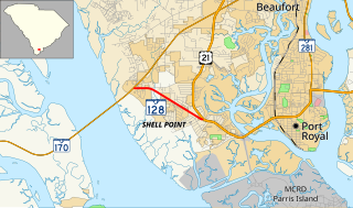
South Carolina Highway 128 (SC 128), is a 2.110-mile (3.396 km) state highway located entirely within Beaufort County, South Carolina. Also known locally as Savannah Highway, SC 128 serves as a principal arterial for the unincorporated Shell Point as well as providing a southern route serving Port Royal, Marine Corps Recruit Depot Parris Island, and the Sea Islands east of Beaufort.

Okatie is an unincorporated suburban community west of Hilton Head Island, located in Beaufort and Jasper counties, in the Lowcountry of South Carolina. Okatie takes its name from the nearby Okatee River, an estuary of the Port Royal Sound. The headquarters of the Beaufort-Jasper Water and Sewer Authority are located in Okatie, as are the Beaufort-Jasper Academy for Career Excellence and John Paul II Catholic High School.
Pocotaligo is an unincorporated community located in northeastern Jasper County, South Carolina, United States, close to the border of Beaufort County. The community takes its name from the Pocotaligo River, a small tidal creek that separates Jasper and Beaufort counties. Although historically significant, Pocotaligo today primarily serves as a junction point between U.S. Highway 17, U.S. Highway 17 Alternate and U.S. Highway 21. These roads lead to Interstate 95 at Point South and Yemassee, which have over time eclipsed Pocotaligo in population and importance. Very few people live in the community today.

The Hilton Head Island-Bluffton-Beaufort Metropolitan Statistical Area, as defined by the United States Census Bureau, is an area consisting of the two southernmost counties in the Lowcountry region of South Carolina, centered on the town of Hilton Head Island.
Saint John Paul II Catholic School is a diocesan Roman Catholic school in Okatie, South Carolina, United States. Founded in 2011 and opened in 2013, the school offers grades 7 through 12 for students in Beaufort and Jasper counties. The school is supported through its affiliation with the Diocese of Charleston. It will be the fourth diocesan school to be in operation in South Carolina, joining Bishop England High School in Charleston, Cardinal Newman High School in Columbia and Bishop Baker High School in Myrtle Beach.
References
- ↑ U.S. Geological Survey Geographic Names Information System: Broad River (South Carolina)
- ↑ Columbia University Press. "Broad River". Bartleby.com. Archived from the original on 9 May 2005. Retrieved 2 November 2006.
| Authority control |
|
|---|
| This article related to a river in South Carolina is a stub. You can help Wikipedia by expanding it. |