
Tweed Heads is a coastal town at the mouth of the Tweed River in the Northern Rivers region of the state of New South Wales, Australia. Tweed Heads is the northernmost town in New South Wales, and is located in the Tweed Shire local government area. It is situated 830 km (520 mi) north of Sydney and 103 km (64 mi) south of Brisbane. The town is next to the border with Queensland and is adjacent to its "twin town" of Coolangatta, which is a suburb of the Gold Coast in Queensland.
CSR Limited is a major Australian industrial company, producing building products and having a 25% share in the Tomago aluminium smelter located near Newcastle, New South Wales. It is publicly traded on the Australian Securities Exchange. In 2021, it had over 3,000 employees and reported an after-tax profit of $146 million. The company has a diversified shareholding, with predominantly Australian fund managers and retail owners. The group's corporate headquarters is in North Ryde, Sydney.
Ingham is a rural town and locality in the Shire of Hinchinbrook, Queensland, Australia. It is named after William Bairstow Ingham and is the administrative centre for the Shire of Hinchinbrook.
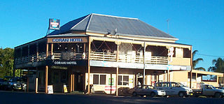
Coraki is a small town that sits on the confluence of the Richmond and Wilsons Rivers in northern New South Wales, Australia in Richmond Valley Shire. At the 2021 census, Coraki had a population of 1,277 people.

Richmond Valley Council (RVC) is a local government area on the Northern Rivers region of north-eastern New South Wales, Australia. RVC services an area of 3,051 square kilometres (1,178 sq mi) and draws its name from the Richmond River, which flows through most of the council area. The area under management is located adjacent to the Bruxner Highway, Pacific Highway, and the North Coast railway line.

Evans Head is a town in Richmond Valley Council of the Northern Rivers region of New South Wales, Australia. At the 2016 census, Evans Head had a population of 2,843 people. It is 726 kilometres north of Sydney, and 11 kilometres east off the Pacific Highway from Woodburn.

Giru is a town and coastal locality in the Shire of Burdekin, Queensland, Australia, situated on the Haughton River, 54 kilometres (34 mi) south-east of Townsville. In the 2016 census, the locality of Giru had a population of 354 people.
The Harwood Sugar Mill is located on Harwood Island on the Clarence River in the Northern Rivers region in north-eastern New South Wales, Australia. It began operations in 1874, and is the oldest sugar cane crushing mill still operating in Australia. Harwood Mill is one of the three sugar mills in NSW with the other mills located at Condong on the Tweed River and Broadwater on the Richmond River.

Woodburn is a small highway town on the banks of the Richmond River in New South Wales, Australia. Until the town was bypassed in September 2020, the busy Pacific Highway passed through the centre of town. Woodburn is 712 km north of the state capital, Sydney, and 34 km south of the regional city of Lismore.

Maclean is a town in Clarence Valley local government area in the Northern Rivers region of New South Wales, Australia. It is on the Clarence River and near the Pacific Highway. At the 2021 census, Maclean had a population of 2,778, total urban area including Townsend and Gulmarrad is more than 8,304. The Maclean, Yamba and Iluka area known as the Lower Clarence had a combined population of 17,533. Its industries are tourism, sugar cane production, farming and river-prawn trawling. Together with Grafton, Maclean is the shared administrative centre for the Clarence Valley Council local government area.

Boambee is a suburb in the city of Coffs Harbour on the Mid North Coast of New South Wales, Australia. Boambee is west of Sawtell on the Pacific Highway. It is divided into two sections: semi-rural Boambee (2450) and the more suburban Boambee East (2452). These suburbs are divided by the Pacific Highway. In 2011, Boambee had a population of 1,545 people, while Boambee East had a population of 5,446 people.

Alstonville is a town in northern New South Wales, Australia, part of the region known as the Northern Rivers. Alstonville is on the Bruxner Highway between the town of Ballina and city of Lismore. The village of Wollongbar is 4 km to the west of Alstonville. Alstonville is the service centre of the area known as the Alstonville Plateau.
Brightwaters is a suburb of the City of Lake Macquarie in New South Wales, Australia on a peninsula east of the town of Morisset on the western shore of Lake Macquarie.

Wardell is a village in the Northern Rivers region of New South Wales, Australia. It is situated on the Richmond River and the Pacific Highway between Broadwater and Ballina. Wardell is approximately 724 km (450 mi) north of Sydney and 200 km (124 mi) south of Brisbane. The boundaries are within the Ballina Shire local government area.

Steiglitz is a rural coastal town and locality in the City of Gold Coast, Queensland, Australia. In the 2016 census the locality of Steiglitz had a population of 705 people.
Richmond is a suburb of Mackay in the Mackay Region, Queensland, Australia. In the 2016 census Richmond had a population of 486 people.

The Old Sugarmill is a heritage-listed former sugar mill and now apartments at Sugar House Road, Canterbury in the City of Canterbury-Bankstown local government area of New South Wales, Australia. It was designed by Woodhouse Danks and built from 1839 to 1841. It is also known as Canterbury Sugar Works, Former Hutton Premises, Australian Sugar Company Mill, Canterbury Sugar House, ASC Sugar Mill Buildings and Australasian Sugar Company. It was added to the New South Wales State Heritage Register on 2 April 1999.
No. 6 Branch is a rural locality in the Cassowary Coast Region, Queensland, Australia. In the 2016 census, No. 6 Branch had a population of 50 people.
Germantown is a rural locality in the Cassowary Coast Region, Queensland, Australia. In the 2021 census, Germantown had a population of 52 people.
Sundown is a rural locality in the Cassowary Coast Region, Queensland, Australia. In the 2021 census, Sundown had a population of 145 people.
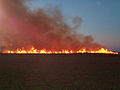 Sugar cane burns before harvesting for the Broadwater mill
 A cane harvester collects cane for the mill
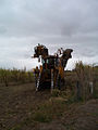 A stationary harvester
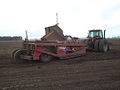 A laser bucket levels a new cane paddock for planting at Tuckurimba, near Broadwater
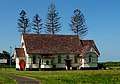 A wooden church in Broadwater


