
A rip tide, or riptide, is a strong offshore current that is caused by the tide pulling water through an inlet along a barrier beach, at a lagoon or inland marina where tide water flows steadily out to sea during ebb tide. It is a strong tidal flow of water within estuaries and other enclosed tidal areas. The riptides become the strongest where the flow is constricted. When there is a falling or ebbing tide, the outflow water is strongly flowing through an inlet toward the sea, especially once stabilised by jetties.

The Bristol Channel is a major inlet in the island of Great Britain, separating South Wales and South West England. It extends from the smaller Severn Estuary of the River Severn to the North Atlantic Ocean. It takes its name from the English city and port of Bristol.

Swansea Bay is a bay on the southern coast of Wales. The River Neath, River Tawe, River Afan, River Kenfig and Clyne River flow into the bay. Swansea Bay and the upper reaches of the Bristol Channel experience a large tidal range. The shipping ports in Swansea Bay are Swansea Docks, Port Talbot Docks and Briton Ferry wharfs.

Carmarthen Bay is an inlet of the South Wales coast, including notable beaches such as Pendine Sands and Cefn Sidan sands. Carmarthen Bay is partially within the Pembrokeshire Coast National Park. The Joint Nature Conservation Committee list Carmarthen Bay and Estuaries as a Special Area of Conservation.

The Thames Estuary is where the River Thames meets the waters of the North Sea, in the south-east of Great Britain.

Oxwich Bay is a bay on the south of the Gower Peninsula, Wales.

The River Loughor is a river in Wales which marks the border between Carmarthenshire and Swansea. The river is sourced from an underground lake at the Black Mountain emerging at the surface from Llygad Llwchwr which translates from the Welsh as "eye of the Loughor". It flows past Ammanford and Hendy in Carmarthenshire and Pontarddulais in Swansea. The river divides Carmarthenshire from Swansea for much of its course and it separates Hendy from Pontarddulais at the point where the river becomes tidal. The Loughor meets the sea at its estuary near the town of Loughor where it separates the south coast of Carmarthenshire from the north coast of the Gower Peninsula. Among its tributaries is the River Amman and the River Morlais, with the former joining the Loughor near Pantyffynnon. The area of the catchment is some 262 square kilometres (101 sq mi).

The Ythan Estuary is the tidal component of the Ythan River, emptying into the North Sea 19 kilometres (12 mi) north of Aberdeen, Scotland. The estuary’s tidal action extends a 7 kilometres (4.3 mi) inland and has characteristic widths of between 250 metres (820 ft) and 780 metres (2,560 ft). Besides the tidal channel there are interfaces to the upland dunes including mudflats, sand beaches and shingle flats. Reaches of salt marsh occur, but they are primarily near the Waterside Bridge and the mouth of the Tarty Burn, a small tributary river. Based upon the habitat of the moorland bordering the east of the Ythan River near the mouth, this estuary is the most significant coastal moorland in the northern United Kingdom.

Yaquina Bay is a coastal estuarine community found in Newport, Oregon. Yaquina Bay is a semi-enclosed body of water, approximately 8 km² (3.2 mi²) in area, with free connection to the Pacific Ocean, but also diluted with freshwater from the Yaquina River land drainage. The Bay is traversed by the Yaquina Bay Bridge.
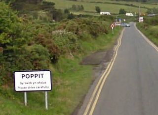
Poppit is a small, dispersed settlement which lies on the southern side of the estuary of the River Teifi, near Cardigan, in northern Pembrokeshire, Wales.

Southerndown is a village in the Vale of Glamorgan, in south Wales. It is southwest of Bridgend, and within the St Brides Major community, close to Llantwit Major and Ogmore-by-Sea. It is mostly known for its beach which backs Dunraven Bay, which is a popular tourist destination during the summer months and since 1972 has been part of a Heritage Coast and is part of the Southerndown Coast SSSI. When the tide is out there is an expanse of sand and pools. The cliffs are an obvious example of sedimentary rock.
Dulas Bay is a small bay on the north east coast of Anglesey, north Wales, forming the boundary between Llaneilian and Moelfre communities. The bay is bordered by three beaches.
Trebarwith Strand is a section of coastline located near the coastal settlement of Trebarwith on the north coast of Cornwall, England, UK, 2+1⁄2 miles (4.0 km) south of Tintagel. It has 800m of sandy beach contained by cliffs in which natural caves are found. The beach can only be accessed at low tide. The strand was once used to land ships to export slate from the nearby quarries while sand from the beach was used for agricultural purposes. The view from the beach is dominated by rocks 300m offshore known as Gull Rock or Otterham Rocks.

Whiteford Sands is a two-mile expanse of beach on the northern side of the Gower Peninsula, south Wales. It is the most northerly beach on Gower and sits on the edge of the Loughor estuary.

Popponesset Bay System is a group of bays located at the towns of Mashpee and Barnstable (east), on Cape Cod, Massachusetts with a southern shore bounded by water from Nantucket Sound.

Horton Beach is located in Port Eynon Bay on the south coast of the Gower Peninsula in Wales.

Blue Pool Bay is a small cove near the village of Llangennith in Gower, Wales. The cove is bordered by cliffs, and is accessible via a clifftop path and a steep, unstable path down to the beach. The beach is covered fully at high tide and takes its name from a large, natural rockpool. Rhossili Bay is nearby.
Upper Newport Bay State Marine Conservation Area (SMCA) is a marine protected area in Newport Bay in Orange County and the South Coast region of Southern California. It extends inland/northeast from the Pacific Coast Highway crossing of the bay, within the city of Newport Beach.
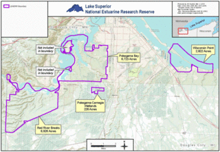
The Lake Superior National Estuarine Research Reserve includes land and water areas along the St. Louis River and Lake Superior in Douglas County, in the northwest corner of Wisconsin, United States. It is one of 29 National Estuarine Research Reserves. The Reserve is operated as a program of the Natural Resources Institute of the University of Wisconsin-Madison Division of Extension. It has an area of 16,697 acres (6,757 ha), and was designated in 2010.
