
Brownsville is a borough in Fayette County, Pennsylvania, United States, first settled in 1785 as the site of a trading post a few years after the defeat of the Iroquois enabled a resumption of westward migration after the Revolutionary War. The trading post soon became a tavern and inn and was receiving emigrants heading west, as it was located above the cut bank overlooking the first ford that could be reached to those descending from the Allegheny Mountains. Brownsville is located 40 miles (64 km) south of Pittsburgh along the east bank of the Monongahela River.

Brownsville Township is a township in Fayette County, Pennsylvania, United States. The population was 534 at the 2020 census, a decline from the figure of 683 tabulated in 2010. It is served by the Brownsville School District.

Brownsville is a city in and the county seat of Haywood County, Tennessee, United States. Its population as of the 2020 census was 9,788. The city is named after General Jacob Jennings Brown, an American officer of the War of 1812.
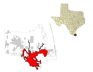
Brownsville is a city in and the county seat of Cameron County in the U.S. state of Texas. It is on the western Gulf Coast in South Texas, adjacent to the border with Matamoros, Mexico. The city covers 145.2 sq mi (376.066 km2), and had a population of 186,738 at the 2020 census. It is the 139th-largest city in the United States and 18th-largest in Texas. It is part of the Matamoros–Brownsville metropolitan area. The city is known for its year-round subtropical climate, deep-water seaport, and Hispanic culture.
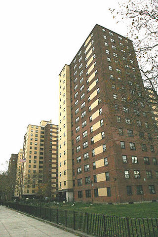
Brownsville is a residential neighborhood in eastern Brooklyn in New York City. The neighborhood is generally bordered by Crown Heights to the northwest; Bedford–Stuyvesant and Cypress Hills to the north; East New York to the east; Canarsie to the south; and East Flatbush to the west.
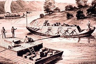
A keelboat is a riverine cargo-capable working boat, or a small- to mid-sized recreational sailing yacht. The boats in the first category have shallow structural keels, and are nearly flat-bottomed and often used leeboards if forced in open water, while modern recreational keelboats have prominent fixed fin keels, and considerable draft. The two terms may draw from cognate words with different final meaning.

In geography, statistics and archaeology, a settlement, locality or populated place is a community of people living in a particular place. The complexity of a settlement can range from a minuscule number of dwellings grouped together to the largest of cities with surrounding urbanized areas. Settlements may include hamlets, villages, towns and cities. A settlement may have known historical properties such as the date or era in which it was first settled, or first settled by particular people. The process of settlement envolves human migration

Brownsville is an unincorporated community and census-designated place (CDP) in northeastern Bowling Green Township, Licking County, Ohio, United States. As of the 2020 census, it had a population of 214. It lies at the intersection of U.S. Route 40 with State Route 668.
Brownsville is an unincorporated community and census-designated place in Washington County, Maryland, United States, near Gapland in an area known as Pleasant Valley. Its population was 89 as of the 2010 census.
The Port of Brownsville is a deep water seaport in Brownsville, at the southern tip of Texas.

The Brownsville Bridge, also known as the Intercounty Bridge and the West Brownsville Bridge, is a truss bridge that carries vehicular traffic across the Monongahela River between Brownsville, Pennsylvania and West Brownsville, Pennsylvania. Since the opening of the Lane Bane Bridge and highway project to carry much of the intercounty through traffic away from the main streets of downtown Brownsville in the early 1960s, another commonly heard name is Old Brownsville Bridge for the four high level viaduct.
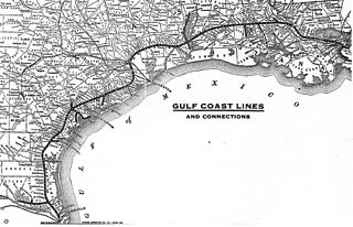
Chartered on June 6, 1903, the St. Louis, Brownsville & Mexico Railway was a 200-mile (321 km) U.S. railroad that operated from Brownsville, Texas, to Gulf Coast Junction in Houston, Texas. It served numerous towns and cities along its routes and operated a rail bridge between Brownsville and Matamoros, Tamaulipas, in junction with the Mexican government. The Brownie connected the citizens of Brownsville to nearby Corpus Christi for the first time on land rather than using water transportation.
Asphalt is an unincorporated community located in Edmonson County, Kentucky, United States.
Brownsville, also known as Avalon, Esther's Place, and Anderson's Place, is an unincorporated community in Lawrence County, South Dakota, United States. The town was originally a lumber camp, and it was named for contractor David Brown. It is the nearest community to John Hill Ranch-Keltomaki, which is listed on the U.S. National Register of Historic Places.
Brownsville is an unincorporated community in Escambia County, Florida, United States. It is located within the census-designated place of West Pensacola. It was enumerated as a Census-Designated Place in 1960, when the population recorded was 38,417. The ZIP code for Brownsville is 32505.

The University of Texas at Brownsville was an educational institution located in Brownsville, Texas. The university was on the land once occupied by Fort Brown. It was a member of the University of Texas System. The institution was formed from a 1991 partnership between the two-year Texas Southmost College and University of Texas-Pan American at Brownsville. The partnership ended in 2011 as UTB became a standalone University of Texas institution, and Texas Southmost College returned to being an independent community college. UTB itself offered baccalaureate and graduate degrees in liberal arts, sciences, education, business, and professional programs.

The unincorporated hamlet of Malden is a bedroom community that is located on the historic 'Old National Pike' in borough of Centerville Washington County, Pennsylvania. Originally an early wagon stop in rural Pennsylvania, it became a small transportation hub during the surge of westward migration to the Northwest Territory after 1790.
The Pennsylvania State Game Lands Number 280 are Pennsylvania State Game Lands in Berks County in Pennsylvania in the United States providing hunting, bird watching, and other activities.
Segal is an unincorporated community in west-central Edmonson County in south-central Kentucky, United States. Segal is part of the Bowling Green Metropolitan Statistical Area.
Anneta is an unincorporated community located in southern Grayson County, Kentucky, United States.

