
Matamoros, officially known as Heroica Matamoros, is a city in the northeastern Mexican state of Tamaulipas, and the municipal seat of the homonymous municipality. It is on the southern bank of the Rio Grande, directly across the border from Brownsville, Texas, United States. Matamoros is the second largest city in the state of Tamaulipas. As of 2016, Matamoros had a population of 520,367. In addition, the Matamoros–Brownsville Metropolitan Area has a population of 1,387,985, making it the 4th largest metropolitan area on the Mexico–US border. Matamoros is the 39th largest city in Mexico and anchors the second largest metropolitan area in Tamaulipas.

The Delaware Memorial Bridge is a dual-span suspension bridge crossing the Delaware River. The toll bridges carry Interstate 295 and U.S. Route 40 and is also the link between Delaware and New Jersey. The bridge was designed by the firm of Howard, Needles, Tammen & Bergendoff with consulting help from engineer Othmar Ammann, whose other designs include the George Washington Bridge and the Verrazzano-Narrows Bridge.

The Detroit–Windsor tunnel, also known as the Detroit–Canada tunnel, is an international highway tunnel connecting the cities of Detroit, Michigan, United States and Windsor, Ontario, Canada. It is the second-busiest crossing between the United States and Canada, the first being the Ambassador Bridge, which also connects the two cities, which are situated on the Detroit River.

The Angus L. Macdonald Bridge is a suspension bridge crossing Halifax Harbour in Nova Scotia, Canada; it opened on April 2, 1955.

The Antioch Bridge is an automobile, bicycle, and pedestrian bridge in the western United States. Located in northern California, it crosses the San Joaquin River-Stockton Deepwater Shipping Channel, linking Antioch in Contra Costa County with Sherman Island in southern Sacramento County, near Rio Vista.
The Texas Mexican Railway was a short line railroad in the U.S. state of Texas operating between Corpus Christi and the Texas Mexican Railway International Bridge in Laredo, Texas. It is often referred to as the Tex-Mex, or TexMex Railway.

The Columbia–Wrightsville Bridge, officially the Veterans Memorial Bridge, spans the Susquehanna River between Columbia and Wrightsville, Pennsylvania, and carries Pennsylvania Route 462 and BicyclePA Route S. Built originally as the Lancaster-York Intercounty Bridge, construction began in 1929, and the bridge opened September 30, 1930. On November 11, 1980, it was officially dedicated as Veterans Memorial Bridge, though it is still referenced locally as the Columbia–Wrightsville Bridge.

The Pennsylvania Railroad Bridge once carried the York Branch of the Pennsylvania Railroad across the Susquehanna River between Columbia and Wrightsville, Pennsylvania and is therefore considered a Columbia-Wrightsville Bridge. It and its predecessors were a vital commercial and passenger linkage between Philadelphia and Baltimore for over 100 years.
Gateway International Bridge is one of three international bridges that cross the U.S.-Mexico border between the cities of Brownsville, Texas, and Matamoros, Tamaulipas. It is owned and operated by Cameron County. Over the past century, it has developed the nickname of "The New Bridge" when the bridge was remodeled back in the 20th century. Despite the fact that the Veteran's International Bridge is newer than Gateway, it still retains its nickname.
The Veterans International Bridge at Los Tomates is one of three international bridges that span the Mexico–United States border between the cities of Brownsville, Texas, and Matamoros, Tamaulipas. It is also known as simply as the Veterans Bridge, the Los Tomates Bridge, the Expressway 77/83 Bridge, the Brownsville Expressway Bridge, and on the Mexico side as the Puente Internacional General Ignacio Zaragoza. The bridge is owned and operated by Cameron County.
The Progreso–Nuevo Progreso International Bridge, officially the Weslaco–Progreso International Bridge and also known as the B&P Bridge, is an international bridge over the Rio Grande on the U.S.–Mexico border, connecting the cities of Progreso, Texas and Nuevo Progreso, Río Bravo, Tamaulipas. It has been in operation since 1952.
The Elm Park Bridge, sometimes locally referred to as the BDI Bridge or the Ice Cream Bridge, is a steel truss bridge over the Red River in Winnipeg, Manitoba.

Moore's Crossing Historic District is a community located in rural Travis County nine miles southeast of Austin, Texas near the Austin–Bergstrom International Airport.
The John F. Kennedy Memorial Causeway is a paved highway located in Corpus Christi, Texas. The causeway crosses the Laguna Madre and connects North Padre Island with Flour Bluff on the Texas mainland.
The Sion Panvel Expressway is a 25 km Indian highway located entirely in the state of Maharashtra, that connects Sion in Mumbai with Panvel, via Navi Mumbai. It is one of the busiest and most important roads in the Mumbai Metropolitan Region (MMR) and connects Mumbai with the city of Pune. The National Highway 4 and Mumbai-Pune Expressway begin at the eastern end of the expressway, at Kalamboli junction, near Panvel. The highway is also used by vehicles traveling towards Mumbai from Konkan and Goa.
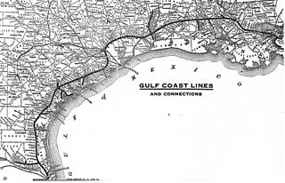
The Gulf Coast Lines was the name of a railroad system comprising three principal railroads, as well as some smaller ones, that stretched from New Orleans, Louisiana, via Baton Rouge and Houston to Brownsville, Texas. Originally chartered as subsidiaries of the Frisco Railroad, the system became independent in 1916 and was purchased by the Missouri Pacific Railroad in 1925.

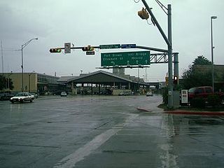
The Brownsville B&M Port of Entry opened in 1909 with the completion of the Brownsville & Matamoros International Bridge. The bridge was built to carry trains, horses, wagons and pedestrians. The original bridge could swing open to allow river traffic to pass; however it was a function that was almost never used due to the shallowness of the Rio Grande. The bridge was substantially renovated in 1953, and a second 4-lane bridge dedicated to northbound traffic was built adjacent to it in 1997. Since 1999, all truck traffic has been diverted to the Veterans and Los Indios crossings.
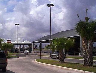
The Brownsville Veterans Port of Entry opened in 1999 with the completion of the Veterans International Bridge at Los Tomates. The bridge was built primarily to divert commercial freight traffic away from the busy downtown bridges, but about a third of the passenger vehicles also cross at this point. The Veterans Port of Entry is the easternmost US-Mexico border crossing, and is by far the newest of the three crossings between Brownsville and Matamoros.

Terminology related to road transport—the transport of passengers or goods on paved routes between places—is diverse, with variation between dialects of English. There may also be regional differences within a single country, and some terms differ based on the side of the road traffic drives on. This glossary is an alphabetical listing of road transport terms.


