
Mere is a market town and civil parish in Wiltshire, England. It lies at the extreme southwestern tip of Salisbury Plain, close to the borders of Somerset and Dorset. The parish includes the hamlets of Barrow Street, Burton, Charnage, Limpers Hill, Rook Street and Southbrook.

The Vale of Pewsey or Pewsey Vale is an area of Wiltshire, England to the east of Devizes and south of Marlborough, centred on the village of Pewsey.

Collingbourne Ducis is a village and civil parish on Salisbury Plain in Wiltshire, England, about 10 miles (16 km) south of Marlborough. It is one of several villages on the River Bourne which is a seasonal river, usually dry in summer. The parish includes the hamlets of Cadley and Sunton.

Chilton Foliat is a village and civil parish on the River Kennet in Wiltshire, England. The parish is in the North Wessex Downs Area of Outstanding Natural Beauty. It is on the county boundary with West Berkshire and is about 1.5 miles (2.4 km) northwest of the Berkshire market town of Hungerford.

Collingbourne Kingston is a village and civil parish about 8 miles (13 km) south of the market town of Marlborough in Wiltshire, England. The village, which is on the A338 primary route between Andover and Marlborough, is one of several on the River Bourne, a seasonal river which is usually dry in summer. The parish includes the hamlets of Aughton and Brunton.

The River Bourne is a river in the English county of Wiltshire, a tributary of the Salisbury Avon. It flows in a generally southerly direction for about 48 km. In its upper reaches the river is a winterbourne, often dry in summer.
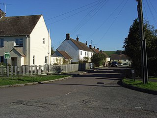
Aughton is a hamlet adjacent to the village of Collingbourne Kingston in Wiltshire, England.

The Wiltshire Victoria County History, properly called The Victoria History of the County of Wiltshire but commonly referred to as VCH Wiltshire, is an encyclopaedic history of the county of Wiltshire in England. It forms part of the overall Victoria County History of England founded in 1899 in honour of Queen Victoria. With eighteen volumes published in the series, it is now the most substantial of the Victoria County Histories.
Richard Long was an English politician.

Hyde Abbey was a medieval Benedictine monastery just outside the walls of Winchester, Hampshire, England. It was dissolved and demolished in 1538 following various acts passed under King Henry VIII to dissolve monasteries and abbeys. The Abbey was once known to have housed the remains of King Alfred the Great, his son, King Edward the Elder, and his wife, Ealhswith. Following its dissolution these remains were lost; however, excavations of the Abbey and the surrounding area continue.
Great Bedwyn was a parliamentary borough in Wiltshire, centred on Great Bedwyn, which elected two Members of Parliament (MPs) to the House of Commons from 1295 until 1832, when the borough was abolished by the Great Reform Act.

Netheravon is a village and civil parish on the River Avon and A345 road, about 4 miles (6.4 km) north of the town of Amesbury in Wiltshire, South West England. It is within Salisbury Plain.

Longbridge Deverill is a village and civil parish about 2.5 miles (4.0 km) south of Warminster in Wiltshire, England. It is on the A350 primary route which connects the M4 motorway and west Wiltshire with Poole, Dorset.

Brixton Deverill is a small village and civil parish about 4 miles (6.4 km) south of Warminster in Wiltshire, England.

Collingbourne railway station served the village of Collingbourne Ducis in Wiltshire, England. It was on the Midland and South Western Junction Railway (M&SWJR) and opened on 1 May 1882 on the southern section of the Swindon, Marlborough and Andover Railway (SM&AR) which at that stage terminated at the-then next station to the north, Grafton and Burbage. In 1883, the SM&AR gained running rights over the Great Western Railway branch from Savernake Low Level to Marlborough and through services started between Swindon Town and Andover Junction railway station, and on down the Sprat and Winkle Line to Southampton. The same year, the Swindon and Cheltenham Extension Railway (S&CER) opened north of Swindon as far as Cirencester and in 1884 the SM&AR and the S&CER merged to form the M&SWJR. The line was completed as a through-route from the Midlands to the south coast by the completion of the northern end of the route between Cirencester and Cheltenham in 1891.
Collingbourne Kingston Halt was a small railway station that served the village of Collingbourne Kingston in Wiltshire, England for less than 30 years. The station was on the former Midland and South Western Junction Railway, which was a north–south through-route between the Midlands and the south coast ports and which had been built through Collingbourne Kingston in 1882.

Monkton Deverill is a village and former civil parish in Wiltshire, England, about five miles south of Warminster and four miles north-east of Mere. The area has been part of Kingston Deverill parish since 1938. It lies on the River Wylye and forms part of a group of villages known as the Upper Deverills.

Kingston Deverill is a village and civil parish in Wiltshire, England. Its nearest towns are Mere, about 3+1⁄2 miles (6 km) to the southwest, and Warminster, about 5 miles (8 km) to the northeast. The parish and its demographic figures include the village of Monkton Deverill.
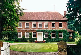
Brunton House is a Grade II* listed house in Brunton, Wiltshire, England. It dates from the late seventeenth or early eighteenth centuries and is of brick with flint panels and a tiled roof.

