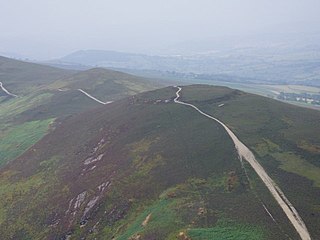
Ramparts of Buarth-y-Gaer, along southeast side. | |
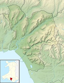
Location | summit of Mynydd-y-Gaer, Neath Port Talbot, Wales (OS Grid ref SS765939) |
---|---|
Region | South Wales |
Coordinates | 51°37′39″N3°47′06″W / 51.6276°N 3.7849°W Coordinates: 51°37′39″N3°47′06″W / 51.6276°N 3.7849°W |
Type | Hillfort |
Area | 1.1 ha (2.7 acres) |
History | |
Periods | Iron Age |
Cultures | Celtic Brittonic |
Site notes | |
Condition | A single bank and ditch, damaged by quarrying on south side. |
Public access | No |
Reference no. | GM054 |
Buarth-y-Gaer (pronounced [ˈbɪ.arθ ə ɡɑːɨr] ) is an Iron Age hillfort or enclosure on the summit of Mynydd-y-Gaer, 300 m (980 ft) above sea level. It is in Briton Ferry community, near Neath, in Neath Port Talbot, South Wales. A large hilltop enclosure is bounded by a single bank and ditch. Within the enclosed area is a Bronze Age burial mound.
The Iron Age is the final epoch of the three-age system, preceded by the Stone Age (Neolithic) and the Bronze Age. It is an archaeological era in the prehistory and protohistory of Europe and the Ancient Near East, and by analogy also used of other parts of the Old World. The three-age system was introduced in the first half of the 19th century for the archaeology of Europe in particular, and by the later 19th century expanded to the archaeology of the Ancient Near East. Its name harks back to the mythological "Ages of Man" of Hesiod. As an archaeological era it was first introduced for Scandinavia by Christian Jürgensen Thomsen in the 1830s. By the 1860s, it was embraced as a useful division of the "earliest history of mankind" in general and began to be applied in Assyriology. The development of the now-conventional periodization in the archaeology of the Ancient Near East was developed in the 1920s to 1930s. As its name suggests, Iron Age technology is characterized by the production of tools and weaponry by ferrous metallurgy (ironworking), more specifically from carbon steel.
A hillfort is a type of earthworks used as a fortified refuge or defended settlement, located to exploit a rise in elevation for defensive advantage. They are typically European and of the Bronze and Iron Ages. Some were used in the post-Roman period. The fortification usually follows the contours of a hill, consisting of one or more lines of earthworks, with stockades or defensive walls, and external ditches. Hillforts developed in the Late Bronze and Early Iron Age, roughly the start of the first millennium BC, and were used in many Celtic areas of central and western Europe until the Roman conquest.
Mynydd-y-Gaer is a hill that sits on the boundaries between the South Wales communities of Baglan, Cwmavon and Briton Ferry,, all within Neath Port Talbot county borough. The summit, at 314 m (1,030 ft), has grassland fields subdivided by dry stone walls. Foel Fynyddau lies 2 km to east. To the south is the coastal plain of the Severn Estuary. To the West is the Vale of Neath. To the north is the Crythan Brook and the town of Neath. It has numerous prehistoric monuments, and evidence of occupation in medieval times, as well as 19th and 20th century coalmining.
The hillfort is on the highest point of Mynydd-y-Gaer. It is one of three hillforts on this broad upland ridge; Craig Ty-Isaf is a much smaller hillfort to the south-west, close to Baglan, whilst Gaer Fawr is 800 m (870 yd) to the north. Mynydd-y-Gaer has a rounded hilltop, with grassland fields and stone walls running up to Buarth-y-Gaer. The hill stands above the Neath estuary and Briton Ferry, on the other side of Briton Ferry Woods, some 3 km (1.9 mi) to the north-west. [1] The village of Baglan is at the foot of the hill, 1 km (0.62 mi) to the south-west. A slightly higher mountain, Foel Fynyddau lies to the east. Although the hillfort lies within Briton Ferry community, the south and east banks of the fort are on the boundary with Baglan community.
Craig Ty-Isaf is a small hillfort in Baglan community, Neath Port Talbot, in South Wales. It is one of three hillforts on the area of hillside known as Mynydd y Gaer, and is within Briton Ferry Woods. The hillfort is on the SW side of the hill, overlooking Baglan, an oval enclosing some 0.2ha. A broad rubble bank forms the oval enclosure, and on the east two further banks mean that the area of banks and ditches encompasses a much larger area for the site as a whole, which is a Scheduled Monument. There are various internal features thought to be the result of more recent test cuts for mineral extraction.
Baglan is a large village in Wales, adjoining Port Talbot, named after Saint Baglan. Baglan is also a community and ward in the Neath Port Talbot county borough. In 2001, the population was 6,654.
The fort is defined by a single bank and ditch which are roughly circular. It is 130 m (140 yd) across and encloses 1.1 ha (2.7 acres) of rough grassland. Small-scale early quarrying has removed some of the bank from the south side. The remainder has several modern gaps and an original entrance on the west side. The bank stands half a metre above the interior, with a 2 m (6.6 ft) drop from the bank to the bottom of the ditch. The site is a scheduled monument. [1] Although the hill name is 'Mynydd-y-Gaer' (Mountain of the Fort) and the scheduling classifies it as a hillfort, the site shows little evidence of defensibility or fortification, and may be better termed an enclosure [2] or 'defended enclosure'. [3]
In the United Kingdom, a scheduled monument is a "nationally important" archaeological site or historic building, given protection against unauthorised change.
In archaeology, an enclosure is one of the most common types of archaeological site. It is any area of land separated from surrounding land by earthworks, walls or fencing. Such a simple feature is found all over the world and during almost all archaeological periods. They may be few metres across or be large enough to encompass whole cities.
A Bronze Age burial mound, which pre-dates the hillfort, stands within the enclosed area as the only internal feature. This is 0.8 m high, and 11.6 m (38 ft) across. [4]
The Bronze Age is a historical period characterized by the use of bronze, and in some areas proto-writing, and other early features of urban civilization. The Bronze Age is the second principal period of the three-age Stone-Bronze-Iron system, as proposed in modern times by Christian Jürgensen Thomsen, for classifying and studying ancient societies.
Briton Ferry is a town and community in the county borough of Neath Port Talbot, Wales. The town encompasses the electoral wards of Briton Ferry East and Briton Ferry West.
Merthyr Mawr is a village and community in Bridgend, Wales. The village is about 2½ miles from the centre of Bridgend town. The population of the community at the 2011 census was 267. The community occupies the area west of the Ewenny River, between Bridgend and Porthcawl. It takes in the settlement of Tythegston and a stretch of coastal sand dunes known as Merthyr Mawr Warren.
Margam Country Park is a country park estate in Wales, of around 850 acres (3.4 km²). It is situated in Margam, about 2 miles (3 km) from Port Talbot in south Wales. It was once owned by the Mansel Talbot family and is now owned and administered by the local council, Neath Port Talbot County Borough Council. Situated within the park are three notable buildings: Margam Abbey, a Cistercian monastery; Margam Castle, a neo-Gothic country house that was once the seat of the Mansel Talbot family; and the 18th-century Orangery.
The Baglan electoral ward includes the communities of Baglan and Baglan Bay, in Neath Port Talbot county borough, Wales. Baglan falls within the parliamentary constituency of Aberavon.
Moel y Gaer is an Iron Age hillfort on a summit of Llantysilio Mountain, northwest of the town of Llangollen, Denbighshire, Wales. The site is a scheduled monument classified as a prehistoric defensive hillfort.
Foel Chwern is a Round cairn on the edge of the high plateau east of the Neath valley, and near the summit of Craig y Llyn. The headwaters of the River Rhondda are to the south-west. It is a burial monument dating to the Bronze Age, and is sited on the edge of a steep scarp slope, with a wide field of view to the north. The long distance footpath Coed Morgannwg Way runs close by the cairn. Conifer plantations of the Rheola Forest surround the site.
Wenallt Camp, also known as Wenallt Enclosure, is an iron age enclosure near Rhiwbina, Cardiff, in South Wales, although some consider the camp a hillfort. The camp is a scheduled monument.