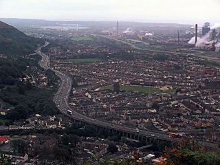
Port Talbot is a town and community in the county borough of Neath Port Talbot, Wales, situated on the east side of Swansea Bay, approximately eight miles from Swansea. The Port Talbot Steelworks covers a large area of land which dominates the south east of the town and is one of the biggest steelworks in the world but has been under threat of closure since the 1980s. The population was 37,276 in 2011.

Neath is a market town and community situated in the Neath Port Talbot County Borough, Wales. The town had a population of 50,658 in 2011. The community of the parish of Neath had a population of 19,258 in 2011. Historically in Glamorgan, the town is located on the River Neath, seven miles east-northeast of Swansea.

Briton Ferry is a town and community in the county borough of Neath Port Talbot, Wales. The Welsh name may indicate that the church, llan, is protected from the wind, awel. Alternatively, Sawel may be a derivative of Saul, St Paul's earlier name. He once landed at Briton Ferry. An alternative Welsh name unused today is Rhyd y Brython, a direct translation of Briton Ferry. The Normans referred to the River crossing as La Brittonne and Leland in 1540 as Britanne Fery.

Baglan is a large village in Wales, adjoining Port Talbot, named after Saint Baglan. Baglan is also a community and ward in the Neath Port Talbot county borough. In 2001, the population was 6,654. rising to 6,819 in 2011.

The Baglan electoral ward includes the communities of Baglan and Baglan Bay, in Neath Port Talbot county borough, Wales. Baglan falls within the parliamentary constituency of Aberavon.
Moel y Gaer is an Iron Age hillfort on a summit of Llantysilio Mountain, northwest of the town of Llangollen, Denbighshire, Wales. The site is a scheduled monument classified as a prehistoric defensive hillfort.

Burfa Castle is an Iron Age hillfort near the tiny town of Old Radnor, Radnorshire in Powys, Wales. The site is a scheduled monument described as a prehistoric defensive hillfort, and was included in an inventory of monuments by 1913. The site is near Offa's Dyke which passes near the bottom of Burfa Bank.

Chiselbury is the site of an Iron Age univallate hillfort located in Wiltshire. The hillfort is sub-circular in plan, and encloses an area of approximately 10.5 acres (460,000 sq ft). It is defined by an earthen rampart up to 3.6 metres (12 ft) in height and an external ditch, up to a maximum of 1.6 metres (5.2 ft) in depth. A gap in the southeastern side of the rampart, and a corresponding causeway across the ditch, is thought to be the original entrance and is associated with a small 'D' shaped embanked enclosure, which is apparently visible on aerial photographs. Although the enclosure has subsequently been degraded by ploughing, it is still apparent as a series of low earthworks.
Llandyssil is a village in Powys, Wales, about two miles from the town of Montgomery.

Caerau Hillfort is a large triangular multivallate Iron Age hillfort, built on a previously occupied Neolithic site, occupying the western tip of an extensive ridge-top plateau in the western suburbs of Caerau and Ely, Cardiff, Wales. It is the largest Iron Age site of its type in south Wales and also one of the largest in Great Britain. The old parish church, St Mary's, and a small ringwork, almost certainly a medieval castle site probably contemporary with the church, stand within the hillfort on the north-eastern side.

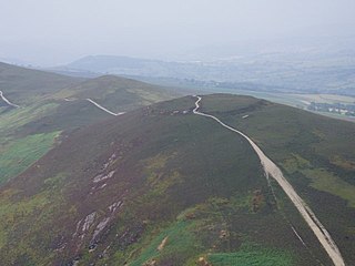
Mynydd-y-Gaer is a hill that sits on the boundaries between the South Wales communities of Baglan, Cwmavon and Briton Ferry,, all within Neath Port Talbot county borough. The summit, at 314 m (1,030 ft), has grassland fields subdivided by dry stone walls. Foel Fynyddau lies 2 km to east. To the south is the coastal plain of the Bristol Channel. To the West is the Vale of Neath. To the north is the Crythan Brook and the town of Neath. It has numerous prehistoric monuments, and evidence of occupation in medieval times, as well as 19th and 20th century coalmining.
Foel Chwern is a Round cairn on the edge of the high plateau east of the Neath valley, and near the summit of Craig y Llyn. The headwaters of the River Rhondda are to the south-west. It is a burial monument dating to the Bronze Age, and is sited on the edge of a steep scarp slope, with a wide field of view to the north. The long distance footpath Coed Morgannwg Way runs close by the cairn. Conifer plantations of the Rheola Forest surround the site.
Buarth-y-Gaer is an Iron Age hillfort or enclosure on the summit of Mynydd-y-Gaer, 300 m (980 ft) above sea level. It is in Briton Ferry community, near Neath, in Neath Port Talbot, South Wales. A large hilltop enclosure is bounded by a single bank and ditch. Within the enclosed area is a Bronze Age burial mound.
Llwynda-Ddu Camp, also known as Llwynda-Ddu Hillfort, is a small Iron Age earthwork in Pentyrch, Cardiff in South Wales. The site is a scheduled monument, described as a prehistoric, defensive hillfort.
Wenallt Camp, also known as Wenallt Enclosure, is an Iron Age enclosure on the southern slope of Wenallt Hill near Rhiwbina in Cardiff, Wales. The site is sometimes classified as a hillfort. The camp is a scheduled monument.

Bedd-y-Cawr Hillfort, or Bedd y Cawr Hillfort, is an Iron Age hillfort on a natural inland promontory in the community of Cefnmeiriadog in Denbighshire in North Wales. The name of the hillfort translates from the Welsh as Giant's Tomb.

Caer Euni [Grid reference SJ 00027 41266] is an Iron Age hillfort, about 2.5 miles (4 km) north-east of the village of Llandderfel and about 5 miles (8 km) north-east of Bala Lake, in Gwynedd, Wales. It is a scheduled monument.
