
Brunei, formally Brunei Darussalam, is a country in Southeast Asia, situated on the northern coast of the island of Borneo. Apart from its coastline on the South China Sea, it is completely surrounded by the Malaysian state of Sarawak, with its territory bifurcated by the Sarawak district of Limbang. Brunei is the only sovereign state entirely on Borneo; the remainder of the island is divided between Malaysia and Indonesia. As of 2020 the country had a population of 460,345, of whom approximately 100,000 resided in the capital and largest city Bandar Seri Begawan. The government of Brunei is an absolute monarchy ruled by the Sultan of Brunei, and it implements a fusion of English common law and jurisprudence inspired by Islam, including sharia.

Bandar Seri Begawan is the capital city of Brunei. It is officially a municipal area with an area of 100.36 square kilometres (38.75 sq mi) and an estimated population of 100,700 as of 2007. It is part of Brunei-Muara District, the smallest yet most populous district which is home to over 70 per cent of the country's population. It is the country's largest urban centre and nominally the country's only city. The capital is home to Brunei's seat of government, as well as a commercial and cultural centre. It was formerly known as Brunei Town until it was renamed in 1970 in honour of Sultan Omar Ali Saifuddien III, the 28th Sultan of Brunei and the father of the current Sultan Hassanal Bolkiah.

Omar Ali Saifuddien Sa'adul Khairi Waddien was the 28th Sultan of Brunei, reigning from 1950 until his abdication from the throne in 1967.

The Istana Nurul Iman is the official residence of the Sultan of Brunei, Hassanal Bolkiah, and the seat of the Brunei government. The palace is located on a leafy, riverside sprawl of hills on the banks of the Brunei River, a few kilometres southwest of Bandar Seri Begawan, Brunei's capital city. The palace is often at the centre of state occasions and royal hospitality.

The Brunei River is a river which flows through Brunei and empties into the Brunei Bay towards the north-east direction. The Istana Nurul Iman, the official residence of the Sultan of Brunei, stands on its banks. The Brunei River is the shortest major river in Brunei. It is the major river basin within the Brunei-Muara District, the smallest but most populous district. It flows through the country's capital Bandar Seri Begawan. It is home to Kampong Ayer, the Brunei's traditional village on stilts above the river water.
Paduka Seri Begawan Sultan Science College is a selective government secondary school and sixth form college in Bandar Seri Begawan, Brunei. It was founded in 1966 and is named after the 28th Sultan of Brunei, Sultan Omar Ali Saifuddien III.

Kampung Ayer is a prominent traditional settlement in Bandar Seri Begawan, the capital of Brunei. It comprises neighbourhoods of traditional houses, schools and mosques built on stilts above the Brunei River near the capital's city centre. It has an area of about 10 square kilometres (3.9 sq mi); the total population was 10,250 in 2016. It has been historically nicknamed 'Venice of the East'. Kampung Ayer has been historically the principal settlement of Brunei; it was the de facto capital, in particular social and economic centre, of the Bruneian Empire for a few centuries, but also extending into the early period during British imperialism in Brunei.

Hashim Jalilul Alam Aqamaddin was the 25th Sultan of Brunei from 1885 to 1906.

Pusat Bandar is the city centre of Bandar Seri Begawan, the capital of Brunei. It is home to a number of national landmarks, important government offices, and commercial and financial establishments.

The Malay Technology Museum is a museum in Kota Batu, a historical area in Bandar Seri Begawan, Brunei. It was opened in 1988 and contains exhibits on the traditional technologies used by the indigenous people of Brunei.
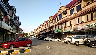
Kampong Kiulap or commonly known as Kiulap, is a village in Brunei-Muara District, Brunei, as well as a neighbourhood and commercial area in the capital Bandar Seri Begawan. It has an area of 176.53 hectares ; the population was 3,400 in 2016. It is one of the villages within Mukim Gadong 'B'. The postcode is BE1518.

Kampong Pancha Delima is a village in Brunei-Muara District, Brunei, and a neighbourhood in the capital Bandar Seri Begawan. The population was 1,562 in 2016. It is one of the villages within Mukim Berakas 'A'. The postcode is BB4513.

Kampong Kiarong or commonly known as Kiarong, is a village in Brunei-Muara District, Brunei, as well as a neighbourhood in the country's capital Bandar Seri Begawan. It has an area of 383.43 hectares ; the population was 4,530 in 2016.

Kampong Kumbang Pasang, or simply Kumbang Pasang, is a village within Mukim Kianggeh in Brunei-Muara District, Brunei. It is also part of the municipal area of the capital Bandar Seri Begawan. The population was 563 in 2016. It has the postcode BA1511. The village formerly hosts a rubber plantation and was named Kumbang Pasang Estate. Notably the village was once its own Mukim, known as Mukim Kumbang Pasang.

Kampong Pengiran Siraja Muda Delima Satu is a village in Brunei-Muara District, Brunei, and a neighbourhood in the capital Bandar Seri Begawan. The population was 2,354 in 2016. It is one of the villages within Mukim Berakas 'A'. The postcode is BB5113.
The Kianggeh Dagang Muslim Cemetery, also known as the Residency Muslim Cemetery, is a Muslim burial ground located at Kianggeh in Bandar Seri Begawan, the capital of Brunei Darussalam. The cemetery was formerly a Royal burial ground which known as Bukit Tinggi Royal Mausoleum which served as resting place for past Sultans of Brunei. The first Sultan of Brunei buried here was Sultan Saiful Rijal, the 7th Sultan of Brunei who died in 1581.

The Old Lapau, formerly known as the Lapau, is a historical building in Bandar Seri Begawan, Brunei. It was the former lapau or royal ceremonial hall prior to the existence of the current Lapau building. It was also where the Constitution of Brunei was promulgated in 1959. It now houses a museum pertaining to the Constitution.

Berambang Island is an island at the southern bank of the Brunei River in the Mukim Kota Batu, Brunei-Muara District, Brunei. The island was formerly named Buang Tawer during The Brooke Era from 1841 until 1941. The mausoleum of the 9th Sultan of Brunei, Sultan Muhammad Hassan is located on the island, near Kampong Sungai Bunga.

Pengiran Anak Damit was the Queen consort of Brunei as the wife of the 28th Sultan of Brunei, Omar Ali Saifuddien III.

Brunei Energy Hub Dermaga Diraja or Brunei Energy Hub in short, is the new name of the historic Royal Customs and Excise Building in Pusat Bandar, Brunei-Muara District, Brunei. The renovation project, which was entirely sponsored by Brunei Shell Petroleum (BSP), has been transformed into Brunei-Muara's very own interactive oil and gas museum. The museum, which is located alongside the Royal Wharf and has the Raja Isteri Pengiran Anak Hajah Saleha Bridge as a backdrop, seeks to act as a knowledge centre for the oil and gas sector and a venue to encourage the growth of Brunei's artistic scene.
