Emery County is a county in east-central Utah, United States. As of the 2020 United States Census, the population was 9,825. Its county seat is Castle Dale, and the largest city is Huntington.

Emery is a town in Emery County, Utah, United States. The population was 288 at the 2010 census.
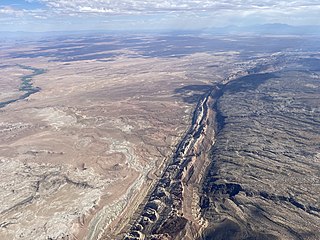
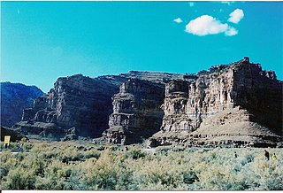
The San Rafael Swell is a large geologic feature located in south-central Utah, United States about 16 miles (26 km) west of Green River. The San Rafael Swell, measuring approximately 75 by 40 miles, consists of a giant dome-shaped anticline of sandstone, shale, and limestone that was pushed up during the Paleocene Laramide Orogeny 60–40 million years ago. Since that time, infrequent but powerful flash floods have eroded the sedimentary rocks into numerous valleys, canyons, gorges, mesas, buttes, and badlands.

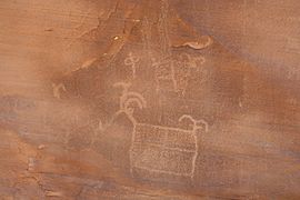
The Fremont culture or Fremont people is a pre-Columbian archaeological culture which received its name from the Fremont River in the U.S. state of Utah, where the culture's sites were discovered by local indigenous peoples like the Navajo and Ute. In Navajo culture, the pictographs are credited to people who lived before the flood. The Fremont River itself is named for John Charles Frémont, an American explorer. It inhabited sites in what is now Utah and parts of Nevada, Idaho, Wyoming and Colorado from AD 1 to 1301. It was adjacent to, roughly contemporaneous with, but distinctly different from the Ancestral Pueblo peoples located to their south.

Goblin Valley State Park is a state park of Utah, in the United States. The park features thousands of hoodoos, referred to locally as goblins, which are formations of mushroom-shaped rock pinnacles, some as tall as several yards (meters). The distinct shapes of these rocks result from an erosion-resistant layer of rock atop relatively softer sandstone. Goblin Valley State Park and Bryce Canyon National Park, also in Utah about 190 miles (310 km) to the southwest, contain some of the largest occurrences of hoodoos in the world.

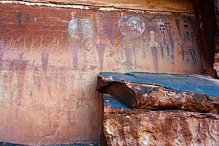
Thompson Springs, also officially known for a time as just Thompson, is a small census-designated place in central Grand County, Utah, United States. The population was 39 at the 2010 census. The town is just north of the east–west highway route shared by Interstate 70, U.S. Route 6 and U.S. Route 50, between Crescent Junction and Cisco. Moab, the county seat, is 37 miles (60 km) to the south. Thompson Springs is located in high desert country at an elevation of 5,246 feet (1,599 m), with the Book Cliffs just to the north. The town's ZIP code is 84540. The mystery "The Silver Spur Cafe" by Chinle Miller is partially set in Thompson Springs.

Interstate 70 (I-70) is a mainline route of the Interstate Highway System in the United States connecting Utah and Maryland. The Utah section runs east–west for approximately 232 miles (373 km) across the central part of the state. Richfield is the largest Utah city served by the freeway, which does not serve or connect any urban areas in the state. The freeway was built as part of a system of highways connecting Los Angeles and the Northeastern United States. I-70 was the second attempt to connect southern California to the east coast of the United States via central Utah, the first being a failed attempt to construct a transcontinental railroad. Parts of that effort were reused in the laying out of the route of I-70.
Ninemile Canyon is a canyon, approximately 40 miles (64 km) long, located in Carbon and Duchesne counties in eastern Utah, United States. Promoted as "the world's longest art gallery", the canyon is known for its extensive rock art, most of it created by the Fremont culture and the Ute people. The rock art, shelters, and granaries left behind by the Fremont make Ninemile Canyon a destination for archaeologists and tourists alike.

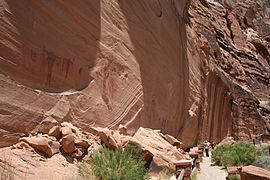
Horseshoe Canyon, formerly known as Barrier Canyon, is in a remote area west of the Green River and north of the Canyonlands National Park Maze District in Utah, United States. It is known for its collection of Barrier Canyon Style (BCS) rock art, including both pictographs and petroglyphs, which was first recognized as a unique style here. A portion of Horseshoe Canyon containing The Great Gallery is part of a detached unit of Canyonlands National Park. The Horseshoe Canyon Unit was added to the park in 1971 in an attempt to preserve and protect the rock art found along much of its length.
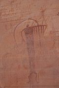
Barrier Canyon Style (BCS) describes a distinctive style of rock art which appears mostly in Utah, with the largest concentration of sites in and around the San Rafael Swell and Canyonlands National Park, but the full range extends into much of the state and western Colorado. The term was first applied by Polly Schaafsma to describe a handful of similar sites known at the time, including several along Barrier Creek in Horseshoe Canyon. Barrier Canyon Style rock art panels are mostly pictographs (painted) but there are also several petroglyphs (pecked) in the style. These panels are believed to have been created during the archaic period and are estimated to be somewhere in the range of 1500 to 4000 years old, possibly older -- clay figurines of a similar style found in Cowboy Cave have been dated to over 7000 years old.

The Prehistoric Museum, USU-Eastern, formerly known as the College of Eastern Utah Prehistoric Museum, is a museum accredited by the American Alliance of Museums located in Price, Utah. The museum seeks to promote public understanding of prehistory through interpretive exhibits, educational programs, collections, and research. The museum is located near many paleontological and archaeological sites in a region known as Castle Country, notably in the San Rafael Swell and nearby canyons throughout the Book Cliffs area such as Nine Mile Canyon and Range Creek Canyon.
Millsite is a pictograph area in south-central Utah, USA in the San Rafael Swell, four miles west of the town of Ferron. There are four main rock faces, called panels, in the Millsite area, which were utilized for pictographic art.

Painting in the Americas before European colonization is the Precolumbian painting traditions of the Americas. Painting was a relatively widespread, popular and diverse means of communication and expression for both religious and utilitarian purpose throughout the regions of the Western Hemisphere. During the period before and after European exploration and settlement of the Americas; including North America, Central America, South America and the islands of the Caribbean, the Bahamas, the West Indies, the Antilles, the Lesser Antilles and other island groups, indigenous native cultures produced a wide variety of visual arts, including painting on textiles, hides, rock and cave surfaces, bodies especially faces, ceramics, architectural features including interior murals, wood panels, and other available surfaces. Many of the perishable surfaces, such as woven textiles, typically have not been preserved, but Precolumbian painting on ceramics, walls, and rocks have survived more frequently.
The Quail rock art panel is a panel of Native American rock art located at the intersect of Grand Gulch and Step Canyon in Cedar Mesa, San Juan County, Utah. Grand Gulch contains a large number of relatively well-preserved rock art and ledge dwellings. The Quail Panel is a grouping of pictographs that were probably created by people of the Basketmaker II or Fremont culture. Cedar Mesa is located at a point where the two cultures overlapped.
The Observant Man Panel, also known as The Hidden Images Panel, is a panel of Barrier Canyon Style pictographs along the Swallow Nest Creek in Utah, United States.

Quitchupah Creek is a stream draining portions of Emery and Sevier Counties in central Utah, in the western United States. Quitchupah Creek is significant for rock art remains of the Fremont culture that line its banks. Quitchupah is Ute for "animals fare poorly." The drainage area is located within the Colorado River Basin near the south end of the Wasatch Plateau. All drainage from the area flows to Quitchupah Creek or its tributaries, including East Spring Canyon, Water Hollow, and North Fork and flows through Convulsion Canyon.
The Courthouse Wash Pictographs are a series of large pictographs created over a long period of time, located on a sheltered sandstone wall at the mouth of Courthouse Wash, Arches National Park in Grand County, Utah, United States, just north of Moab, that is listed on the National Register of Historic Places (NRHP).

Cañon Pintado, meaning painted canyon, is an archaeological site of Native American rock art located in the East Four Mile Draw, 10.5 miles (16.9 km) south of Rangely in Rio Blanco County, Colorado. Led by Ute guides, the Domínguez–Escalante expedition, Spanish missionaries in search of a route to California in 1776, passed through this region as they moved north and then west into Utah. The first Europeans to the area, they named it Cañon Pintado, meaning "painted canyon".

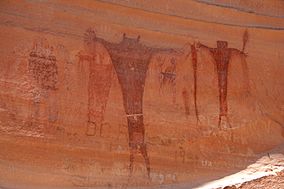
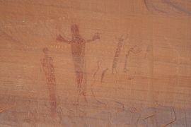
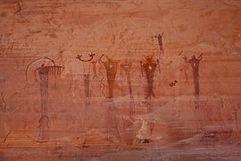
The Thompson Wash Rock Art District, known by the Bureau of Land Management as the Sego Canyon Rock Art Interpretive Site, is a rock art site in Grand County, Utah, north of the town of Thompson Springs. It contains art from three different cultures: the Fremont, the Ute, and the Barrier Canyon Style.