
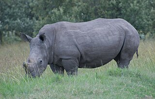
Maasai Mara, also sometimes spelled Masai Mara and locally known simply as The Mara, is a large national game reserve in Narok, Kenya, contiguous with the Serengeti National Park in Tanzania. It is named in honour of the Maasai people, the ancestral inhabitants of the area, who migrated to the area from the Nile Basin. Their description of the area when looked at from afar: "Mara" means "spotted" in the local Maasai language, due to the many short bushy trees which dot the landscape.

Kloof is a leafy upper-class town, that includes a smaller area called Everton, located approximately 26 km north-west of Durban in KwaZulu-Natal, South Africa. Once an independent municipality, it now forms part of greater Durban area of the eThekwini Metropolitan Municipality.
Wakkerstroom is the second oldest town in Mpumalanga province, South Africa. The town is on the KwaZulu-Natal border, 27 km east of Volksrust and 56 km south-east of Amersfoort.
Gillitts is a town in the KwaZulu-Natal Province of South Africa.

Thomas More College is an independent, co-educational day school located in Kloof, near Durban in KwaZulu-Natal, South Africa.
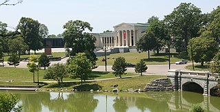
Many of the public parks and parkways system of Buffalo, New York were originally designed by Frederick Law Olmsted and Calvert Vaux between 1868 and 1896. They were inspired in large part by the parkland, boulevards, and squares of Paris, France. They include the parks, parkways and circles within the Cazenovia Park–South Park System and Delaware Park–Front Park System, both listed on the National Register of Historic Places and maintained by the Buffalo Olmsted Parks Conservancy.

The Richtersveld is a desert landscape characterised by rugged kloofs and high mountains, situated in the north-western corner of South Africa’s Northern Cape province. It is full of changing scenery from flat, sandy, coastal plains, to craggy sharp mountains of volcanic rock and the lushness of the Orange River, which forms the border with neighboring Namibia. The area ranges in altitude from sea level, to 1,377 m (4,518 ft) at Cornellberg. Located in the north-western side of the Northern Cape province in South Africa, the Richtersveld is regarded as the only arid biodiversity hotspot on earth and the majority of the area is inscribed on UNESCO's World Heritage List due to its cultural values.
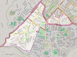
Gardens is an affluent inner-city suburb of Cape Town located just to the south of the city centre located in the higher elevations of the "City Bowl" and directly beneath Table Mountain and Lion's Head. It is home to several national museums such as Iziko South African National Gallery and the Iziko South African Museum. The University of Cape Town also houses its Fine Arts department in the suburb, at Michaelis School of Fine Art. Company's Garden, South Africa's oldest garden, a public park and heritage site is a focal point of the suburb. The area is also home to the oldest synagogue in Southern Africa, the Old Shul and its successor, the Gardens Shul, "The Mother Synagogue of South Africa."
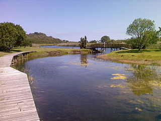
Wilderness National Park, also called the Wilderness Section, is located around the seaside town of Wilderness between the larger towns of George and Knysna, in the Western Cape. It is a protected area of South Africa forming part of the Garden Route National Park.
Welgevonden Game Reserve,, is in the Waterberg District, of the Limpopo, province of South Africa. Welgevonden Game Reserve,, is a 38,200ha game reserve in the Waterberg District, of the Limpopo Province of South Africa.
The Kigio Wildlife Conservancy is a protected Conservancy near Gilgil in the Great Rift Valley of Kenya. It is owned and operated by the local community.

Bwabwata National Park is a protected area in northeastern Namibia that was established in 2007 and covers 6,274 km2 (2,422 sq mi). It was created by merging Caprivi Game Park and Mahango Game Reserve. It is situated in the Zambezi and Kavango East regions, extending along the Caprivi Strip. It is bounded by the Okavango River to the west and the Kwando River to the east. Angola lies to the north and Botswana to the south.

Mudumu is a National Park in Caprivi Region in north-eastern Namibia. The park was established in 1990. It covers an area of 737 square kilometres (285 sq mi). The Kwando River forms the western border with Botswana. Various communal area conservancies and community forests surround Mudumu National Park.
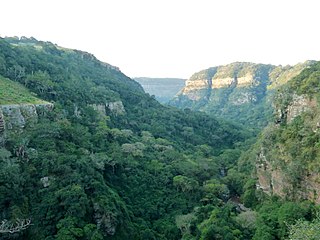
The Krantzkloof Nature Reserve, managed by Ezemvelo KZN Wildlife, conserves 668 ha of the Molweni and Nkutu River gorges that incise the sandstone Kloof plateau in KwaZulu-Natal, South Africa. The reserve conserves coastal scarp forest, sourveld grassland, a cliff face biotope, and aquatic environments along its rivers. Scarp forest is a threatened forest type, protected by South Africa's forests act of 1998, while the grassland is classified as KwaZulu-Natal sandstone sourveld, the most threatened terrestrial habitat in the Durban metropole. The reserve was established in 1950 and was augmented by land donations as late as 1999.
Kloof Nek Road, one of South Africa's oldest roads, was built in 1848 as an access road for the suburban pass with the same name which was used primarily as a look-out post for soldiers and a supply route to Camps Bay. The route starts at Kloof Street on the edge of the city bowl and turns into Camps Bay Road at the end of a mountain pass running between Table Mountain and Lion's Head. Despite being only two kilometers long, it is very steep with an average gradient 1:11. The summit of Kloof Nek Road is a small but complicated intersection that's not clearly visible on approach and often catches motorists unaware. The road's steepness may be a contributor to the regular occurrence of often-fatal accidents on Kloof Nek Road.
Msinsi Community Conservancy is an 8.5-hectare (21-acre) sandstone sourveld grasslands reserve in Kloof, Durban, KwaZulu-Natal, South Africa. The park is managed by the Kloof Conservancy, a community organisation that promotes conservation of natural heritage.
The Waters Meeting Nature Reserve is a forest nature reserve near Bathurst in the Eastern Cape, South Africa. The reserve covers 4,054.89 ha, divided into two sections. The Kowie River borders the western edge of the reserve and separates it in the upper section with the Buffalo Kloof Protected Environment. The lower section contains the Sarel Hayward Dam.
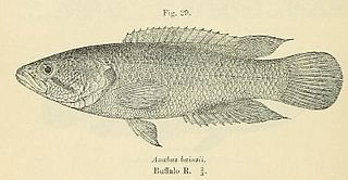
The Blaauwkrantz Nature Reserve is a small protected area near Makhanda (Grahamstown) designated for the purpose of conserving the endangered Eastern Province rocky. Nearby are the Waters Meeting Nature Reserve and Buffalo Kloof Protected Environment. The Blaauwkrantz Pass (R67) runs along the length of the reserve, while the Bloukrans River bisects it horizontally.

The Cycad Nature Reserve is a small reserve near Bathurst for the purpose of conserving the critically endangered cycad Encephalartos latifrons. Near the reserve is the Waters Meeting Nature Reserve and Buffalo Kloof Protected Environment. Part of the Kariega River runs down the western and southern part of the reserve.


