
Mizoram is a state in northeast India, with Aizawl as its seat of government and capital city. The name of the state is derived from "Mizo", the endonym of the native inhabitants, and "Ram", which in the Mizo language means "land." Thus "Mizo-ram" means "land of the Mizos". Within India's northeast region, it is the southernmost landlocked state, sharing borders with three of the Seven Sister States, namely Tripura, Assam and Manipur. The state also shares a 722-kilometre (449 mi) border with the neighbouring countries of Bangladesh and Myanmar.
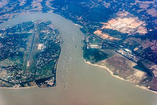
Karnaphuli, or Khawthlangtuipui, is the largest and most important river in Chattogram and the Chattogram Hill Tracts. It is a 667-metre (2,188 ft) wide river in the south-eastern part of Bangladesh. Originating from the Saithah village of Mamit district in Mizoram, India, it flows 270 kilometres (170 mi) southwest through Chattogram Hill Tracts and Chattogram into the Bay of Bengal. Before the Padma, it was the fastest flowing river in Bangladesh. It is said to "represent the drainage system of the whole south-western part of Mizoram." Principal tributaries include the Kawrpui River or Thega River, Tuichawng River and Phairuang River. A large hydroelectric power plant using Karnaphuli river was built in the Kaptai region during the 1960s. The mouth of the river hosts the Port of Chattogram, the largest and busiest seaport of Bangladesh.
The Hmar language or Khawsak ṭawng belongs to the Kukish branch of the Sino-Tibetan family of languages. The speakers of this language use Meitei language as their second language (L2).

Kolasib is a town and headquarters of Kolasib district in Mizoram, India.

Vairengte is a town in the Kolasib district of Mizoram state, India.
Bairabi is a census town in Kolasib district in the state of Mizoram, India.

Lengpui Airport is a domestic airport serving Aizawl, the capital of Mizoram, India. It is located at Lengpui in the Mamit district of the state. The airport is connected by flights to Delhi, Kolkata, Guwahati and Imphal, and is located at a distance of 32 km from Aizawl. Lengpui Airport is the first airport in the country to be built by the Government of Mizoram.

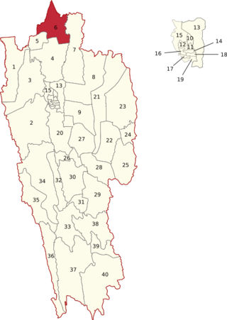
Kolasib district is one of the eleven districts of Mizoram state in India.

Mamit district is one of the eleven districts of Mizoram state in India.
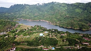
Tuirial dam is an earthfill and gravity dam on the River Sonai near Kolasib in the state of Mizoram in India. The primary purpose of the dam is hydroelectric power production. The Cabinet Committee on Economic Affairs (CCEA) approved the 60 MW Tuirial Hydro Electric Project (THEP) project costing Rs 913 crore in 2010. The project was inaugurated by Prime Minister Narendra Modi on 16 December 2017.
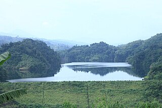
Serlui B dam, is an earthfill and gravity dam on the Serlui river 12 km from Bilkhawthlir Village near the Kolasib district in the state of Mizoram in India.

The Serlui is a river of Mizoram, northeastern India. It flows through Kolasib district and is impounded by the Serlui B Dam.
Bairabi Dam is a proposed 80 MW dam on the Tlawng river near Bairabi Village in Kolasib district in the state of Mizoram in India.
Mizoram is a land of rolling hills, valleys, rivers and lakes in Northeast India. As many as 21 major hills ranges or peaks of different heights run through the length and breadth of the state, with plains scattered here and there. The average height of the hills to the west of the state are about 1,000 metres. These gradually rise up to 1,300 metres to the east. Some areas, however, have higher ranges which go up to a height of over 2,000 metres.
Government Kolasib College is an undergraduate college of Mizoram state in India located at Kolasib. It is a coeducation institute governed by the Directorate of Higher & Technical Education, Education & Human Resources Department, Government of Mizoram. It is affiliated to the Mizoram University, a central university under University Grants Commission of India. Established in 1978, it is nationally recognised under 2(f) and 12-B of the U.G.C. Act, 1956.

Bilkhawthlir is a town in Kolasib District, Mizoram, India.

The following outline is provided as an overview of and topical guide to Mizoram:

Kolasib Legislative Assembly constituency is one of the 40 Legislative Assembly constituencies of Mizoram state in India.
Serlui Legislative Assembly constituency is one of the 40 Legislative Assembly constituencies of Mizoram state in India.

