
The Kalahari Desert is a large semi-arid sandy savanna in Southern Africa extending for 900,000 square kilometres (350,000 sq mi), covering much of Botswana, as well as parts of Namibia and South Africa.

At 824,292 km2 (318,261 sq mi), Namibia is the world's thirty-fourth largest country. After Mongolia, Namibia is the second least densely populated country in the world. Namibia got its name from the Namib desert that stretches along the coast of the Atlantic. It is also known for its wildlife.
This article deals with the system of transport in Namibia, both public and private.
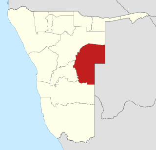
Omaheke is one of the fourteen regions of Namibia, the least populous region. Its capital is Gobabis. It lies in eastern Namibia on the border with Botswana and is the western extension of the Kalahari Desert. The self-governed villages of Otjinene, Leonardville and Witvlei are situated in the region. As of 2020, Omaheke had 48,594 registered voters.

Gobabis is a town in eastern Namibia. It is the regional capital of the Omaheke Region, and the district capital of the Gobabis electoral constituency. Gobabis is situated 200 km (120 mi) down the B6 motorway from Windhoek to Botswana. The town is 113 km (70 mi) from the Buitepos border post with Botswana, and serves as an important link to South Africa on the tarred Trans-Kalahari Highway. Gobabis is in the heart of the cattle farming area. In fact Gobabis is so proud of its cattle farming that a statue of a large Brahman bull with the inscription "Cattle Country" greets visitors to the town. Gobabis also has its own local airport.

Kang is a village in Kgalagadi District of Botswana. It is situated in the Kalahari Desert and lies on the Trans-Kalahari Highway between Ghanzi in the north and Sekoma in the south. Kang also provides access to the Kgalagadi Transfrontier Park in the south-west and the Central Kalahari Game Reserve in the north-east. The route via Ghanzi takes one to the Namibian border, whilst that to Sekoma leads to Gaborone, the capital of Botswana. The population was 5,985 according to the 2011 census. Kang also falls under the Kgalagadi North constituency whose Member of Parliament is Hon. Talita Monnakgotla. The village is divided into seven wards which are; Gasekgalo, Gamonyemana, Gamotshoto, Gapanyana, Gamoriti, Kaatshwene and Tshwaragano ward. The village is led by a female chief, Kgosi Basadi Seipone who is the daughter to the late former chief Churchill Pego Seipone who died in 2010. The village's key development areas include the Central Roads Depot, Central Transport Organisation, Airstrip/Landing ground, mini Rural Administration Centre/ Service Centre, Botswana Open University Regional Campus, Brigade Centre, Police Station, Health Clinic, Magistrate Court, Department Road Transport Service offices, Wildlife offices, Botswana Power Corporation Offices, Water Utilities Corporation offices, Facility Management offices, Senior Secondary, Junior Secondary School and two primary schools.

The Kalahari Basin, also known as the Kalahari Depression, Okavango Basin or the Makgadikgadi Basin, is an endorheic basin and large lowland area covering approximately 725,293 km2 (280,037 sq mi) — mostly within Botswana and Namibia, but also parts of Angola, South Africa, Zambia, and Zimbabwe. The outstanding physical feature in the basin, and occupying the centre, is the large Kalahari Desert.

Lüderitz Bay or Lüderitzbaai, also known as Angra Pequena, is a bay in the coast of Namibia, Africa. The city of Lüderitz is located at the edge of the bay.

Usakos is a town on the banks of river Khan, 140 kilometres north-east of Swakopmund in the Erongo Region of Namibia. It is located on the B2, the main road between the Walvis Bay and Johannesburg. The town has 5,094 inhabitants.
The Trans-Kalahari Corridor is a paved highway corridor that provides a direct route from the port of Walvis Bay and Windhoek in central Namibia, through Botswana, to Pretoria in Gauteng province in South Africa. It initially cost approximately 850 million Namibian dollars and was officially opened in 1998.

The Kalahari Craton is a craton, an old and stable part of the continental lithosphere, that occupies large portions of South Africa, Botswana, Namibia and Zimbabwe. It consists of two cratons separated by the Limpopo Belt: the larger Kaapvaal Craton to the south and the smaller Zimbabwe Craton to the north. The Namaqua Belt is the southern margin of the Kaapvaal Craton.
Charles Hill is a village in Ghanzi District of Botswana. It is located close to the Namibian border. Charles Hill is the second-largest village in Ghanzi District, with a population of 3,591 in 2011 census.
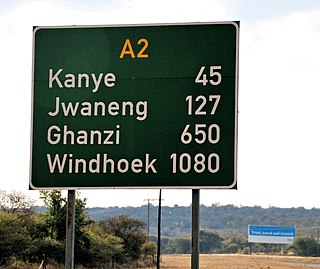
The A2 highway is a road in Botswana running from the Namibian border at Buitepos through Jwaneng, Kanye and Lobatse to the South African border at Pioneer Gate, thus connecting 3 countries.
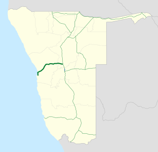
B2 is a major road in Namibia. The highway runs east–west between the major sea port of Walvis Bay and the nation's capital Windhoek.
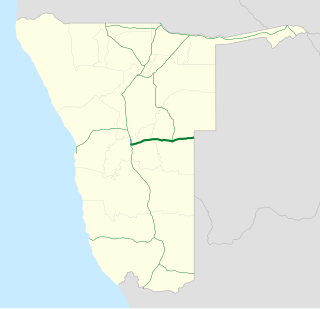
B6 is a national highway of eastern-central Namibia. It is 318 kilometres (198 mi) long and connects the capital Windhoek with the Buitepos border crossing to Botswana. Gobabis, the capital of Omaheke Region, lies on the B6, as do the villages of Seeis, Omitara and Witvlei. Hosea Kutako International Airport is also located on the B6, east of Windhoek.
The Namibian Ports Authority (Namport) is a state owned enterprise established by an act of parliament as the national port authority of Namibia, managing principally the ports of Walvis Bay and Lüderitz, as well as managing a Syncrolift dry dock facility in Walvis Bay. Namport was founded in 1994. Its head office is located in Walvis Bay.

Kalahari Constituency is an electoral constituency in the Omaheke Region of eastern central Namibia. It had 9,234 inhabitants in 2004 and 5,294 registered voters in 2020. The constituency covers the rural area east of Gobabis as well as Gobabis' Nossobville suburb. The constituency office has been inaugurated in 2009 and is located at the Ben-Hur settlement. Kalahari constituency forms part of the border between Namibia and Botswana.

The Government of Namibia allows citizens of specific countries and territories to travel to Namibia for tourism, visiting friends and relatives as well as official purposes for 3 months with an ordinary, diplomatic and service passports without having to obtain a visa. All visitors must have a passport valid for at least 6 months.

The rail service in Namibia is provided by TransNamib. The Namibian rail network consists of 2,687 km of tracks (2017).
The Damara orogeny was part of the Pan-African orogeny. The Damara orogeny occurred late in the creation of Gondwana, at the intersection of the Congo and the Kalahari cratons.

