Burbage, Leicestershire

Last updated

Burbage
Burbage War Memorial - geograph.org.uk - 660582.jpg
Burbage War Memorial
Leicestershire UK location map.svg
Red pog.svg
Burbage
Location within Leicestershire
Population14,568 (2011)
OS grid reference SP443923
District
Shire county
Region
Country England
Sovereign state United Kingdom
Post town HINCKLEY
Postcode district LE10
Dialling code 01455
Police Leicestershire
Fire Leicestershire
Ambulance East Midlands
UK Parliament
List of places
UK
England
Leicestershire
52°31′40″N1°20′54″W / 52.5277°N 1.3483°W / 52.5277; -1.3483
A 1961 1 inch = 1 mile series map. It covers the Hinckley-Nuneaton-Atherstone--Wolvey region. Harts Hill quarry is attached to a railway and in full swing. The coal mines near Griff Lodge Farm and Ansley Hall are in early decline. The mines are now shut and the quarry is (as far as I know) a rubbish-tip. Note the even by then removed railway by Higham Grange and Higham on the Hill. Nueaton Hinkley 1961 OS.jpg
A 1961 1 inch = 1 mile series map. It covers the Hinckley-Nuneaton-Atherstone--Wolvey region. Harts Hill quarry is attached to a railway and in full swing. The coal mines near Griff Lodge Farm and Ansley Hall are in early decline. The mines are now shut and the quarry is (as far as I know) a rubbish-tip. Note the even by then removed railway by Higham Grange and Higham on the Hill.

Burbage is a large village in the Borough of Hinckley and Bosworth in Leicestershire, England. [1] According to the United Kingdom Census 2021 the parish had a population of 16,510, an increase from 14,568 at the 2011 census.

Contents

History

The village's name means 'valley/brook with a fortification'. [2]

Leofric, Earl of Mercia, gave the village of Burbage to Coventry Abbey in 1043. At that time it was valued at two shillings. By the time of the Domesday Book in 1086, its value had risen to £4. There were 1¼ hides of land (around 150 acres (0.61 km2)) with two ploughs. Twenty villagers held two smallholdings, with two slaves and eight ploughs. Burbage also had a meadow, measuring a furlong in length and width (about 40,500 square metres). The village also owned woodland half a league by four furlongs (2.2 square kilometres).

In 1564 the diocesan returns show a population of 57 families within Burbage and six at Sketchley. Burbage, for many centuries a small farming community, remained very thinly populated. In the census of 1801 there were 1098 inhabitants. It was not until the twentieth century that the population exceeded 2000.

During the English Civil War the village's proximity to Hinckley drew it to the attention of raiding parties from the local parliamentary garrisons in north Warwickshire. A list of claims submitted by the constables of Burbage and Sketchley to the Warwickshire county committee, in June, 1646, reveals that Captain Flower’s troop from the Coventry garrison took twenty strikes of provender valued at £1, sent off to Stoney Stanton, and availed themselves of free quarter worth £18.10. Captain Willington's cornet from the Tamworth garrison took a mare, saddle and bridle from John Watkin, while Captain Willington's soldiers took a horse worth £5 from Thomas Bodington.(SP28/161)

Burbage was also the birthplace, in 1608, of John Cook. Cook went on to become Solicitor-General of the Commonwealth of England and lead the prosecution of King Charles I for High Treason, resulting in Charles' execution and, ultimately, his own.

By 1953, the population had risen to 3,983, and by 1958 there were more than 5,000 on the electoral roll; this rapid growth was largely due to the expansion of Sketchley Hill housing estates. In 2001 the population of Burbage was 14,324.

People

The leading barrister and judge Ann Curnow QC was born here, and so was the mathematician R. Cotes (1682-1716).

Burbage today

Burbage is effectively a suburb of the larger urban area of Hinckley and is part of Hinckley and Bosworth borough. The old Burbage village is now a small part of a large parish which also includes Sketchley Village and some large and small residential estates. It is considered by some to be a commuter location for large parts of Leicestershire, Warwickshire and the West Midlands. This is probably due to the fact it is less than a mile from the M69 (which links that M6 to the M1) and the A5.

Burbage has a small library which was threatened with closure in 2015, due to a cost-cutting strategy by the county council. [3] In 2016, a group of community volunteers from the area were successful in submitting plans to take control of the running of the library. The group also gained CIO (charitable incorporated organisation) status and have since made improvements to the library's facilities. [4] [5]

There is a primary school, an infant school, a junior school and a high school. The 1st Britannia Scout Group (which includes Beaver Scout, Cub Scout, Scout and Explorer Scout sections) on Britannia Fields, There is a farmers market every first Saturday of the month running 9:00 am to 1:00 pm.

The nearest railway station is Hinckley which is about 1.5 miles (2.4 km) from Burbage centre, on the boundary between Burbage and Hinckley.

A yearly summer street carnival and fete is organised by the Burbage Carnival Committee, whose purpose is to raise funds to donate to local good causes. This has been a very popular community event and has raised over 1/2 million pounds for good causes. The carnival committee also runs the Burbage Bonfire and Fireworks Display held on Britannia Fields - all to support local charities.

The Freestyle Burbage community events project, a crowdsourced and crowdfunded programme of events organised and run by local residents, was started in 2013 by residents in the Sketchley Hill and Lash Hill area. It folded in 2018 due to lack of support.

The highest rank local football team is called FC Burbage who play at various venues around the village. Mini soccer through to open age and veterans football are teams who play for this large grass root club, founded in 2011 by 3 local dads wanting to provide a safe and fun game for local children. The Club is still Chaired by one of the original 3 founders, with growing team numbers for both boys, girls men and women to all get involved. With over 350+ players this is a large grass roots club.. [6]

Burbage Common and Woods

Burbage Common - geograph.org.uk - 847586.jpg

Burbage Common and Woods are in the northeast corner of the Parish. This is a country park run by Hinckley & Bosworth Borough Council. Its history as a grazing area dates back to at least the Domesday Book of 1086. It is now a 200-acre (0.81 km2) park popular with, amongst others, birdwatchers, walkers and horseriders. It is free to enter and is open dawn to dusk every day. [7]

Related Research Articles

<span class="mw-page-title-main">Midlands</span> Place in England

The Midlands is the central part of England, bordered by Wales, Northern England, Southern England and the North Sea. The Midlands correspond broadly to the early-medieval kingdom of Mercia, and later became important in the Industrial Revolution of the 18th and 19th centuries. They are now split into two official regions, the West Midlands and East Midlands. The Midlands' biggest city, Birmingham, is the second-largest in the United Kingdom. Other important cities include Coventry, Derby, Leicester, Lincoln, Nottingham, Stoke-on-Trent, Wolverhampton, and Worcester.

<span class="mw-page-title-main">Nuneaton</span> Market town in Warwickshire, England

Nuneaton is a market town in the borough of Nuneaton and Bedworth in northern Warwickshire, England, located adjacent to the county border with Leicestershire to the north-east. Nuneaton's population at the 2021 census was 88,813, making it the largest town in Warwickshire. Nuneaton's larger urban area, which also includes the large adjoining villages of Bulkington and Hartshill had a population of 99,372 in the 2021 census.

<span class="mw-page-title-main">Atherstone</span> Market town and civil parish in Warwickshire, England

Atherstone is a market town and civil parish in the North Warwickshire district of Warwickshire, England. In the far north of the county, Atherstone is on the A5 national route, and is adjacent to the border with Leicestershire which is here formed by the River Anker. It is situated between the towns of Tamworth and Nuneaton. Atherstone is the administrative centre of the North Warwickshire district, with the offices of North Warwickshire Borough Council located in the town.

<span class="mw-page-title-main">Hinckley and Bosworth</span> Borough and non-metropolitan district in England

Hinckley and Bosworth is a local government district with borough status in Leicestershire, England. The council is based in Hinckley, the largest town. The borough also includes the town of Earl Shilton and numerous villages and surrounding rural areas. The Bosworth in the borough's name refers to the small market town of Market Bosworth, near which the Battle of Bosworth Field was fought in 1485.

<span class="mw-page-title-main">Hinckley</span> Town in Leicestershire, England

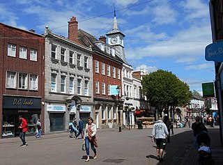
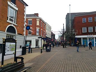
Hinckley is a market town in south-west Leicestershire, England. It is administered by Hinckley and Bosworth Borough Council. Hinckley is the third largest settlement in the administrative county of Leicestershire, after Leicester and Loughborough. Hinckley is about halfway between Leicester and Coventry and borders Nuneaton in Warwickshire. Watling Street forms part of the Hinckley/Nuneaton border.

<span class="mw-page-title-main">Barwell</span> Human settlement in England

Barwell is a civil parish and large village in Leicestershire, England, with a population of 8,750 residents, Increasing to 9,022 at the 2011 census, the name literally translates as "Stream of the Boar" and is said to originate from a boar that used to drink from the well near a brook in Barwell. It was originally known as Borewell, but later became "Barwell", the name in use today. The brook is now called the River Tweed, and is a tributary of the River Trent.

<span class="mw-page-title-main">Dadlington</span> Village in Leicestershire, England

Dadlington is a village and former civil parish, now in the parish of Dadlington and Sutton Cheney, in the Hinckley and Bosworth district, in Leicestershire, England. It is situated between Hinckley, Market Bosworth and Nuneaton. In 1931 the parish had a population of 200.

<span class="mw-page-title-main">Bosworth (UK Parliament constituency)</span> UK Parliament constituency in England since 1885

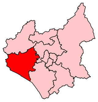
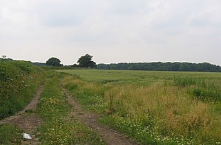
Bosworth is a constituency represented in the House of Commons of the UK Parliament since 2019 by Luke Evans, a Conservative.

<span class="mw-page-title-main">Markfield</span> Human settlement in England

Markfield is a large village in both the National Forest and Charnwood Forest and in the Hinckley and Bosworth district of Leicestershire, England. The settlement dates back to at least the time of the Norman conquest and is mentioned in the Domesday Book under the name Merchenefeld. A variant of this is still used as the name for the village primary school, Mercenfeld. It is to the south-east of Junction 22 of the M1, and to the south of the A50. The highest point in Markfield is shown on OS sheet 129 at 222 metres above sea level. Nearby places are Newtown Linford, Groby, Field Head, and Stanton under Bardon. In the 1841 census its population was recorded at 1,203. In the 2011 census the parish had a population of 5681. In 2012 Hinckley & Bosworth Borough Council published an overview of Markfield conservation area.

Hinckley and Bosworth Borough Council elections are held every four years. Hinckley and Bosworth Borough Council is the local authority for the non-metropolitan district of Hinckley and Bosworth in Leicestershire, England. Since the last boundary changes in 2003, 34 councillors are elected from 16 wards.

<span class="mw-page-title-main">Ratcliffe Culey</span> Human settlement in England

Ratcliffe Culey is a village and former civil parish, now in the parish of Witherley, in the Hinckley and Bosworth district, in Leicestershire, England, near the county boundary with Warwickshire. In 1931 the parish had a population of 184.

<span class="mw-page-title-main">Stoke Golding</span> Human settlement in England

Stoke Golding is a village and civil parish in the Hinckley and Bosworth district of Leicestershire, England, close to the county border with Warwickshire. According to the 2001 census, the total population was 1,721 in just over 700 houses. The population at the 2011 census was 1,684 in 723 households. The village is 16 miles (26 km) from the city of Leicester, about 3 miles (4.8 km) northwest of Hinckley and 4 miles (6.4 km) from Fenny Drayton. The village is bordered on one side by the Ashby Canal, well-used for recreational purposes.

<span class="mw-page-title-main">Higham on the Hill</span> Human settlement in England

Higham on the Hill is a village and civil parish in the Hinckley and Bosworth district of Leicestershire, England. The population at the 2011 census was 840.

<span class="mw-page-title-main">Sheepy</span> Human settlement in England

Sheepy is a civil parish in the Borough of Hinckley and Bosworth in Leicestershire, England. It contains the villages of Sheepy Magna, Sheepy Parva, Sibson, Wellsborough, Upton, Pinwall and Cross Hands—collectively 449 homes. At the 2001 census, the parish had a population of 1,192, including Orton on the Hill but falling slightly to 1,174 at the 2011 census.

<span class="mw-page-title-main">Sibson, Leicestershire</span> Human settlement in England

Sibson is a village and former civil parish, now in the parish of Sheepy, in the Hinckley and Bosworth district, in western Leicestershire, England, close to the border with North Warwickshire. It is situated approximately midway between the towns of Hinckley and Measham, and slightly northeast of Atherstone. In 1931 the parish had a population of 264.

The Britannia Fields are a public open space in Britannia Road, Burbage, Leicestershire.

<span class="mw-page-title-main">Burbage Wood and Aston Firs</span>

Burbage Wood and Aston Firs is a 51.1-hectare (126-acre) biological Site of Special Scientific Interest in Leicestershire.

Hinckley and Bosworth is a proposed constituency of the House of Commons in the UK Parliament. Further to the completion of the 2023 Periodic Review of Westminster constituencies, enacted by the Parliamentary Constituencies Order 2023, it will first be contested at the next general election.

References

  1. OS Explorer Map 232 : Nuneaton & Tamworth: (1:25 000) : ISBN   0 319 46404 0
  2. "Key to English Place-names". kepn.nottingham.ac.uk. Archived from the original on 3 May 2020. Retrieved 16 August 2021.
  3. Hadadi, Samantha (30 January 2015). "Village library is under threat". hinckleytimes. Archived from the original on 21 February 2017. Retrieved 21 February 2017.
  4. Hambridge, Karen (23 June 2016). "New chapter as Burbage Library is handed to volunteers". hinckleytimes. Archived from the original on 21 February 2017. Retrieved 21 February 2017.
  5. Hambridge, Karen (11 December 2016). "Burbage library open after improvements to facilities". hinckleytimes. Archived from the original on 21 February 2017. Retrieved 21 February 2017.
  6. NKF Burbage at the Football Club History Database
  7. "Local Nature Reserves". Natural England. Archived from the original on 24 July 2011. Retrieved 4 February 2011.