Related Research Articles
A drumlin, from the Irish word droimnín, first recorded in 1833, in the classical sense is an elongated hill in the shape of an inverted spoon or half-buried egg formed by glacial ice acting on underlying unconsolidated till or ground moraine. Clusters of drumlins create a landscape which is often described as having a 'basket of eggs topography'.

An aquifer is an underground layer of water-bearing permeable rock, rock fractures or unconsolidated materials. Groundwater can be extracted using a water well. The study of water flow in aquifers and the characterization of aquifers is called hydrogeology. Related terms include aquitard, which is a bed of low permeability along an aquifer, and aquiclude, which is a solid, impermeable area underlying or overlying an aquifer, the pressure of which could create a confined aquifer.

The water table is the upper surface of the zone of saturation. The zone of saturation is where the pores and fractures of the ground are saturated with water.

Groundwater is the water present beneath Earth's surface in soil pore spaces and in the fractures of rock formations. A unit of rock or an unconsolidated deposit is called an aquifer when it can yield a usable quantity of water. The depth at which soil pore spaces or fractures and voids in rock become completely saturated with water is called the water table. Groundwater is recharged from the surface; it may discharge from the surface naturally at springs and seeps, and can form oases or wetlands. Groundwater is also often withdrawn for agricultural, municipal, and industrial use by constructing and operating extraction wells. The study of the distribution and movement of groundwater is hydrogeology, also called groundwater hydrology.

Hydrogeology is the area of geology that deals with the distribution and movement of groundwater in the soil and rocks of the Earth's crust. The terms groundwater hydrology, geohydrology, and hydrogeology are often used interchangeably.

A kettle is a depression/hole in an outwash plain formed by retreating glaciers or draining floodwaters. The kettles are formed as a result of blocks of dead ice left behind by retreating glaciers, which become surrounded by sediment deposited by meltwater streams as there is increased friction. The ice becomes buried in the sediment and when the ice melts, a depression is left called a kettle hole, creating a dimpled appearance on the outwash plain. Lakes often fill these kettles; these are called kettle hole lakes. Another source is the sudden drainage of an ice-dammed lake. When the block melts, the hole it leaves behind is a kettle. As the ice melts, ramparts can form around the edge of the kettle hole. The lakes that fill these holes are seldom more than 10 m (33 ft) deep and eventually become filled with sediment. In acid conditions, a kettle bog may form but in alkaline conditions, it will be kettle peatland.
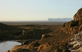
An outwash plain, also called a sandur, sandr or sandar, is a plain formed of glacial sediments deposited by meltwater outwash at the terminus of a glacier. As it flows, the glacier grinds the underlying rock surface and carries the debris along. The meltwater at the snout of the glacier deposits its load of sediment over the outwash plain, with larger boulders being deposited near the terminal moraine, and smaller particles travelling further before being deposited. Sandurs are common in Iceland where geothermal activity accelerates the melting of ice flows and the deposition of sediment by meltwater.
The Illinoian Stage is the name used by Quaternary geologists in North America to designate the period c.191,000 to c.130,000 years ago, during the middle Pleistocene, when sediments comprising the Illinoian Glacial Lobe were deposited. It precedes the Sangamonian Stage and follows the Pre-Illinoian Stage in North America. The Illinoian Stage is defined as the period of geologic time during which the glacial tills and outwash, which comprise the bulk of the Glasford Formation, accumulated to create the Illinoian Glacial Lobe. It occurs at about the same time as the penultimate glacial period.
The Waterloo Moraine is a landform and sediment body that was created as a moraine in the Regional Municipality of Waterloo, in Ontario, Canada. It covers a large portion of the cities of Waterloo and Kitchener and the township of Wilmot, and some parts of the townships of Wellesley and North Dumfries. About 90% of the water supply of the Regional Municipality of Waterloo is derived from groundwater of the Waterloo Moraine aquifer system.

An outwash fan is a fan-shaped body of sediments deposited by braided streams from a melting glacier. Sediment locked within the ice of the glacier, gets transported by the streams of meltwater, and deposits on the outwash plain, at the terminus of the glacier. The outwash, the sediment transported and deposited by the meltwater and that makes up the fan, is usually poorly sorted due to the short distance traveled before being deposited.

A tunnel valley is a U-shaped valley originally cut under the glacial ice near the margin of continental ice sheets such as that now covering Antarctica and formerly covering portions of all continents during past glacial ages. They can be as long as 100 km (62 mi), 4 km (2.5 mi) wide, and 400 m (1,300 ft) deep.

The glacial history of Minnesota is most defined since the onset of the last glacial period, which ended some 10,000 years ago. Within the last million years, most of the Midwestern United States and much of Canada were covered at one time or another with an ice sheet. This continental glacier had a profound effect on the surface features of the area over which it moved. Vast quantities of rock and soil were scraped from the glacial centers to its margins by slowly moving ice and redeposited as drift or till. Much of this drift was dumped into old preglacial river valleys, while some of it was heaped into belts of hills at the margin of the glacier. The chief result of glaciation has been the modification of the preglacial topography by the deposition of drift over the countryside. However, continental glaciers possess great power of erosion and may actually modify the preglacial land surface by scouring and abrading rather than by the deposition of the drift.

The Geology of Kansas encompasses the geologic history of the US state of Kansas and the present-day rock and soil that is exposed there. Rock that crops out in Kansas was formed during the Phanerozoic eon, which consists of three geologic eras: the Paleozoic, Mesozoic and Cenozoic. Paleozoic rocks at the surface in Kansas are primarily from the Mississippian, Pennsylvanian and Permian periods.

Glacial Lake Albany was a prehistoric North American proglacial lake that formed during the end of the Wisconsinan glaciation. It existed between 15,000 and 12,600 years ago and was created when meltwater from a retreating glacier, along with water from rivers such as the Iromohawk, became ice dammed in the Hudson Valley. Organic materials in Lake Albany deposits have been carbon dated to approximately 11,700 years ago. The lake spanned approximately 160 miles (260 km) from present-day Newburgh to Glens Falls.

Overdeepening is a characteristic of basins and valleys eroded by glaciers. An overdeepened valley profile is often eroded to depths which are hundreds of metres below the deepest continuous line along a valley or watercourse. This phenomenon is observed under modern day glaciers, in salt-water fjords and fresh-water lakes remaining after glaciers melt, as well as in tunnel valleys which are partially or totally filled with sediment. When the channel produced by a glacier is filled with debris, the subsurface geomorphic structure is found to be erosionally cut into bedrock and subsequently filled by sediments. These overdeepened cuts into bedrock structures can reach a depth of several hundred metres below the valley floor.
The geology of Maine is part of the broader geology of New England and eastern North America.

The geology of Rhode Island is based on nearly one billion year old igneous crystalline basement rocks formed as part of the microcontinent Avalonia that collided with the supercontinent Gondwana. The region experienced substantial folding associated with its landlocked position during the Alleghanian orogeny mountain building event. The region accumulated sedimentary rocks, including small deposits of coal. The region was covered with thick Atlantic Coastal Plain sediments, with the erosion of the Appalachians and the creation of the Atlantic Ocean throughout the past 200 million years. These surficial sediments and soils were substantially reworked by the Pleistocene glaciations. The state's geology is part of the broader geology of New England.

The geology of Sudan formed primarily in the Precambrian, as igneous and metamorphic crystalline basement rock. Ancient terranes and inliers were intruded with granites, granitoids as well as volcanic rocks. Units of all types were deformed, reactivated, intruded and metamorphosed during the Proterozoic Pan-African orogeny. Dramatic sheet flow erosion prevented almost any sedimentary rocks from forming during the Paleozoic and Mesozoic. From the Mesozoic into the Cenozoic the formation of the Red Sea depression and complex faulting led to massive sediment deposition in some locations and regional volcanism. Sudan has petroleum, chromite, salt, gold, limestone and other natural resources.
The geology of Estonia is the study of rocks, minerals, water, landforms and geologic history in Estonia. The crust is part of the East European Craton and formed beginning in the Paleoproterozoic nearly two billion years ago. Shallow marine environments predominated in Estonia, producing extensive natural resources from organic matter such as oil shale and phosphorite. The Mesozoic and much of the Cenozoic are not well-preserved in the rock record, although the glaciations during the Pleistocene buried deep valleys in sediment, rechanneled streams and left a landscape of extensive lakes and peat bogs.
Groundwater in Nigeria is widely used for domestic, agricultural, and industrial supplies. The Joint Monitoring Programme for Water Supply and Sanitation estimate that in 2018 60% of the total population were dependent on groundwater point sources for their main drinking water source: 73% in rural areas and 45% in urban areas. The cities of Calabar and Port Harcourt are totally dependent on groundwater for their water supply.
References
- ↑ Ohio DNR, Well Construction in a Buried Valley
- ↑ Kehew, Alan E.; Boettger, William M. (Nov–Dec 1986). "Depositional Environments of Buried-Valley Aquifers in North Dakota". Groundwater. 24 (6): 728–734. doi:10.1111/j.1745-6584.1986.tb01688.x.
- ↑ Jorgensen, F; Sandersen, P (2006). "Buried and open tunnel valleys in Denmark - erosion beneath multiple ice sheets". Quaternary Science Reviews . 25 (11–12): 1339–1363. Bibcode:2006QSRv...25.1339J. doi:10.1016/j.quascirev.2005.11.006.
- ↑ Smith, LN (2004). "Late Pleistocene stratigraphy and implications for deglaciation and subglacial processes of the Flathead Lobe of the Cordilleran Ice Sheet, Flathead Valley, Montana, USA". Sedimentary Geology . 165 (3–4): 295–332. Bibcode:2004SedG..165..295S. doi:10.1016/j.sedgeo.2003.11.013.
- ↑ Seyoum, W. , & Eckstein, Y. (2014). Hydraulic relationships between buried valley sediments of the glacial drift and adjacent bedrock formations in northeastern Ohio, USA. Hydrogeology Journal, 22(5), 1193–1206.
- ↑ Metzen, J. (2012). Discovery of an e-w trending Pleistocene buried valley in the German bight, southern North Sea. Quaternary International, 279–280, 325.
- ↑ Oldenborger, G. , Logan, C. , Hinton, M. , Pugin, A. , Sapia, V. , et al. (2016). Bedrock mapping of buried valley networks using seismic reflection and airborne electromagnetic data. Journal of Applied Geophysics, 128, 191–201.
- ↑ Høyer, A. , Jørgensen, F. , Sandersen, P. , Viezzoli, A. , & Møller, I. (2015). 3d geological modelling of a complex buried-valley network delineated from borehole and aem data. Journal of Applied Geophysics, 122, 94–102.
- ↑ He, X. , Sonnenborg, T. , Jørgensen, F. , & Jensen, K. (2017). Modelling a real-world buried valley system with vertical non-stationarity using multiple-point statistics. Hydrogeology Journal, 25(2), 359–370.
- ↑ Dragon, K. (2008). The influence of anthropogenic contamination on the groundwater chemistry of a semi-confined aquifer (the wielkopolska buried valley aquifer, Poland). Water Resources Management, 22(3), 343–355.
- ↑ "Miami Conservation District. (2009). Water in the Great Miami River Watershed". Archived from the original on 2016-11-11. Retrieved 2017-05-08.
- ↑ Buried-valley aquifers in the Canadian prairies: Geology, hydrogeology, and origin 1 1 earth science sector (ess) contribution 20120131. (2012). Canadian Journal of Earth Sciences, 49(9), 987–1004.
- ↑ Kluiving, S. , Aleid Bosch, J. , Ebbing, J. , Mesdag, C. , & Westerhoff, R. (2003). Onshore and offshore seismic and lithostratigraphic analysis of a deeply incised Quaternary buried valley system in the northern Netherlands. Journal of Applied Geophysics, 53(4), 249–271.