Burkburnett, Texas | |
---|---|
Nicknames: Boomtown, U.S.A. | |
Motto: "You're home now!” | |
Coordinates: 34°04′28″N98°34′02″W / 34.07444°N 98.56722°W | |
Country | United States |
State | Texas |
County | Wichita |
Incorporated City of Burkburnett | 1923 |
Government | |
• Type | Commissioner form of government, with a City Manager |
Area | |
• Total | 11.54 sq mi (29.90 km2) |
• Land | 11.54 sq mi (29.90 km2) |
• Water | 0.00 sq mi (0.00 km2) |
Elevation | 1,040 ft (320 m) |
Population (2010) | |
• Total | 10,811 |
• Estimate (2019) [3] | 11,270 |
• Density | 976.35/sq mi (376.97/km2) |
Time zone | UTC-6 (Central (CST)) |
• Summer (DST) | UTC-5 (CDT) |
ZIP code | 76354 |
Area code | 940 |
FIPS code | 48-11368 [4] |
GNIS feature ID | 2409941 [2] |
Website | www |
Burkburnett is a city in Wichita County, Texas, United States. It is part of the Wichita Falls, Texas metropolitan statistical area. Its population was 10,939 at the 2020 census. [5]
Originally settled by ranchers as early as 1856, this community was known by some locals as Nesterville. By 1880, the town had a small store with a population of 132. From 1882 until 1903, a post office operated there under the designation Gilbert, named after the North Texas pioneer Mabel Gilbert. In 1906, a nearby wealthy rancher named Samuel Burk Burnett sold more than 16,000 acres (65 km2) of his land in northern Wichita County to a group of investors who were seeking to extend into the wheat-growing area of Western Oklahoma the Wichita Falls and Northwestern Railway, one of the Frank Kell/Joseph A. Kemp properties based in Wichita Falls. [6]
Within Burnett's former land near the railroad, lots were auctioned off the following year and a post office was established. The town was named Burkburnett by U.S. President Theodore Roosevelt, who visited the area for a wolf hunt that was hosted by the wealthy rancher Burnett. [7] In 1912, oil was discovered west of the town, attracting thousands to the area, and by 1918, approximately 20,000 people had settled around the oilfield. This part of the town's history was chronicled in the film, Boom Town with Clark Gable and Spencer Tracy. The Great Depression had a negative impact on the town's population, which was boosted again in 1941 as Sheppard Air Force Base was established nearby.
According to the United States Census Bureau, Burkburnett has a total area of 9.5 square miles (24.6 km2), all land.
The climate in this area is characterized by hot, humid summers and generally mild to cool winters. According to the Köppen climate classification, Burkburnett has a humid subtropical climate, Cfa on climate maps. [8]
Climate data for Burkburnett, Texas | |||||||||||||
---|---|---|---|---|---|---|---|---|---|---|---|---|---|
Month | Jan | Feb | Mar | Apr | May | Jun | Jul | Aug | Sep | Oct | Nov | Dec | Year |
Record high °F (°C) | 89 (32) | 93 (34) | 100 (38) | 103 (39) | 110 (43) | 117 (47) | 114 (46) | 113 (45) | 111 (44) | 102 (39) | 89 (32) | 88 (31) | 117 (47) |
Mean daily maximum °F (°C) | 54 (12) | 58 (14) | 67 (19) | 76 (24) | 84 (29) | 91 (33) | 97 (36) | 97 (36) | 88 (31) | 77 (25) | 65 (18) | 55 (13) | 76 (24) |
Daily mean °F (°C) | 42 (6) | 46 (8) | 54 (12) | 63 (17) | 72 (22) | 80 (27) | 85 (29) | 84 (29) | 76 (24) | 65 (18) | 53 (12) | 43 (6) | 64 (18) |
Mean daily minimum °F (°C) | 30 (−1) | 34 (1) | 41 (5) | 49 (9) | 60 (16) | 68 (20) | 72 (22) | 71 (22) | 63 (17) | 52 (11) | 40 (4) | 31 (−1) | 51 (10) |
Record low °F (°C) | −12 (−24) | −8 (−22) | 6 (−14) | 24 (−4) | 36 (2) | 50 (10) | 54 (12) | 53 (12) | 38 (3) | 21 (−6) | 14 (−10) | −7 (−22) | −12 (−24) |
Source: [9] |
Census | Pop. | Note | %± |
---|---|---|---|
1920 | 5,300 | — | |
1930 | 3,281 | −38.1% | |
1940 | 2,814 | −14.2% | |
1950 | 4,555 | 61.9% | |
1960 | 7,621 | 67.3% | |
1970 | 9,230 | 21.1% | |
1980 | 10,668 | 15.6% | |
1990 | 10,145 | −4.9% | |
2000 | 10,927 | 7.7% | |
2010 | 10,811 | −1.1% | |
2020 | 10,939 | 1.2% | |
U.S. Decennial Census [10] |
Race | Number | Percentage |
---|---|---|
White (NH) | 8,518 | 77.87% |
Black or African American (NH) | 338 | 3.09% |
Native American or Alaska Native (NH) | 95 | 0.87% |
Asian (NH) | 85 | 0.78% |
Pacific Islander (NH) | 5 | 0.05% |
Some Other Race (NH) | 28 | 0.26% |
Mixed/Multi-Racial (NH) | 639 | 5.84% |
Hispanic or Latino | 1,231 | 11.25% |
Total | 10,939 |
As of the 2020 United States census, there were 10,939 people, 4,725 households, and 3,330 families residing in the city.
The city of Burkburnett is a home-rule municipality. The governing body is composed of seven city commissioners who are elected by the voters at-large, rather than by district. The commissioners serve staggered, two-year terms, with four elected during even-numbered years and three elected during odd-numbered years. The commissioners are charged with electing the mayor from among the city commissioners, and appointing or reappointing the city manager. The mayor is the traditional public figurehead of the city, while the city manager is responsible for the day-to-day operations within the city government.
The City of Burkburnett is served by the Burkburnett Independent School District. [13] The school district operates three elementary schools: I.C. Evans Elementary, John G. Tower Elementary, and Overton Ray Elementary, Burkburnett Middle School, and Burkburnett High School. I.C. Evans houses the Burkburnett Head Start program. John G. Tower is located in Wichita Falls, minutes from Sheppard AFB. The mascot for all Burkburnett schools is Bulldogs.
Skip Hicks (1974) American Football Player
Clay County is a county located in the U.S. state of Texas. As of the 2020 census, its population was 10,218. The county seat is Henrietta. The county was founded in 1857 and later organized in 1860. It is named in honor of Henry Clay, famous American statesman, Kentucky Senator and United States Secretary of State.
Wichita County is a county located in the U.S. state of Texas. As of the 2020 census, its population was 129,350. The county seat is Wichita Falls. The county was created in 1858 and organized in 1882. Wichita County is part of the Wichita Falls, Texas, TX metropolitan statistical area.
Archer City is a city in and the county seat of Archer County, Texas, United States. The city lies at the junction of State Highway 79 and State Highway 25. It is located 25 miles (40 km) south of Wichita Falls, and is part of the Wichita Falls metropolitan statistical area. Its population was 1,834 at the 2010 census.
Holliday is a city in Archer County, Texas, United States. It is part of the Wichita Falls, Texas Metropolitan Statistical Area. The population was 1,758 at the 2010 census. The town is named for nearby Holliday Creek, named in turn for John Holliday, a member of a Republic of Texas military expedition.
Seymour is a city in and the county seat of Baylor County, Texas, United States. Its population was 2,575 as of the 2020 Census.
Alto is a town in Cherokee County, Texas, United States. With a population of 1,027 at the 2020 U.S. census, Alto is the closest municipality to the Caddo Mounds State Historic Site, an archaeological site dating back to 800 BC, featuring a prehistoric village and ceremonial center.
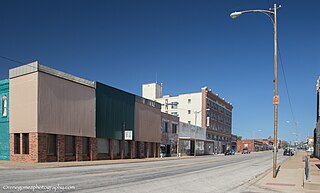
Henrietta is a city in and the county seat of Clay County, Texas, United States. It is part of the Wichita Falls metropolitan statistical area. The population was 3,111 at the 2020 census, a decline of 30 from the 2010 tabulation of 3,141.
Wellington is a city and county seat of Collingsworth County, Texas, United States. The population was 2,189 at the 2010 census.
Ranger is a city in Eastland County, Texas, United States. Its population was 2,468 at the 2010 census. Ranger College, a community college, is the second-largest employer in the community.
Red Oak is a city in Ellis County, Texas, United States. It is part of the Dallas–Fort Worth metroplex. The population was 10,769 at the 2010 census, up from 4,301 at the 2000 census. The North Central Texas Council of Governments projects that number to grow to 63,329 by the year 2030, as it is on the verge of explosive suburban growth. Red Oak was one of the exterior locations for filming True Stories, directed by David Byrne of Talking Heads and released in 1986.
Crowell is a city in Foard County, Texas, United States. It serves as the county seat, and the population was 948 at the 2010 census, down from 1,141 at the 2000 census.
George West is a city in Live Oak County, Texas, United States, and named for cattle rancher George Washington West. The population was 2,445 at the 2010 census. It is the county seat of Live Oak County. George West was named the "storytelling capital of Texas" in 2005 by the Texas Senate; and it hosts the George West Storyfest, a festival that features storytelling, cowboy poetry, and music. Numerous ranches surround George West.
Dumas is a city and the county seat of Moore County, Texas, United States. The population was 14,501 at the 2020 census. Located approximately 40 miles north of Amarillo, the city is named for its founder, Louis Dumas (1856–1923). Dumas Avenue, the main thoroughfare, is also United States Highways 87 and 287.
Breckenridge is a city and county seat of Stephens County, Texas, Texas, United States. The estimated population was 5,349 as of February 2021. The mayor is Bob Sims.
Westworth Village is a city in Tarrant County, Texas, United States. The population was 2,585 at the 2020 census.
Electra is a city in Wichita County, Texas, United States. It is part of the Wichita Falls metropolitan statistical area. The population was 2,791 at the 2010 census., down from 3,168 in 2000. Electra claims the title of Pump Jack Capital of Texas, a title made official by the state in 2001, and has celebrated an annual Pump Jack Festival since 2002. It was named in honor of Electra Waggoner, an heiress to the Waggoner Ranch. Electra is also known for its Grand Theatre which was refurbished and now a functioning theater.
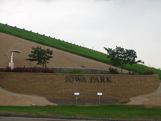
Iowa Park is a city in Wichita County, Texas, United States. It is part of the Wichita Falls, Texas metropolitan statistical area. The population was 6,535 at the 2020 census.
Wichita Falls is a city in and the county seat of Wichita County, Texas, United States. It is the principal city of the Wichita Falls metropolitan statistical area, which encompasses all of Archer, Clay, and Wichita Counties. According to the 2020 census, it had a population of 102,316, making it the 39th-most populous city in Texas.
Cashion Community is a city in Wichita County, Texas, United States. It was incorporated in 2000 and had a population of 348 in 2010. Cashion Community is part of the Wichita Falls, Texas metropolitan statistical area.
The Wichita Falls metropolitan statistical area is a metropolitan area in North Texas that covers three counties – Archer, Clay, and Wichita. As of the 2010 census, the MSA had a population of 151,306.