Burke Canyon

Last updated

Burke Canyon
Cliffs above mine (15187896387).jpg
Cliffs above a mine in Burke Canyon.
USA Idaho location map.svg
Red pog.svg
Burke Canyon
Floor elevation3,768 ft (1,148 m)
Length14 miles (23 km) [1] Northeast–southwest
Width300 feet (91 m) [2]
Geography
Coordinates 47°30′49″N115°51′17″W / 47.51361°N 115.85472°W / 47.51361; -115.85472
Traversed by Idaho State Highway 4
RiversBurke-Canyon Creek

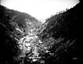
Burke Canyon is the canyon of the Burke-Canyon Creek, which runs through the northernmost part of Shoshone County, Idaho, U.S., within the northeastern Silver Valley. A hotbed for mining in the late-nineteenth and twentieth centuries, Burke Canyon now contains several ghost towns and remnants of former communities along Idaho State Highway 4, which runs northeast through the narrow canyon to the Montana border.

Contents

Burke Canyon takes its name from the town of Burke; settlers arrived in the canyon in 1884 after silver, lead, and zinc were found in mines throughout. Between 1886 and 1890, numerous mining communities developed in the canyon. Many of the communities in Burke Canyon saw multiple labor disputes, namely the Coeur d'Alene labor strike of 1892 and the confrontation of 1899, which resulted in violent conflict between miners and mine owners.

Populations throughout the canyon's towns dwindled in the late-twentieth century after a series of natural disasters and mine closures, and the last active mine in the canyon was closed in 1991, leaving the majority of the communities unpopulated. The Environment Protection Agency includes Burke Canyon as part of the Coeur d'Alene basin's Superfund sites due to hard metal and waste contamination of Burke-Canyon Creek.

History

Settlement

Gold was initially discovered in the early 1860s in the mountains to the north of the Snake River basin, which gave way to a large influx of prospectors. [3] Silver, copper, and other minerals were subsequently discovered. Idaho experienced boom after boom, and mining towns arose overnight, boomed, and then disappeared as the miners left for the latest rush. In 1884, miners discovered significant amounts of silver, zinc, and lead at the Tiger Mine in Burke Canyon. The Tiger Mine was sold to S.S. Glidden for $35,000. [4]

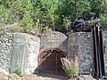
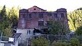
In 1887, Glidden began construction on a three-foot-wide railway to transport hardrock ore out of the Tiger Mine. Meanwhile, a buildup of 100,000 pounds (45,000 kg) of ore had accumulated from the various mines in the canyon, leading to the establishment of the Canyon Creek Railroad, which had its first shipment to Wallace on December 12, 1887. [4] The establishment of the railroad coincided with that of the town of Burke, from which the canyon takes its name. Burke was the largest mining community in the canyon, with a peak population of 1,400 in 1910. [lower-alpha 1] The community of Gem, just south of Burke, had been established in 1886. Both Gem and Burke attracted various miners as well as a large number of Swedish immigrants. [6]

By 1903, Burke Canyon was the most developed mining region in the Coeur d'Alene Mountains and was home to seven dividend-paying mines: the Gem of the Mountains, Frisco, Mammoth, Standard, Hecla, Tiger-Poorman and Hercules mines. [7]

Civil unrest and natural disasters

Frisco Mill before and after July 11, 1892 explosion Frisco Mill before and after explosion.jpg
Frisco Mill before and after July 11, 1892 explosion

On July 10, 1892, miners called a strike which developed into a shooting war between union miners and company guards. The first shots fired were exchanged at the Frisco mine in the early morning hours of July 11. The gunfire ignited a stock of dynamite in the Frisco Mill, causing the four-story mill to explode and kill six people. [lower-alpha 2] [8] The violence soon spilled over into the community of Gem. From there, union miners who had successfully shut down both the Frisco and the Gem mines travelled west, to the Bunker Hill mining complex near Wardner, and closed down that facility as well. The Idaho National Guard and federal troops were dispatched to the area. [9] [10] The incident marked the first violent confrontation between the workers of the mines and their owners. [8] Hostilities would erupt at the Bunker Hill facility once again in 1899. [11] In both disputes, issues included pay, hours of work, the right of miners to belong to the union, and the mine owners' use of informants and undercover agents. [8] Violence committed by union miners was answered with a brutal response in 1892 and in 1899.

Burke Canyon was the site of several natural disasters as well. Two major avalanches struck the canyon in the twentieth century: one on February 4, 1890, which killed three; and another in February 1910, which buried and killed twenty-five people. [12] In the days after the February 1910 avalanche, snow and rock continued to dislodge from the canyon walls, inflicting additional damage on the towns of Burke and Mace, and causing numerous deaths. [12] In August of that year, the Great Fire of 1910 would cause further damage to the communities in the canyon. [12] Three years later, in May 1913, the communities were stricken by heavy rains that resulted in significant floods. [13]

The Northern Pacific railroad considered discontinuing service through the canyon after the depot was damaged in a July 1923 fire. [4] The railroad also cited increased automobile traffic as a reason for discontinuing the line. [4] By 1939, the rail to Burke had been officially closed, and the tracks dismantled. [4]

1980s–present

By the late twentieth century, mining operations in Burke Canyon had slowed considerably. The Hecla Mine in Burke officially ceased operations on June 30, 1983, due to low metal prices. [4] The last mine in Burke officially closed in 1991, and the town and several of the surrounding communities became ghost towns. [12] [14] Around 2010, the Hecla Mining Company has been exploring the potential of exploiting additional resource deposits in the Star mine. As of December 2012, Hecla invested $7 million in rehabilitation and exploration with published estimates suggesting the potential to recover in excess of 25 million ounces of silver from the site with significant zinc and lead deposits also present. [15]

Geography

The structure of Burke Canyon resembles a narrow gulch, roughly 300 feet (90 m) across, with steep cliffs and hills on both sides. [2] The hillsides of the canyon are so steep that the community of Burke only receives around 3 hours of full sunlight during winters. [16]

Climate

Burke Canyon experiences a continental climate, marked by warm summers and cold, snowy winters. [17]

Climate data for 2 Miles ENE of Burke, Idaho (19071967)
MonthJanFebMarAprMayJunJulAugSepOctNovDecYear
Record high °F (°C)48
(9)
63
(17)
65
(18)
83
(28)
86
(30)
98
(37)
95
(35)
99
(37)
92
(33)
78
(26)
62
(17)
50
(10)
99
(37)
Average high °F (°C)28.7
(−1.8)
34.3
(1.3)
39.0
(3.9)
47.7
(8.7)
57.7
(14.3)
65.6
(18.7)
76.3
(24.6)
74.1
(23.4)
65.5
(18.6)
52.0
(11.1)
37.3
(2.9)
30.9
(−0.6)
50.8
(10.4)
Average low °F (°C)15.9
(−8.9)
19.5
(−6.9)
21.6
(−5.8)
27.5
(−2.5)
32.9
(0.5)
39.0
(3.9)
44.2
(6.8)
43.2
(6.2)
38.6
(3.7)
32.2
(0.1)
24.7
(−4.1)
19.1
(−7.2)
29.9
(−1.2)
Record low °F (°C)−24
(−31)
−21
(−29)
−15
(−26)
8
(−13)
13
(−11)
26
(−3)
20
(−7)
23
(−5)
21
(−6)
4
(−16)
−13
(−25)
−26
(−32)
−26
(−32)
Average precipitation inches (mm)6.69
(170)
5.41
(137)
4.92
(125)
3.02
(77)
2.95
(75)
3.32
(84)
1.23
(31)
1.38
(35)
2.54
(65)
4.35
(110)
6.02
(153)
6.18
(157)
48.01
(1,219)
Average snowfall inches (cm)59.9
(152)
45.6
(116)
42.4
(108)
9.5
(24)
3.7
(9.4)
0.5
(1.3)
0.0
(0.0)
0.0
(0.0)
0.2
(0.51)
4.3
(11)
27.7
(70)
48.7
(124)
242.5
(616.21)
Average precipitation days (≥ 0.01 in)201616121312678121718157
Source: Western Regional Climate Center [17]

Communities

In 2002, it was reported that around 300 people lived in or near the canyon. [18] There are numerous communities and former communities located along Burke-Canyon Road in Burke Canyon, though several are now ghost towns. The communities include: [lower-alpha 3]

1907 Geologic map of the Burke Canyon in Idaho, including the locations of Gem, Black Bear, Mace and Burke 1907BurkeCanyonIdaho geologicmap.png
1907 Geologic map of the Burke Canyon in Idaho, including the locations of Gem, Black Bear, Mace and Burke

Environmental concerns

Mining effects

Standard-Mammoth mine entrance near Mace Abandoned mine, Burke, Idaho.jpg
Standard-Mammoth mine entrance near Mace

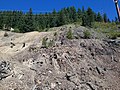
Decades' worth of mining activity resulted in various metals leaching into Canyon Creek, contaminating much of Burke Canyon. Leftover waste rock from mines leached cadmium, lead, arsenic, and zinc into the creekbed. [19] Ecologists found that long stretches of Canyon Creek were entirely uninhabited by fish due to the high levels of metal content in the water. [2] Canyon Creek is considered one of the Coeur d'Alene basin's Superfund sites. [19] The metals leached in Canyon Creek were partially responsible for the contamination of the Coeur d'Alene River, the most heavy-metal contaminated river in the world. [20] In 2010, the United States Environmental Protection Agency (EPA) moved forward with plans to dispose of leftover rock piles and contaminated soil in Burke Canyon. [19]

Various metals also impacted the local water supply of Burke Canyon: After the closure of the last mine in Burke in 1991, residents' water supplies continued to be sourced from pipes that extended into abandoned mine shafts. Consequently, the metal content of Burke's water supply was fifty times above that of federal water quality standards. [2]

In 2001, the EPA offered to buy out residents of Burke Canyon, citing water contamination in Canyon Creek, but residents refused. [2] The following year, the EPA ordered the town of Burke to comply with the Safe Drinking Water Act; however, given the small number of homes within the boundaries of the town, it would have cost each household an estimated $48,000 per year. [2]

Waste disposal

For decades, raw sewage was emptied via pipelines directly into Canyon Creek from the residences in Burke Canyon. [21] By the turn of the twenty-first century, citizens of Burke had continued to dump up to 6,000 US gallons (23,000 L) of raw sewage into Canyon Creek per day. [2] In 2004, the Panhandle Health District (PHD) and Idaho Department of Environmental Equality (DEQ) tested homes in Burke to identify contaminations, finding a total of thirty occupied homes discharging untreated waste into the creek. [2] In 2007, the DEQ sequestered $220,000 in order to help residents install new septic systems to prevent further contamination. [2]

In 2016, the EPA announced its plan to construct a waste repository in lower Burke Canyon in order to alleviate waste accumulation in Wallace. [22] [23] Some residents of the canyon objected to the repository, citing further pollution from diesel trucks used to transport waste in the canyon. [22]

See also

Notes

  1. Per the Population History of Western U.S. Cities and Towns, Burke had the largest population of any community in Burke Canyon, with a peak population of 1,400. [5]
  2. Per the sign at the site of the Frisco Mill along Burke-Canyon Road erected by the Idaho Historical Society, notes six fatalities.
  3. List of communities is adapted from a Google Maps search of Burke Canyon. Communities are list from the northeast to southwest end of the canyon.

Related Research Articles

<span class="mw-page-title-main">ASARCO</span> American integrated energy company

ASARCO is a mining, smelting, and refining company based in Tucson, Arizona, which mines and processes primarily copper. The company has been a subsidiary of Grupo México since 1999.

<span class="mw-page-title-main">Coeur d'Alene people</span> Federally recognized Native American tribe in northern Idaho, United States

The Coeur d'Alene Tribe are a Native American tribe and one of five federally recognized tribes in the state of Idaho.

<span class="mw-page-title-main">Lake Coeur d'Alene</span> Glacial lake in Idaho, US

Lake Coeur d'Alene, officially Coeur d'Alene Lake, is a natural dam-controlled lake in North Idaho, located in the Pacific Northwest region of the United States. At its northern end is the city of Coeur d'Alene. It spans 25 miles (40 km) in length and ranges from 1 to 3 miles (5 km) wide with over 109 miles (175 km) of shoreline.

There were two related incidents between miners and mine owners in the Coeur d'Alene Mining District of North Idaho: the Coeur d'Alene, Idaho labor strike of 1892, and the Coeur d'Alene, Idaho labor confrontation of 1899. This article is a brief overview of both events.

<span class="mw-page-title-main">Coeur d'Alene River</span> River in Idaho

The Coeur d'Alene River flows 37 miles (60 km) from the Silver Valley into Lake Coeur d'Alene in the U.S. state of Idaho. The stream continues out of Lake Coeur d'Alene as the Spokane River.

The history of Idaho is an examination of the human history and social activity within the state of Idaho, one of the United States of America located in the Pacific Northwest area near the west coast of the United States and Canada. Other associated areas include southern Alaska, all of British Columbia, Washington, Oregon, western Montana and northern California and Nevada.

<span class="mw-page-title-main">Hercules silver mine</span>

The Hercules Mine was one of the richest lead/silver mines in the Coeur d'Alene Mountains in Burke, Idaho. It was discovered by Harry L. Day, a bookkeeper and clerk, and Fred Harper, a local prospector. In 1923 the mine owners founded the Day Mines, Inc. company. Other investors in the mine include August Paulsen, Levi Hutton, and May Arkwright Hutton. It eventually became the primary mine of the Hecla Mining Corporation.

<span class="mw-page-title-main">Burke, Idaho</span> Ghost town in Idaho, United States

Burke is a ghost town in Shoshone County, Idaho, United States, established in 1887. Once a thriving silver, lead and zinc mining community, the town saw significant decline in the mid-twentieth century after the closure of several mines.

The Silver Valley is a region in the northwest United States, in the Coeur d'Alene Mountains in northern Idaho. It is noted for its mining heritage, dating back to the 1880s.

<span class="mw-page-title-main">Trail of the Coeur d'Alenes</span>

The Trail of the Coeur d'Alenes is a rail trail in the northwest United States, in northern Idaho. It follows the former Union Pacific Railroad right-of-way from Mullan, a mountain mining town near the Montana border, westward to Plummer, a town on the prairie near the Washington border. Generally following the Coeur d'Alene River, the rail line was abandoned in 1991, and the trail officially opened in March 2004.

<span class="mw-page-title-main">Silver mining in the United States</span>

Silver mining in the United States began on a major scale with the discovery of the Comstock Lode in Nevada in 1858. The industry suffered greatly from the demonetization of silver in 1873 by the Coinage Act of 1873, known pejoratively as the "Crime of 73", but silver mining continues today.

<span class="mw-page-title-main">Hecla Mining</span>


Hecla Mining is a gold, silver and other precious metals mining company based in Coeur d'Alene, Idaho. Founded in 1891, is the second-largest mining company that produces silver in the country. This area is known as the Silver Valley (Idaho). In 1983, this entire area was designated as a Superfund site by the Environmental Protection Agency, because of land, water, and air contamination resulting from a century of mostly unregulated silver and gold mining.

The Bunker Hill Mining Company is a mining company with facilities in Kellogg and Wardner, Idaho.

The Coeur d'Alene, Idaho, labor riot of 1899 was the second of two major labor-management confrontations in the Coeur d'Alene mining district of northern Idaho in the 1890s. Like the first incident seven years earlier, the 1899 confrontation was an attempt by union miners, led by the Western Federation of Miners to unionize non-union mines, and have them pay the higher union wage scale. As with the 1892 strike, the 1899 incident culminated in a dynamite attack that destroyed a non-union mining facility, the burning of multiple homes and outbuildings and two murders, followed by military occupation of the district.

<span class="mw-page-title-main">1892 Coeur d'Alene labor strike</span>

The 1892 Coeur d'Alene labor strike erupted in violence when labor union miners discovered they had been infiltrated by a Pinkerton agent who had routinely provided union information to the mine owners. The response to the labor violence, disastrous for the local miners' union, became the primary motivation for the formation of the Western Federation of Miners (WFM) the following year. The incident marked the first violent confrontation between the workers of the mines and their owners. Labor unrest continued after the 1892 strike, and surfaced again in the labor confrontation of 1899.

<span class="mw-page-title-main">Bunker Hill Mine and Smelting Complex</span>

The Bunker Hill Mine and Smelting Complex was a large smelter located in Kellogg, Idaho, in the Coeur d'Alene Basin. When built, it was the largest smelting facility in the world. It is located in what became known as the Silver Valley of the Coeur d'Alene Basin, an area for a century that was a center of extensive silver and other metal mining and processing. This resulted in extensive contamination of water, land and air, endangering residents including the Coeur d'Alene Tribe, which had traditionally depended on fish from the waterways as part of its subsistence.

Rimini, is a ghost town in Lewis and Clark County, Montana, United States. It is one of the oldest mining districts in the state. It was established when silver lodes were discovered in 1864. Other names for the town were Lewis and Clark, Tenmile, Vaughn, Colorado, and Bear Gulch. It was the site of Camp Rimini.

Idaho v. United States, 533 U.S. 262 (2001), was a United States Supreme Court case in which the Court held that the United States, not the state of Idaho, held title to lands submerged under Lake Coeur d'Alene and the St. Joe River, and that the land was held in trust for the Coeur d'Alene Tribe as part of its reservation, and in recognition of the importance of traditional tribal uses of these areas for basic food and other needs.

<span class="mw-page-title-main">Zinc mining in the United States</span>

Zinc mining in the United States produced 780,000 tonnes of zinc in 2019, making it the world's fourth-largest zinc producer, after China, Australia, and Peru. Most US zinc came from the Red Dog mine in Alaska. The industry employed about 2,500 in mining and milling, and 250 in smelting.

<span class="mw-page-title-main">David P. Bond (author)</span> American writer

David Preston Bond was a newspaper reporter, columnist, and editor based in the American Northwest. He chronicled and supported North Idaho’s mining industry over much of his career. "Bond considered himself a defender of the blue-collar man," one tribute added, "who didn’t hesitate to take on big government and those he considered a threat to their livelihood."

References

  1. "Burke-Canyon Creek Road". Google Maps . Retrieved February 7, 2018.
  2. 1 2 3 4 5 6 7 8 9 "Life in the Canyon: More than a Century of Sewage". Northwest Center for Public Health Practice. University of Washington. October 16, 2009. Archived from the original on July 14, 2016. Retrieved August 26, 2017.
  3. Lee, Lawrence D. "Snake River Gold" (PDF). Idaho Museum of Natural History. Idaho State University: 1–3. Retrieved April 25, 2020.
  4. 1 2 3 4 5 6 Wood, John V. (Spring 2016). "Railroads to Burke" (PDF). Museum of Northern Idaho. pp. 1–8.
  5. Moffatt, Riley (1996). Population History of Western U.S. Cities & Towns, 1850-1990. Lanham: Scarecrow Press. p. 91. ISBN   978-0-810-83033-2.
  6. Atteberry, Jennifer Eastman (2007). Up in the Rocky Mountains: Writing the Swedish Immigrant Experience. University of Minnesota Press. p. 219. ISBN   978-1-452-91299-8.
  7. Brice, J. L. (September–October 1903). "The Coeur d'Alenes, Idaho". Mining. 12 (3–4): 39–99. Retrieved April 25, 2020.
  8. 1 2 3 Clark, Earl (August 1971). "Shoot-out in Burke Canyon". American Heritage . 22 (5).
  9. Rayback 1966, pp. 169–70.
  10. Carlson 1983, p. 50.
  11. Carlson 1983, pp. 53–6.
  12. 1 2 3 4 Albright, Syd (September 29, 2013). "Silver, snow and tears in Burke ghost town". The Coeur d'Alene Press. History Corner. Archived from the original on August 27, 2017.
  13. Weeks 2015, p. 168.
  14. Weeks 2015, p. 169.
  15. "Hecla Mining - 2012 Exploration Report - Silver Valley". Hecla Mining Company Company Website. Hecla Mining Company. Archived from the original on October 13, 2014.
  16. National Research Council, et al. 2006, p. 26.
  17. 1 2 "Burke 2 ENE, Idaho - Climate Summary - Temperature". Western Regional Climate Center. Retrieved July 1, 2012.
  18. Shors, Benjamin (July 21, 2002). "EPA is a bad word in Burke". The Spokesman-Review. Archived from the original on January 11, 2015. Retrieved August 6, 2010.
  19. 1 2 3 Kramer, Becky (June 16, 2010). "EPA plans next stage of Superfund cleanup". The Spokesman-Review. Retrieved August 27, 2017.
  20. "Idaho Yesterdays". 43–5. Idaho Historical Society. 1999: 11–12.{{cite journal}}: Cite journal requires |journal= (help)
  21. Hoffman, Todd. "Canyon Creek". North Idaho Rivers and Creeks. Retrieved July 1, 2017.
  22. 1 2 "Lower Burke Canyon Repository Waste Management: EPA Response to Community Input" (PDF). United States Environmental Protection Agency. July 2016. Retrieved August 26, 2017.
  23. McDonald, Josh (April 12, 2017). "EPA Seeks Public Comment on Repository Project". Shoshone News Press. pp. 1–8. Retrieved August 25, 2017.

Works cited

47°30′49″N115°51′17″W / 47.51361°N 115.85472°W / 47.51361; -115.85472