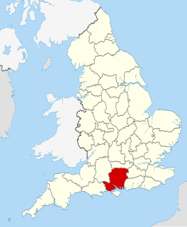
Lasham is a village and civil parish in the East Hampshire district of Hampshire, England. It is 3.4 miles (5.5 km) northwest of Alton and 1.2 miles (1.9 km) north of Bentworth, just off the A339 road. The parish covers an area of 1,797 acres (727 ha) and has an average elevation of 560 feet (170 m) above sea level. The nearest railway station is Alton, 3.5 miles (5.6 km) southeast of the village. Lasham formerly had its own railway station, Bentworth and Lasham, on the Basingstoke and Alton Light Railway until the line's closure in 1936. According to the 2011 census, the village had a population of 176.

Beech is a village and civil parish in the East Hampshire district of Hampshire, England. It lies 2 miles (3 km) west of Alton, just west of the A339 road.

Binsted is a village and large civil parish in the East Hampshire district of Hampshire, England. It lies about 4.1 miles (6.6 km) east of Alton, its nearest town. The parish is one of the largest in northern Hampshire and covers almost 7,000 acres (2,800 ha). It contains two villages, Bucks Horn Oak and Holt Pound, as well as two hamlets, Wyck and Wheatley. The parish also covers the entirety of the Alice Holt Forest, a royal forest situated near the border with Surrey. The nearest railway station is 1.8 miles (2.9 km) northeast of the village, at Bentley. According to the 2011 census, the parish had a population of 1,817 people.

Shalden is a village and civil parish in the East Hampshire district of Hampshire, England. It is 2.3 miles (3.7 km) northwest of Alton and 1.9 miles (3.1 km) northeast of Bentworth, just off the A339 road. The parish covers an area of 1,536 acres (622 ha) and has an average elevation of 600 feet (180 m) above sea level. The nearest railway station is Alton, 2.5 miles (4.0 km) southeast of the village. According to the 2011 census, it had a population of 435.

Medstead is a village and civil parish in the East Hampshire district of Hampshire, England. Its nearest town is Alton, which lies 4.3 miles (6.9 km) northeast of the village. According to the 2011 census, the village had a population of 2,036 people. The parish covers an area of 1,536 acres (622 ha) and has an average elevation of approximately 600 feet (180 m) above sea level. One of the county's high points at 716 feet (218 m), King's Hill, runs through Medstead and Bentworth.

Hartley Mauditt is an abandoned village in the East Hampshire district of Hampshire, England. It is 1.2 miles (1.9 km) south of the village of East Worldham, and 2.6 miles (4.2 km) southeast of Alton, just east of the B3006 road. It is in the civil parish of Worldham. The nearest railway station is 2.5 miles (4.0 km) northwest of the village, at Alton.

Lower Wield is a village in the East Hampshire district of Hampshire, England. It is in the civil parish of Wield. It is 1.8 miles (2.9 km) west of the village of Bentworth, 5.2 miles (8.4 km) west of Alton. The nearest railway station is Alton, 5.2 miles (8.4 km) east of the village.
Bradley is a small village and civil parish in the Basingstoke and Deane district of Hampshire, England. Its nearest town is Alton, which lies 5.4 miles (8.7 km) southeast from the village, although Basingstoke lies 6.6 miles (10.6 km) to the north. According to the 2011 census, the village had a population of 202 people. The parish covers an area of 975 acres (395 ha), of which 149 acres (60 ha) is woodland and its highest point is 170 metres (560 ft) above sea level. It contains no hamlets.

Thedden is a hamlet in the large civil parish of Bentworth in Hampshire, England, about 2 km south east of the centre of Bentworth village. It is in the civil parish of Old Basing. Its nearest town is Alton, about 3.5 miles (5.1 km) east of Thedden.

Wivelrod is a hamlet in the large civil parish of Bentworth in Hampshire, England. The nearest town is Alton, about 2.8 miles (4.5 km) to the east. At a spot height of 712 feet (217 m), it is one of the highest settlements in Hampshire.
Ashley is a hamlet in the large civil parish of Bentworth in the East Hampshire district of Hampshire, England. Its nearest town is Alton, which lies approximately 4.3 miles to the east.
Holt End is a hamlet in the large civil parish of Bentworth in Hampshire, England, between Bentworth and Medstead. The nearest town is Alton, which lies approximately 4 miles (6.4 km) north-east from the hamlet.

Hall Place is a manor house in the civil parish of Bentworth in Hampshire, England. It is about 300 metres (980 ft) southwest of St Mary's Church and 3.6 miles (5.8 km) northwest of Alton, the nearest town. Built in the early 14th century, it is a Grade II listed medieval hall house, known by various names through the centuries. It is 0.5 miles (0.80 km) from the current Bentworth Hall that was built in 1832.
Hattingley is a small hamlet in the East Hampshire district of Hampshire, England. It is 5 miles (8.0 km) southwest of Alton, just off the A31 road. It was once in the large civil parish of neighbouring Bentworth, however it is now situated in Medstead.

Tickley is a small hamlet in the large civil parish of Bentworth in Hampshire, England. It is considered a part of neighbouring Burkham which is situated 1.2 miles (1.9 km) away; however, it is an individual settlement.
New Copse is a hamlet in the large civil parish of Bentworth in Hampshire, England. The nearest town is Alton, which lies approximately 3.7 miles (6.0 km) to the northeast. The hamlet is often confused with neighbouring Holt End, which also lies in Bentworth.
Gaston Grange is a large country manor situated in the hamlet of Holt End in the large parish of Bentworth, Hampshire. It is about 1.1 miles (1.8 km) southwest of the centre of Bentworth and about 4.1 miles (6.6 km) west of Alton, its nearest town. The manor lies west of the Bentworth-Medstead road towards Upper Wield, south of Gaston Wood.