Related Research Articles

The Excelsior District is a neighborhood in San Francisco, California.

Crocker-Amazon is a neighborhood in San Francisco that borders the Excelsior District. Crocker-Amazon covers the area south of Mission Street and Geneva Avenue, extending toward suburban Daly City. The neighborhood is adjacent to Crocker-Amazon Park, named after the Charles Crocker land holdings that once made up the area, and Amazon Avenue in the Excelsior. The winding streets of the neighborhood straddle the border between San Francisco and Daly City and largely blend in with the adjacent Daly City neighborhoods of Crocker and Southern Hills.

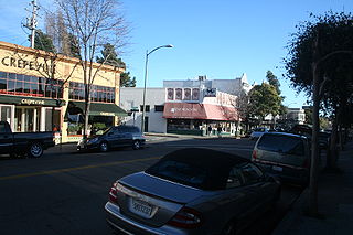
The Piedmont Avenue neighborhood is a residential and commercial district in the North Oakland region of Oakland, California. It is named for Piedmont Avenue, a commercial street known for dining and retail. The neighborhood is roughly bounded by Temescal and Broadway on the west, Oakland Avenue and the City of Piedmont on the east, the Mountain View Cemetery on the north, and the MacArthur Freeway section of Interstate 580 on the south.

Grand Lake, or the Grand Lake District, is a neighborhood in Oakland, California, United States. The neighborhood is located in the northeast corner of Lake Merritt, where Grand Avenue and Lakeshore Avenue pass under Interstate 580. It borders Adams Point to the west, Trestle Glen/Crocker Highlands to the east, and the city of Piedmont to the north. It lies at an elevation of 52 feet.
Rockridge is a residential neighborhood and commercial district in Oakland, California. Rockridge is generally defined as the area east of Telegraph Avenue, south of the Berkeley city limits, west of the Oakland hills and north of the intersection of Pleasant Valley Avenue/51st Street and Broadway. Rockridge was listed by Money Magazine in 2002 as one of the "best places to live".

High Point Terrace is a neighborhood located in the heart of the city of Memphis, Tennessee. The High Point Terrace Historic District is listed on the National Register of Historic Places.
Adams Point is a neighborhood of Oakland, California. It is located on the northern shore of Lake Merritt, directly adjacent to Downtown Oakland and the Grand Lake district. It is a triangle bounded by Grand Avenue on the south, Harrison Street on the northwest, and the MacArthur Freeway on the northeast. It lies at an elevation of 79 feet. Neighborhood landmarks include the Veteran's Memorial Building, the Earl Warren House, the art deco Bellevue-Staten Building, Lakeside Park, one of Oakland's larger parks, and Children's Fairyland, which is in the park.

Maxwell Park is a neighborhood in Oakland, California located in the foothills of the city. It is geographically bordered by MacArthur Boulevard, High Street, Trask Street, Foothill Boulevard, and 55th Avenue and is adjacent to Mills College, I-580, Brookdale Park, and the Fairfax neighborhood. It lies at an elevation of from 138 feet to its highest point of 266 feet on Knowland Ave.

The Claremont district is a neighborhood straddling the city limits of Oakland and Berkeley in the East Bay section of the San Francisco Bay Area in California, United States. The main thoroughfares are Claremont and Ashby Avenues.
Glenview is a neighborhood in Oakland, California developed in the early decades of the 20th century, mostly with mid-sized 2 and 3-bedroom craftsman bungalows. The neighborhood lies in the Oakland foothills, bordering Dimond Park on the eastern side of the district, and Park Boulevard on the northwestern side. The upper portion of the neighborhood sits on the west side of Park Boulevard and is bordered by the Trestle Glen neighborhood as well as the City of Piedmont. Park Boulevard, as the neighborhood spine, also serves as the local shopping node, with a number of convenience shops and several restaurants stretching a few blocks. To the south, the neighborhood is delimited by MacArthur Blvd and the I-580 freeway.
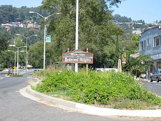
Redwood Heights is a mostly middle-class and highly diverse residential neighborhood in the hills of East Oakland, California. It is centered on Redwood Road, which was once a logging road. Currently, Redwood Road is the designation for 35th Avenue starting about a mile north of MacArthur Boulevard between Victor Avenue and the Warren Freeway. It includes Redwood Heights Elementary School Of the 2 Redwood trees on the school premises. One was planted in 1963 in remembrance of John F Kennedy. And a recreation center that doubles as an after-school daycare. It lies at an elevation of 476 feet.
College Terrace is a neighborhood in the city of Palo Alto, California, adjacent to Stanford University.

Outer Mission is a small residential neighborhood on the south edge of San Francisco, bounded by Geneva Avenue, Interstate 280, Mission Street, and the city of Daly City. It is bordered by the Mission Terrace, Crocker-Amazon, and Ingleside, and touches Excelsior. The Muni streetcar historic "car barn" is at the northern corner of this neighborhood. Cayuga Park is located in this neighborhood. The Cayuga Improvement Association (CIA) covers the area bounded by Interstate 280, Mission Street, Sickles and Onondaga. Some folks have attempted to define "Cayuga Terrace" as a subset neighborhood of the larger Mission Terrace neighborhood, but maps show Geneva Avenue as the cutoff.

Shaw is a neighborhood in St. Louis, Missouri. It is bordered on the North by Interstate 44, the east by S. Grand Blvd, the west by Tower Grove Ave and the Missouri Botanical Gardens, and the south by Tower Grove Park. The Shaw Neighborhood is a local historic district whose historic structure and character is protected by ordinance.
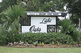
Lake Terrace/Lake Oaks is a neighborhood of the city of New Orleans, Louisiana. A sub-district of the city's Gentilly District, its boundaries as defined by the City Planning Commission are: Lake Pontchartrain to the north; the Industrial Canal to the east; Leon C. Simon Drive, Elysian Fields Avenue, New York Street, the London Avenue Canal, and Allen Toussaint Boulevard to the south; and Bayou St. John to the west. The neighborhood comprises the Lake Terrace and Lake Oaks subdivisions, the principal campus of the University of New Orleans, and the University of New Orleans Research & Technology Park — all built on land reclaimed from Lake Pontchartrain.
Thousand Oaks is a neighborhood of Berkeley in Alameda County, California. Located at the base of the Berkeley Hills, it lies at an elevation of 239 feet.
Burlingame's Historic Willborough neighborhood, located in Burlingame Terrace, is a block-long strip of early 20th century Tudor revival homes. Willborough Road and Willborough Place are located between Oak Grove Road and Palm Drive, a 10-minute walk southeast to downtown Burlingame Ave or 12-minute walk northwest to downtown Broadway Ave. Willborough Road and Willborough Place connect up with Neuchatel Avenue.
Ingleside Terraces is an affluent residential neighborhood of approximately 750 detached homes built at the former location of the Ingleside Racetrack in the southwestern part of San Francisco. It is adjacent to the Balboa Terrace, Ingleside, Merced Heights and Lakeside neighborhoods, and is bordered by Ocean Avenue to the north, Ashton Avenue to the east, Holloway Avenue to the south and Junipero Serra Boulevard to the west. The main local event that occurs is the Annual Sundial Park Picnic, in which the local residents host bicycle, chariot, and wagon racing. There is a large sundial located on Entrada Court, surrounded by the oval-shaped Urbano Drive, which was once a horse race track. Ingleside Terraces is one of nine master-planned residence parks in San Francisco.
References
- ↑ Bromfield, D. Map of Burlingame Terrace. Surveyed October 1905.
- ↑ "Archives Research" Burlingame Historical Society
- ↑ Lyon & Hoag. Ten Facts About Burlingame Terrace. Date unknown (1905?)