Burlington Bay James N. Allan Skyway

Last updated

Burlington Bay James N. Allan Skyway
Burlington Bay James N. Allan Skyway 2004.jpg
The Burlington Bay James N. Allan Skyway, taken in July 2004. The 1958 steel arch span carries QEW Toronto-bound traffic, and is in front of the 1985 concrete span, which carries Niagara-bound traffic. In the background is the Hamilton Harbour.
Coordinates 43°17′58″N79°47′53″W / 43.29945°N 79.79799°W / 43.29945; -79.79799
Carries8 lanes of Ontario QEW crown.svg Queen Elizabeth Way
Crosses Hamilton Harbour
Locale Hamilton, Ontario and Burlington, Ontario
Other name(s)Burlington Skyway
OwnerGovernment of Ontario
Maintained by Ontario Ministry of Transportation
Characteristics
Designsteel through arch bridge - 1958 span
Concrete box girder - 1985 span
Total length2,560 metres (8,400 ft) - 1958 span
2,215 metres (7,267 ft) - 1985 span
Width30 metres (98 ft)
Height64 metres (210 ft)
Longest span151 metres (495 ft) - 1958 span
Clearance below 36.7 metres (120 ft) - 1958 span
History
ArchitectJohn Turner Bell
Designer Philip Louis Pratley
Construction costCA$12 million to CA$17,000,000(equivalent to $158,370,000 in 2021) [1] [2]
OpenedOctober 30, 1958 (Northbound structure)
October 11, 1985 (Southbound structure)
Rebuilt1985–88 (1958 span)
Statistics
Daily traffic 149,000 per day (2014) [3]
Toll1958–1973
Location
Burlington Bay James N. Allan Skyway

The Burlington Bay James N. Allan Skyway, originally called the Burlington Bay Skyway and simply known as the Burlington Skyway, is a pair of high-level freeway bridges (built in 1958 and 1985) spanning the Burlington Bay Canal. The Skyway, as it is locally known, is located in Hamilton and Burlington, Ontario, Canada, and is part of the Queen Elizabeth Way (QEW) highway linking Fort Erie with Toronto.

Contents

1958 arch bridge

Construction of the skyway in 1957. Burlington Skyway Construction 1957 MIKAN-4313923.jpg
Construction of the skyway in 1957.

The first bridge (steel structure) officially opened on October 30, 1958, [4] crossing the narrow bar separating Hamilton Harbour and the Port of Hamilton from Lake Ontario. This allows for Great Lakes ship traffic to flow underneath while four lanes of Golden Horseshoe road traffic may flow on top of it, neither disturbing the other. The bridge was designed by John Turner Bell. [5] Construction of the entire Skyway required 20,000 short tons (18,000 t) of steel and 90,000 cubic yards (69,000 m3) of concrete. [6]

The bridge had tolls when constructed, but these were removed December 28, 1973 [4] after they were found to heavily impede traffic flow. The toll plaza was located near Tower's Drive. Truck drivers in particular had refused to take the tolled bridge since not only were they charged the full toll but also it took them extra fuel to ascend the Skyway. [7] With the lifting of tolls on the bridge, trucks were then banned from using Beach Boulevard.

1985 twin bridge

When traffic volume became more than the bridge could accommodate in the early 1980s, the bridge was twinned. The 1985 bridge was a conventional precast concrete box girder. When the new skyway (concrete structure) was opened on October 11, 1985, [4] traffic was temporarily rerouted to it so that the old bridge could be extensively rehabilitated and this work was completed August 22, 1988. [4] [7] Afterwards, there were eight lanes of traffic crossing the harbour.

The twinning project also saw a major upgrade of the freeway approaches to the bridge. The entire project resulted in the QEW being widened to eight lanes from Burlington Street to Highway 403, with modern Parclo interchanges at Burlington Street, Northshore Boulevard (former Highway 2), and Fairview Street/Plains Road. This section has a variable lighting system to overcome the frequent fog found in the area. It is also the site of Ontario's first freeway traffic management system which incorporates traffic cameras and changeable message signs.

Design

The 1958 steel bridge is a suspended deck through-arch truss bridge. The approach to the main span has elements of a through-truss bridge, but the arch shape takes the truss higher than the roadway deck, so hangers are used to suspend the deck from the arch truss. The 1958 bridge is 2,560 m (8,400 ft) long overall. The main span of 151 m (495 ft) is flanked by two back spans each 83.7 m (275 ft) long; there are 72 total approach spans, and the bridge has 36.7 m (120 ft) of vertical clearance below the bottom of the deck. [2]

A second bridge, completed in 1985, is 335 m (1,099 ft) shorter. The roadway deck for each bridge is 30 m (97 ft) wide. [4]

Naming

The original name of the first bridge was the Burlington Bay Skyway. After it was twinned, the proposed names of James N. Allan Skyway (in honour of the Ontario Minister of Highways James Noble Allan, who had championed the 1958 bridge) and James N. Allan Burlington Bay Skyway were rejected. The official name since 1988 has been Burlington Bay James N. Allan Skyway. [4] [7]

Lift bridge

A federally owned [8] low-level lift bridge, Burlington Canal Lift Bridge, linking Beach Boulevard in the Hamilton neighbourhood of Hamilton Beach and Lakeshore Road in the Burlington neighbourhood of Burlington Beach continues to operate. Built in 1962, the current bridge is the sixth bridge spanning the waters since 1830. [9] This is mainly used by local traffic, although ramps from the QEW have been configured to allow easy access to the bridge and re-entry to the highway, should the Skyway bridge close because of high winds and adverse weather conditions, exacerbated by its towering height. The federal government attempted to transfer ownership of the bridge, but neither the province nor the Hamilton Port Authority were interested in assuming the estimated $2 million annual operating costs. [8]

Projectskyway.jpg
Panoramic view of Burlington Bay James N. Allan Skyway Bridge, near Beach Boulevard.

Refurbishment and events

In fall 2008, most of the older Aluminum Tapered Leg (ATL) overhead sign gantries (commonly referred by the MTO as a "Type 1" structure) which had been installed back in the late 1980s were replaced with the newer triangular truss gantries. [10] [11] [12] This included the overhead gantry signage for exit 97 on the northbound span of the skyway.

On July 31, 2014, a man driving a dump truck in its raised position crashed onto the top of the bridge frame on the Toronto-bound lanes. [13] The bridge was closed for the weekend to make temporary repairs; [14] permanent repairs to the bridge structure took seven months and cost $1.224 million. [15] The driver was charged with impaired driving and tried in 2016, resulting in a conviction for dangerous driving in March 2016 [16] and a one-year jail sentence. [17] His conviction and sentence were upheld by the Ontario Court of Appeal. [18]

See also

Related Research Articles

<span class="mw-page-title-main">San Francisco–Oakland Bay Bridge</span> Complex of bridges spanning San Francisco Bay

The San Francisco–Oakland Bay Bridge, known locally as the Bay Bridge, is a complex of bridges spanning San Francisco Bay in California. As part of Interstate 80 and the direct road between San Francisco and Oakland, it carries about 260,000 vehicles a day on its two decks. It includes one of the longest bridge spans in the United States.

The Queen Elizabeth Way (QEW) is a 400-series highway in the Canadian province of Ontario linking Toronto with the Niagara Peninsula and Buffalo, New York. The freeway begins at the Peace Bridge in Fort Erie and travels 139.1 kilometres (86.4 mi) around the western end of Lake Ontario, ending at Highway 427 as the physical highway continues as the Gardiner Expressway into downtown Toronto. The QEW is one of Ontario's busiest highways, with an average of close to 200,000 vehicles per day on some sections. Major highway junctions are at Highway 420 in Niagara Falls, Highway 405 in Niagara-on-the-Lake, Highway 406 in St. Catharines, the Red Hill Valley Parkway in Hamilton, Highway 403 and Highway 407 in Burlington, Highway 403 at the Oakville–Mississauga boundary, and Highway 427 in Etobicoke. Within the Regional Municipality of Halton the QEW is signed concurrently with Highway 403. The speed limit is 100 km/h (62 mph) throughout most of its length, with the exceptions being between Hamilton and St. Catharines where the posted limit is 110 km/h (68 mph).

<span class="mw-page-title-main">Pulaski Skyway</span> Bridge in Jersey City, New Jersey, United States

The Pulaski Skyway is a four-lane bridge-causeway in the northeastern part of the U.S. state of New Jersey, carrying an expressway designated U.S. Route 1/9 (US 1/9) for most of its length. The structure has a total length of 3.502 miles (5.636 km). Its longest bridge spans 550 feet (168 m). Traveling between Newark and Jersey City, the roadway crosses the Passaic and Hackensack rivers, Kearny Point, the peninsula between them, and the New Jersey Meadowlands.

<span class="mw-page-title-main">Blue Water Bridge</span> Twin-span bridge between Point Edward, Ontario, Canada and Port Huron, Michigan, US

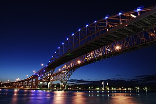
The Blue Water Bridge is a twin-span international bridge across the St. Clair River that links Port Huron, Michigan, United States, and Point Edward, Ontario, Canada. The Blue Water Bridge connects Highway 402 in Ontario with both Interstate 69 (I-69) and Interstate 94 (I-94) in Michigan.

<span class="mw-page-title-main">Richmond–San Rafael Bridge</span> Bridge crossing the San Francisco Bay

The Richmond–San Rafael Bridge is the northernmost of the east–west crossings of California's San Francisco Bay, carrying Interstate 580 from Richmond on the east to San Rafael on the west. It opened in 1956, replacing ferry service by the Richmond–San Rafael Ferry Company, and was officially renamed in 1981 to honor California State Senator John F. McCarthy, who championed the bridge's creation.

King's Highway 403, or simply Highway 403, is a 400-series highway in the Canadian province of Ontario that travels between Woodstock and Mississauga, branching off from and reuniting with Highway 401 at both ends and travelling south of it through Hamilton and Mississauga. It is concurrent with the Queen Elizabeth Way (QEW) for 22 km (14 mi) from Burlington to Oakville. The Highway 403 designation was first applied in 1963 to a short stub of freeway branching off the QEW, and the entire route was completed on August 15, 1997, when the section from Brantford to the then-still independent Town of Ancaster was opened to traffic. The section of Highway 403 between Woodstock and Burlington was formally dedicated as the Alexander Graham Bell Parkway on April 27, 2016, in honour of Alexander Graham Bell.

King's Highway 405, also known as Highway 405 and the General Brock Parkway, is a 400-Series Highway in the Canadian province of Ontario connecting the Queen Elizabeth Way (QEW) near St. Catharines with the Lewiston–Queenston Bridge in the village of Queenston. It then crosses the Niagara River, where it encounters the international border with the United States and continues into New York as Interstate 190 (I-190).

King's Highway 420, commonly referred to as Highway 420, is a 400-series highway in the Canadian province of Ontario that connects the Queen Elizabeth Way (QEW) with downtown Niagara Falls. It continues east as a limited-access expressway named Niagara Regional Road 420 to connect with the Rainbow Bridge international crossing between Canada and the United States over the Niagara River; this was part of Highway 420 until 1998. West of the QEW, the freeway ends at an at-grade intersection with Montrose Road. The highway has a speed limit of 80 kilometres per hour (50 mph), making it the only 400-series highway to have a speed limit less than 100 kilometres per hour (62 mph) for its entirety.

<span class="mw-page-title-main">Hamilton Harbour</span> Bay in western Lake Ontario, Ontario, Canada

Hamilton Harbour lies on the western tip of Lake Ontario, bounded on the northwest by the City of Burlington, on the south by the City of Hamilton, and on the east by Hamilton Beach and Burlington Beach. It is joined to Cootes Paradise by a narrow channel formerly excavated for the Desjardins Canal. Within Hamilton itself, it is referred to as "Hamilton Harbour", "The Harbour" and "The Bay". The bay is naturally separated from Lake Ontario by a sand bar. The opening in the north end was filled in and channel cut in the middle for ships to pass. The Port of Hamilton is on the Hamilton side of the harbour.

<span class="mw-page-title-main">Garden City Skyway</span> Highway bridge across the Welland Canal in Ontario, Canada

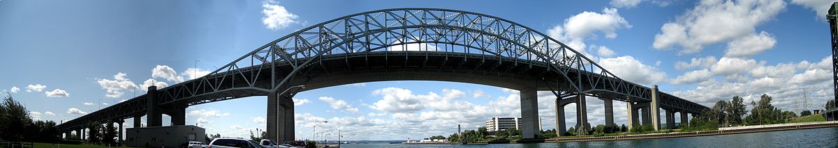
The Garden City Skyway is a major high-level bridge located in St. Catharines and Niagara-on-the-Lake, Ontario, Canada, that allows the Queen Elizabeth Way (QEW) to cross the Welland Canal without the interruption of a lift bridge. Six lanes of traffic are carried across the bridge, which is 2.2 kilometres (1.4 mi) in length and 40 metres (130 ft) at its tallest point.

<span class="mw-page-title-main">Eastern span replacement of the San Francisco–Oakland Bay Bridge</span> Seismic stabilization megaproject in California (2002–2013)

The eastern span replacement of the San Francisco–Oakland Bay Bridge was a construction project to replace a seismically unsound portion of the Bay Bridge with a new self-anchored suspension bridge (SAS) and a pair of viaducts. The bridge is in the U.S. state of California and crosses the San Francisco Bay between Yerba Buena Island and Oakland. The span replacement took place between 2002 and 2013, and is the most expensive public works project in California history, with a final price tag of $6.5 billion, a 2,500% increase from the original estimate of $250 million, which was an initial estimate for a seismic retrofit of the span, not the full span replacement ultimately completed. Originally scheduled to open in 2007, several problems delayed the opening until September 2, 2013. With a width of 258.33 ft (78.74 m), comprising 10 general-purpose lanes, it is the world's widest bridge according to Guinness World Records.

Mahatma Gandhi Setu is a bridge over the river Ganges in Bihar, India, connecting Patna in the south to Hajipur in the north. Its length is 5,750 metres (18,860 ft) and it is the third-longest river bridge in India. It was inaugurated in May 1982 in a ceremony in Hajipur by the then prime minister, Indira Gandhi. From 1982 to 2017, Mahatma Gandhi Setu remained as the longest bridge in India. Later, Gandhi Setu rehabilitation project was undertaken to install triangular steel trusses on Mahatma Gandhi Setu.

<span class="mw-page-title-main">Gantry (transport)</span> Structure on which road signs are mounted

A gantry is a traffic sign assembly in which signs are mounted or railway signals are supported on an overhead support. They also often contain the apparatus for traffic monitoring systems and cameras, or open road tolling systems.

King's Highway 20, commonly referred to as Highway 20, is a provincially maintained highway in the Canadian province of Ontario. Presently, it is a short 1.9 km (1.2 mi) stub between Highway 58 and Niagara Regional Road 70 in the City of Thorold, but until 1997 it connected Hamilton to Niagara Falls, serving several towns atop the Niagara Escarpment en route.

<span class="mw-page-title-main">Sgt. Aubrey Cosens VC Memorial Bridge</span> Bridge in Latchford, Ontario

The Sgt. Aubrey Cosens VC Memorial Bridge is a road bridge in Latchford, Ontario, which carries Ontario Highway 11, a branch of the Trans-Canada Highway system, across the Montreal River.

<span class="mw-page-title-main">Transportation in Hamilton, Ontario</span> Transportation infrastructure located in Hamilton, Ontario

Transport in Hamilton, Ontario consists of a variety of modes.

<span class="mw-page-title-main">Geography of Hamilton, Ontario</span>

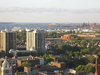
Hamilton is located on the western end of the Niagara Peninsula and wraps around the westernmost part of the Lake Ontario. Most of the city including the downtown section lies along the south shore. Situated in the geographic centre of the Golden Horseshoe, it lies roughly midway between Toronto and Buffalo. The two major physical features are Hamilton Harbour marking the northern limit of the city and the Niagara Escarpment running through the middle of the city across its entire breadth, bisecting the city into 'upper' and 'lower' parts.

<span class="mw-page-title-main">Beach Boulevard (Hamilton, Ontario)</span> Street in Canada

Beach Boulevard is a Lower city street in Hamilton, Ontario, Canada, east of the Hamilton Harbour on a thin piece of land that crosses over Lake Ontario and stretches from where Woodward Avenue becomes Eastport Drive in the south to near the Lift Bridge in the north at Eastport Drive (again). It runs parallel with the QEW and the Burlington Bay James N. Allan Skyway Bridge.

<span class="mw-page-title-main">San Mateo–Hayward Bridge</span> Road bridge across San Francisco Bay in California, United States

The San Mateo–Hayward Bridge is a bridge crossing the American state of California's San Francisco Bay, linking the San Francisco Peninsula with the East Bay. The bridge's western end is in Foster City, a suburb on the eastern edge of San Mateo. The eastern end of the bridge is in Hayward. It is the longest fixed-link bridge in California and the 25th longest in the world by length. The bridge is owned by the state of California, and is maintained by California Department of Transportation (Caltrans), the state highway agency. Further oversight is provided by the Bay Area Toll Authority (BATA).

<span class="mw-page-title-main">Burlington Canal Lift Bridge</span> Bridge in Ontario and Burlington, Ontario

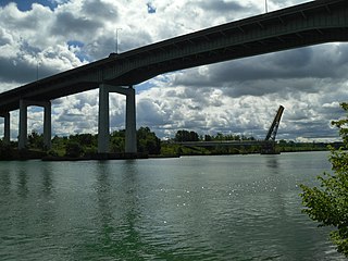
Burlington Canal Lift Bridge is a vertical lift bridge located to the north side of the Burlington Bay James N. Allan Skyway in Burlington, Ontario.

References

  1. Bouchier, Nancy B.; Cruikshank, Ken (2016). "Confining Nature". The People and the Bay: A Social and Environmental History of Hamilton Harbour. Vancouver, British Columbia: UBC Press. pp. 145, 158–159. ISBN   978-0-7748-3044-7 . Retrieved December 7, 2016.
  2. 1 2 Passfield, Robert W. (2007). "Philip Louis Pratley (1884–1958): bridge design engineer". Canadian Journal of Civil Engineering. 34 (5): 637–650. doi:10.1139/L06-130. alternate URL
  3. Van Dongen, Matthew; O'Reilly, Nicole (August 2, 2014). "Skyway bridge cleared after Thursday crash, lanes remain closed". Hamilton Spectator. Archived from the original on August 3, 2014. Retrieved August 1, 2014.
  4. 1 2 3 4 5 6 "Fast Facts from Hamilton's Past". Archived from the original on September 5, 2006. Retrieved January 8, 2007.
  5. "Burlington Skyway Bridge". Historic Bridges. 2016. Retrieved December 7, 2016.
  6. "Canada's First Skyway Opens 1958". Quebec Chronicle-Telegraph. November 27, 1957. Retrieved December 7, 2016.
  7. 1 2 3 "Oct. 30, 1958: Burlington Bay Skyway completed". Hamilton Spectator. September 23, 2016. Retrieved December 7, 2016.
  8. 1 2 Van Dongen, Matthew (February 21, 2014). "No takers for offer of Burlington lift bridge". Hamilton Spectator. Retrieved December 7, 2016.
  9. "Burlington Canal Lift Bridge - Ontario Region - PSPC". September 30, 2006.
  10. "Ontario Highway 401 Photographs - Page 8 - History of Ontario's Kings Highways". Thekingshighway.ca. Retrieved August 1, 2014.
  11. "Queen Elizabeth Way - Ontario | Flickr - Photo Sharing!". Flickr. June 12, 2004. Retrieved August 1, 2014.
  12. "Queen Elizabeth Way - Stoney Creek to Burlington - Images". Asphaltplanet.ca. Retrieved August 1, 2014.
  13. Whitnell, Tim (July 31, 2014). "Burlington Skyway Bridge damaged by dump truck". Hamilton Spectator. Retrieved December 7, 2016.
  14. O'Reilly, Nicole (August 4, 2014). "UPDATE: Skyway Bridge to reopen between 6 and 8 p.m." Hamilton Spectator. Retrieved December 7, 2016.
  15. Hayes, Molly (July 31, 2015). "Remember when a dump truck smashed into the Skyway Bridge?". Hamilton Spectator. Retrieved December 7, 2016.
  16. Peters, Ken (March 22, 2016). "Skyway crash driver guilty of dangerous driving". Hamilton Spectator. Retrieved December 7, 2016.
  17. Moro, Teviah (July 19, 2016). "'Shocking and frightening:' Burlington Skyway crash driver jailed a year". Hamilton Spectator. Retrieved December 7, 2016.
  18. "R. v. Rai, 2018 ONCA 623". CanLII. July 9, 2018.