
Maeshowe is a Neolithic chambered cairn and passage grave situated on Mainland Orkney, Scotland. It was probably built around 2800 BC. In the archaeology of Scotland, it gives its name to the Maeshowe type of chambered cairn, which is limited to Orkney.

Orkney, also known as the Orkney Islands, is an archipelago in the Northern Isles of Scotland, situated off the north coast of the island of Great Britain. Orkney is 10 miles (16 km) north of the coast of Caithness and has about 70 islands, of which 20 are inhabited. The largest island, Mainland, is often referred to as "the Mainland", and has an area of 523 square kilometres (202 sq mi), making it the sixth-largest Scottish island and the tenth-largest island in the British Isles. Orkney’s largest settlement, and also its administrative centre, is Kirkwall.

The Ring of Brodgar is a Neolithic henge and stone circle about 6 miles north-east of Stromness on Mainland, the largest island in Orkney, Scotland. It is part of the UNESCO World Heritage Site known as the Heart of Neolithic Orkney.
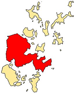
The Mainland, also known as Hrossey and Pomona, is the main island of Orkney, Scotland. Both of Orkney's burghs, Kirkwall and Stromness, lie on the island, which is also the heart of Orkney's ferry and air connections.

Unstan ware is the name used by archaeologists for a type of finely made and decorated Neolithic pottery from the 4th and 3rd millennia BC. Typical are elegant and distinctive shallow bowls with a band of grooved patterning below the rim, a type of decoration which was created using a technique known as "stab-and-drag". A second version consists of undecorated, round-bottomed bowls. Some of the bowls had bits of volcanic rock included in the clay to make them stronger. Bone tools were used to burnish the surfaces to make them shiny and impermeable.

The Standing Stones of Stenness is a Neolithic monument five miles northeast of Stromness on the mainland of Orkney, Scotland. This may be the oldest henge site in the British Isles. Various traditions associated with the stones survived into the modern era and they form part of the Heart of Neolithic Orkney World Heritage Site. They are looked after by Historic Environment Scotland as a scheduled monument.

The Neolithic Barnhouse Settlement is sited by the shore of Loch of Harray, Orkney Mainland, Scotland, not far from the Standing Stones of Stenness, about 5 miles north-east of Stromness.

Gairsay is a small island in Orkney, Scotland, located in the parish of Rendall, 1.5 miles (2.4 km) off the coast, astride one of the approaches to the bays of Firth and Kirkwall. It is about 2 miles (3.2 km) long and 1 mile (1.6 km) wide and includes one conical hill and a small harbour called Millburn Bay, which is sheltered by the peninsula known as the Hen of Gairsay.

Heart of Neolithic Orkney refers to a group of Neolithic monuments found on the Mainland of the Orkney Islands, Scotland. The name was adopted by UNESCO when it proclaimed these sites as a World Heritage Site in 1999.
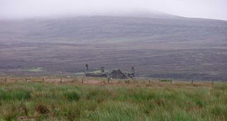
Stines Moss is an elevated bog in the southwest upland area of the Orkney Mainland, Scotland.

Mor Stein is a neolithic standing stone in the southeastern part of the island of Shapinsay, Orkney Islands, Scotland. Shapinsay is one of the two large inner islands of the Orkney group, and it is situated approximately two miles north of the Orkney Mainland. Linton Bay is situated slightly to the northeast of Mor Stein.

The Mill of Ayreland is an historic watermill driven by water force of the Burn of Ayreland, a northwesterly flowing coastal stream within Mainland Orkney, Scotland, that empties into the Clestrain Sound approximately five kilometres southerly of Stenness.

The Loch of Stenness is a large brackish loch on Mainland, Orkney, Scotland and is named for the parish of Stenness. It is 2 miles northeast of the town of Stromness, lies immediately to the south of the Loch of Harray and is close to the World Heritage neolithic sites of the Stones of Stenness and Ring of Brodgar. In Old Norse its name was Steinnesvatn.

The Loch of Harray is the largest loch of Mainland Orkney, Scotland and is named for the parish of Harray. It lies immediately north of the Loch of Stenness and is close to the World Heritage neolithic sites of the Stones of Stenness and Ring of Brodgar. In Old Norse its name was Heraðvatn.
Rinyo was a Neolithic settlement on Rousay in Orkney, Scotland. The site was discovered in the winter of 1837–38 on the lands of Bigland Farm in the north east of the island at grid reference HY439322.

Prehistoric Orkney refers only to the prehistory of the Orkney archipelago of Scotland that begins with human occupation. Although some records referring to Orkney survive that were written during the Roman invasions of Scotland, “prehistory” in northern Scotland is defined as lasting until the start of Scotland’s Early Historic Period (around AD 600.

The Ness of Brodgar is an archaeological site covering 2.5 hectares between the Ring of Brodgar and the Stones of Stenness in the Heart of Neolithic Orkney World Heritage Site in Orkney, Scotland. Excavations at the site began in 2003. The site has provided evidence of decorated stone slabs, a stone wall 6 metres (20 ft) thick with foundations, and a large building described as a Neolithic temple. The earliest structures were built between 3,300 and 3,200 BC, and the site had been closed down and partly dismantled by 2,200 BC. It was the main subject of a 2016 BBC Scotland documentary, Britain’s Ancient Capital: Secrets of Orkney, presented by Neil Oliver, Chris Packham, Shini Somara, Andy Torbet and Doug Allan.

Hoy Sound is a body of salt water subject to tidal currents situated south of the town of Stromness in the Orkney archipelago of Scotland.

The architecture of Scotland in the prehistoric era includes all human building within the modern borders of Scotland, before the arrival of the Romans in Britain in the first century BCE. Stone Age settlers began to build in wood in what is now Scotland from at least 8,000 years ago. The first permanent houses of stone were constructed around 6,000 years ago, as at Knap of Howar, Orkney and settlements like Skara Brae. There are also large numbers of chambered tombs and cairns from this era, particularly in the west and north. In the south and east there are earthen barrows, often linked to timber monuments of which only remnants remain. Related structures include bank barrows, cursus monuments, mortuary enclosures and timber halls. From the Bronze Age there are fewer new buildings, but there is evidence of crannogs, roundhouses built on an artificial islands and of Clava cairns and the first hillforts. From the Iron Age there is evidence of substantial stone Atlantic roundhouses, which include broch towers, smaller duns. There is also evidence of about 1,000 hillforts in Scotland, most located below the Clyde-Forth line.

Hoy and West Mainland is a national scenic area (NSA) covering parts of the islands of Hoy and Mainland in the Orkney Islands of Scotland, as well as parts of the surrounding sea. It is one of 40 such areas in Scotland, which are defined so as to identify areas of exceptional scenery and to ensure its protection by restricting certain forms of development. The Hoy and West Mainland NSA covers 24,407 ha in total, consisting of 16,479 ha of land with a further 7928 ha being marine.
