Labrador is a geographic and cultural region within the Canadian province of Newfoundland and Labrador. It is the primarily continental portion of the province and constitutes 71% of the province's area but is home to only 6% of its population. It is separated from the island of Newfoundland by the Strait of Belle Isle. It is the largest and northernmost geographical region in the four Atlantic provinces.

Ferryland is a provincial electoral district for the House of Assembly of Newfoundland and Labrador, Canada. As of 2011, there are 8,571 eligible voters living within the district.

Torngat Mountains National Park is a Canadian national park located on the Quebec-Labrador Peninsula in the province of Newfoundland and Labrador. The park encompasses 9,700 km2 of mountainous terrain between Northern Quebec and the Labrador Sea. It is the largest national park in Atlantic Canada and the southernmost national park in the Arctic Cordillera. It partially contains the Torngat Mountains, the highest mountains in mainland Canada east of the Rocky Mountains.
Raleigh is a town located northwest of St. Anthony. It had a population of 295 in 1956, declining to 150 by the 2021 census.

The East Coast Trail (ECT) is a long-distance coastal footpath located in the Canadian province of Newfoundland and Labrador. It is a developed trail over 336 kilometres (209 mi) long, the creation of which began in 1994. It is made up of 25 linked wilderness paths and passes through more than 30 communities. It was named one of the best adventure destinations by National Geographic in 2012 and is extended and improved yearly.
Articles related to the Canadian province of Newfoundland and Labrador include:

Cape St. Mary's Ecological Reserve is an ecological reserve located near Cape St. Mary's on the Cape Shore, on the southwestern Avalon Peninsula of Newfoundland.
Lord's Cove is a town in the Canadian province of Newfoundland and Labrador. The town had a population of 155 in the Canada 2021 Census. Lord's Cove has an inshore fishing history. The town is approximately 65 km southeast of Marystown.

Witless Bay is a town on the Avalon Peninsula in the Canadian province of Newfoundland and Labrador. Located on the Irish Loop, 35 km south of the provincial capital, St. John's, Witless Bay is a small, scenic, traditional Newfoundland outport community. The town had a population of 1640 in the Canada 2021 Census. It is connected to the Witless Bay Ecological Reserve.
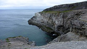
Pistolet Bay is a natural bay located on the northern tip of the Great Northern Peninsula of the island of Newfoundland, in the Canadian province of Newfoundland and Labrador.

The headland of Cape St. Mary's is located at the southern tip of the south-western arm of the Avalon Peninsula of the island of Newfoundland in the Canadian province of Newfoundland and Labrador.

Fractofusus misrai is an Ediacaran fossil discovered in 1967 by S.B. Misra at Mistaken Point, Newfoundland and Labrador, Canada, which has since become the Mistaken Point Ecological Reserve. It was named after Professor Misra in 2007. It represents a frondose rangeomorph, and its overall body plan shows glide reflection symmetry, which is typical of the clade. It is one of two described species in the genus Fractofusus, the other being Fractofusus andersoni.

Mistaken Point Ecological Reserve is a wilderness area and a UNESCO World Heritage Site located at the southeastern tip of Newfoundland's Avalon Peninsula in the Canadian province of Newfoundland and Labrador. The reserve is home to the namesake Mistaken Point Formation, which contains one of the most diverse and well-preserved collections of Precambrian fossils in the world. Ediacaran fossils discovered at the site constitute the oldest known remnants of multicellular life on Earth.

Cape Bonavista Light is a lighthouse located on Cape Bonavista, Newfoundland. The lighthouse, which operated from 1843 until 1962, is now a provincial museum, containing an exhibition about life in a lighthouse during the 1870s.

The following outline is provided as an overview of and topical guide to Newfoundland and Labrador.
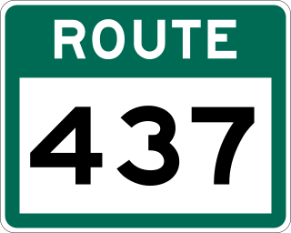
Route 437, also known as Cape Onion Road, is a 22.1-kilometre-long (13.7 mi) north-south highway on the northern edge of the Great Northern Peninsula of Newfoundland in the Canadian province of Newfoundland and Labrador. It connects the communities of Cape Onion-Ship Cove and Raleigh, along with Pistolet Bay Provincial Park, with Route 436 and St. Anthony.

South Avalon-Burin oceanic barrens is a taiga ecoregion located within the Canadian province of Newfoundland and Labrador and the French overseas collectivity of Saint Pierre and Miquelon. It is defined by the World Wildlife Fund (WWF) categorization system as inhabiting the southern headlands of the Avalon and Burin Peninsulas along the southeastern coast of Newfoundland.
Burnt Cove, St. Michael's, Bauline South is a local service district and designated place in the Canadian province of Newfoundland and Labrador.
Burnt Point-Gull Island-Northern Bay is a local service district and designated place in the Canadian province of Newfoundland and Labrador.