
Burton upon Trent, also known as Burton-on-Trent or simply Burton, is a market town in the borough of East Staffordshire in the county of Staffordshire, England, close to the border with Derbyshire. In 2011, it had a population of 72,299. The demonym for residents of the town is Burtonian. Burton is 11 miles (18 km) southwest of Derby, 27 miles (43 km) northwest of Leicester, 28 miles (45 km) west-southwest of Nottingham and 20 miles (32 km) south of the southern entrance to the Peak District National Park.

East Staffordshire is a local government district with borough status in Staffordshire in England. It has two main towns: Burton upon Trent and Uttoxeter.
Penkridge is a village and civil parish in South Staffordshire District in Staffordshire, England. It is to the south of Stafford, north of Wolverhampton, west of Cannock and east of Telford. The nearby town of Brewood is also not far away.

Stone is a constituency represented in the House of Commons of the UK Parliament since its 1997 recreation by Bill Cash, a Conservative.
Stretton is a large village and civil parish in Staffordshire, England. It is situated on the northern outskirts of Burton upon Trent and is effectively a suburb of that town. The name is Old English and means Street Town and comes it being on the Roman road called Ryknild Street. The population of the parish at the 2001 census was 8,355, increasing to 8,611 at the 2011 Census.
Anglesey is a civil parish in the East Staffordshire district of Staffordshire, England. It covers an area in the south of Burton upon Trent, south of the town centre, around Anglesey Road. According to the 2001 census it had a population of 5,835, increasing to 6,809 at the 2011 census.
Anslow is a village and civil parish in the East Staffordshire district of Staffordshire, England, about three miles [4.8 km] north-west of Burton upon Trent. According to the 2001 census, the parish, which includes Anslow Gate had a population of 669, increased to 805 at the 2011 census.

Brizlincote is a civil parish in Burton upon Trent in East Staffordshire, England. The population of the civil parish as taken at the 2011 census was 5,385. It is in the south-east of the town.

Stanton is a small village situated at the eastern end of the Weaver Hills, Staffordshire, England.

Streethay is an English village in the civil parish of Fradley and Streethay adjoining the city of Lichfield, Staffordshire on the east side of the West Coast Main Line railway. The parish council is a joint one with Fradley.
Winshill is an area to the east of the town of Burton upon Trent, in the borough of East Staffordshire, England.
Outwoods is a civil parish in the English county of Staffordshire. Once a village it is now a suburb on the flanks of the town of Burton upon Trent separated from the town by the A38 road.

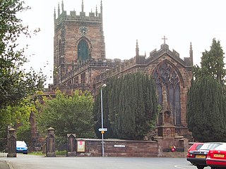
St Modwen's is a Church of England parish church situated in Burton upon Trent in Staffordshire, England. It is part of the Diocese of Lichfield. The church is dedicated to St Modwen, or Modwenna, a nun who founded an abbey at Burton in the 7th century.

Shobnall is a settlement and civil parish located in Staffordshire, England. It covers an area located in the west of Burton upon Trent. The population of Shobnall taken at the 2011 census was 5,071.
Horninglow and Eton is a civil parish in the district of East Staffordshire, Staffordshire, England. It contains six listed buildings that are recorded in the National Heritage List for England. Of these, one is listed at Grade I, the highest of the three grades, and the others are at Grade II, the lowest grade. The parish is to the northwest of Burton upon Trent and is mainly residential. The most important listed building is St Chad's Church, and the war memorial in its churchyard is also listed. Remainders of the parish's industrial past are a former hydraulic power house and a former railway warehouse. The other listed buildings are a farmhouse and a milepost.
Anglesey is a civil parish in the district of East Staffordshire, Staffordshire, England. The parish contains two listed buildings that are recorded in the National Heritage List for England. Both the listed buildings are designated at Grade II, the lowest of the three grades, which is applied to "buildings of national importance and special interest". The parish is in the southern part of the town of Burton upon Trent, and both listed buildings are former breweries.
Winshill is a civil parish in the district of East Staffordshire, Staffordshire, England. The parish contains four listed buildings that are recorded in the National Heritage List for England. All the listed buildings are designated at Grade II, the lowest of the three grades, which is applied to "buildings of national importance and special interest". The parish is in the eastern part of the town of Burton upon Trent. The listed buildings consist of a former flour mill and an associated building, a milepost, and a church.
Outwoods is a civil parish in the district of East Staffordshire, Staffordshire, England. The parish contains two listed buildings that are recorded in the National Heritage List for England. Both the listed buildings are designated at Grade II, the lowest of the three grades, which is applied to "buildings of national importance and special interest". The parish is to the northwest of Burton upon Trent, and the listed buildings are mileposts of different styles.

Elections to Staffordshire County Council took place on 6 May 2021 on the same day as district council elections in Cannock Chase and Tamworth and other local elections in England. All of the council's divisions were up for election, meaning a total of 62 councillors were elected.
